Download
1 / 1
10 likes | 147 Views
High-Resolution Maps of Outlet Glacier Surface Elevation Change from Combined Laser Altimeter and Digital Elevation Model Data (ID # 962139). F A C U L T Y O F S C I E N C E U N I V E R S I T Y O F C O P E N H A G E N.

E N D
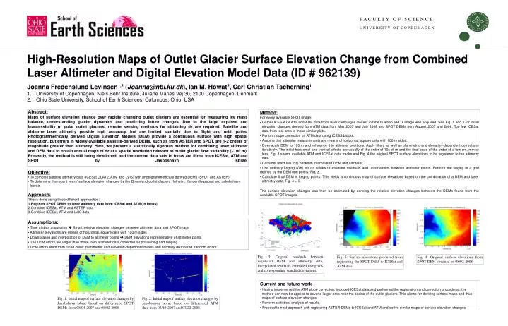
High-Resolution Maps of Outlet Glacier Surface Elevation Change from Combined Laser Altimeter and Digital Elevation Model Data (ID # 962139) F A C U L T Y O F S C I E N C E U N I V E R S I T Y O F C O P E N H A G E N • Joanna Fredenslund Levinsen1,2 (Joanna@nbi.ku.dk), Ian M. Howat2, Carl Christian Tscherning1 • University of Copenhagen, Niels Bohr Institute, Juliane Maries Vej 30, 2100 Copenhagen, Denmark • Ohio State University, School of Earth Sciences, Columbus, Ohio, USA Abstract: Maps of surface elevation change over rapidly changing outlet glaciers are essential for measuring ice mass balance, understanding glacier dynamics and predicting future changes. Due to the large expanse and inaccessibility of polar outlet glaciers, remote sensing methods for obtaining dz are required. Satellite and airborne laser altimetry provide high accuracy, but are limited spatially due to flight and orbit paths. Photogrammetrically derived Digital Elevation Models (DEM) provide a continuous surface with high spatial resolution, but errors in widely-available satellite-derived DEMs, such as from ASTER and SPOT, are 1-2 orders of magnitude greater than altimetry. Here, we present a statistically rigorous method for combining laser altimeter and DEM data to obtain annual maps of dz at a spatial resolution relevant to outlet glacier flow variability (~100 m). Presently, the method is still being developed, and the current data sets in focus are those from ICESat, ATM and SPOT by Jakobshavn Isbrae. • Method: • For every available SPOT image: • Gather ICESat GLA12 and ATM data from laser campaigns closest in time to when SPOT image was acquired. See Fig. 1 and 2 for initial elevation changes derived from ATM data from May 2007 and July 2008 and SPOT DEMs from August 2007 and 2008. Too few ICESat data from test area to make similar plots. • Perform slope correction on ATM data using ICESS blocks. • Assume that altimeter measurements are means of horizontal, square cells with 100 m sides. • Downscale DEM to 100 m and reference it to altimeter positions: Apply filters as well as planimetric and elevation-dependent corrections iteratively. The initial horizontal and vertical offsets are usually of the order of 10s of m and the final ones of the order of a few cm, mm or less. Fig. 3 shows available ATM and ICESat data tracks and Fig. 4 the original SPOT surface elevations to be registered to the altimetry data. • Consider residuals (dz) between interpolated DEM and altimeter. • Use ordinary kriging (OK) on dz values to estimate residuals and uncertainties between altimeter points. Perform the kriging in a grid defined by the DEM end points. Fig. 3. • Calculate final DEM in kriging points. This yields a continuous map of surface elevations based on the combination of a DEM and laser altimetry data, Fig. 4 + 5. • The surface elevation changes can then be estimated by deriving the relative elevation changes between the DEMs found from the available SPOT images. • Objective: • To combine satellite altimetry data (ICESat GLA12, ATM and LVIS) with photogrammetrically derived DEMs (SPOT and ASTER). • To determine the recent years’ surface elevation changes by the Greenland outlet glaciers Helheim, Kangerdlugssuaq and Jakobshavn Isbrae. • Approach: • This is done using three different approaches: • Register SPOT DEMs to laser altimetry data from ICESat and ATM (in focus) • Combine ICESat, ATM and ASTER data • Combine ICESat, ATM and LVIS data • Assumptions: • Time of data acquisition Small, relative elevation changes between altimeter data and SPOT image • Altimeter elevations are means of horizontal, square cells with 100 m sides • Downscaling and interpolation of DEM to altimeter points DEM elevations representative of altimeter points • The DEM errors are larger than those from altimeter data corrected for positioning and ranging • DEM errors stem from cloud cover, planimetric and elevation-dependent biases and normally distributed, random errors Fig. 3: Original residuals between registered DEM and altimetry data, interpolated residuals estimated using OK and corresponding standard deviations. Fig. 5: Surface elevations produced from registering the SPOT DEM to ICESat and ATM data. Fig. 4: Original surface elevations from SPOT DEM obtained on 08/02-2008. • Current and future work • Having implemented the ATM slope correction, included ICESat data and performed the registration and correction procedures, the method can now be applied to cover a larger area near the basins of the outlet glaciers. This allows for deriving surface maps and thus maps of surface elevation changes. • Perform statistical analysis of results. • Proceed to next approach with registering ASTER DEMs to ICESat and ATM and derive similar maps of surface elevation changes. Fig. 1: Initial map of surface elevation changes by Jakobshavn Isbrae based on differenced SPOT DEMs from 08/04-2007 and 08/02-2008. Fig. 2: Initial map of surface elevation changes by Jakobshavn Isbrae based on differenced ATM data from 05/10-2007 and 07/22-2008.