Download
1 / 29
290 likes | 516 Views
Module 6: Geoprocessing Scripts. Processing loops and decisions. Most COM compliant scripting languages. AML (Arc Macro Language) VB script Jscript PERL Python (comes with ArcGIS). Python. Platform independent (linux, unix, windows) Object-oriented, developer language

E N D
Most COM compliant scripting languages • AML (Arc Macro Language) • VB script • Jscript • PERL • Python (comes with ArcGIS)
Python • Platform independent (linux, unix, windows) • Object-oriented, developer language • Good website (www.python.org) • Comes with ArcGIS, free from web
Installing Python • ArcGIS Desktop CD • Explore rather than open to avoid autoinstallation of ArcGIS
In Python folder.. • Run both exe files
# polygon_to_poly_line.py# Created on: Fri Dec 31 2004 12:34:54 PM# (generated by ArcGIS/ModelBuilder)# Import system modulesimport sys, string, os, win32com.client# Create the Geoprocessor objectgp =win32com.client.Dispatch("esriGeoprocessing.GpDispatch.1")# Set the ArcGIS product code (Arcview, ArcEditor, or ArcInfo)gp.SetProduct("ArcInfo") • Python system • String module • Operating System • COM Dispatch
# Load required toolboxes...gp.AddToolbox("C:/workshop_geoprocessing/ExampleToolbox.tbx")# Local variables...poly_lines_shp = "C:/temp/poly_lines.shp"selected_polygons_shp = "C:/temp/selected_polygons.shp"# Process: Polygon To Line...gp.toolbox = "C:/workshop_geoprocessing/ExampleToolbox.tbx"gp.PolygonToLine(selected_polygons_shp, poly_lines_shp)
# Script arguments or variables...Input_Features = sys.argv[1]Output_Feature_Class = sys.argv[2]# Process: Polygon To Line...gp.toolbox = "C:/temp/My Toolbox.tbx"gp.PolygonToLine(Input_Features, Output_Feature_Class)
# use + to concatenate strings:# single or double-quotes enclose string charsname = ‘moose_locations’type = “.shp”shapefile = name + typeprint shapefilemoose_locations.shp
# decisions or branching:# indentation used to indicate structureiftype == 'point': print 'Theme is point type' print 'Must be polygon type to use erase tool'elif type == 'polyline' : print 'Theme is polyline type' print 'Convert to polygon type, then rerun script'elif type == 'polygon': print 'Theme is polygon type' print 'Correct feature type for using erase tool'else: print "Theme type is not point, line, or polygon"print “End of Script” #out of if block
List first 2 pond polygon feature classes # Import system modules import sys, string, os, win32com.client # Create the Geoprocessor object gp = win32com.client.Dispatch("esriGeoprocessing.GpDispatch.1") #set workspace gp.workspace = "C:/ponds "; print "workspace set to: ", str(gp.workspace) #get list of feature classes fcs = gp.ListFeatureClasses("pond*","polygon") fcs.reset() #get first two objects in list and assign to variables theme1, theme2: theme1 = fcs.next() theme2 = fcs.next() print "First two polygon themes in workspace: ", str(theme1), str(theme2)
List all pond polygon feature classes # Import system modules import sys, string, os, win32com.client # Create the Geoprocessor object gp = win32com.client.Dispatch("esriGeoprocessing.GpDispatch.1") #set workspace gp.workspace = "C:/ponds“; print "workspace set to: ", str(gp.workspace) #get list of feature classes fcs = gp.ListFeatureClasses("pond*","polygon") fcs.reset() # Get the first theme and start the loop Current_Theme = fcs.next() while Current_Theme: # While the Current_Theme is not empty Print “Current theme in list is:”, str(Current_Theme) Current_Theme = fcs.next() Print “End of Script”
Convert all pond polygon to line themes # Import system modules import sys, string, os, win32com.client # Create the Geoprocessor object gp = win32com.client.Dispatch("esriGeoprocessing.GpDispatch.1") #set workspace gp.workspace = "C:/ponds"; print "workspace set to: ", str(gp.workspace) #get list of feature classes fcs = gp.ListFeatureClasses("pond*","polygon") fcs.reset() print "All pond polygon themes will be converted to pond shoreline themes..." # Get the first theme and start the loop Current_Theme = fcs.next() while Current_Theme: # While the Current_Theme is not empty print "Converting Theme:", str(Current_Theme) gp.PolygonToLine(Current_Theme, "c:/shorelines/" + Current_Theme) Current_Theme = fcs.next() print "End of Script"
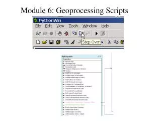
1) Check for syntax errors 2) Step Through Script Using Debugger
Sources of Confusion • Python commands and variables are case sensitive ( print theme <> Print theme <> print Theme ) • Geoprocessor properties not case sensitive ( gp.workspace = gp.WorkSpace ) \ is a reserved character meaning line continuation (use / or \\ for paths instead of \) • Indentation is a source of loop structure
Sources of Confusion • Model does not use UML like ArcObjects • Arrows indicate instantiation • Only non character properties are indicated in diagram