Download
1 / 26
260 likes | 266 Views
This presentation provides an overview of migrating data to the Local Government Information Model, including configuration patterns, demonstrations, and steps to load data into the model.

E N D
July 24, 2012 Migrating Data to theLocal Government Information Model Scott Oppmann Steve Grise Steve MacCabe
Agenda • Introduction • Configuration Patterns • Demonstrations • Configuring the Information Model • Load Data in to the Information Model • What’s Next • Your Feedback
ArcGIS for Local Government A solution for Esri’s local government customers • A series of useful maps and apps focused on local government work • Organized into modules • Extensible, configurable • A foundation for Partner solutions • An online community • Best Practices / Implementation Support • A network of Esri Services and Partner offerings • Help users implement, sustain and enhance Mobile Apps Web Apps Basemaps Models/Charts Editing Workflows Local Government Information Model …..Available on-premise or in the cloud
Our Mission Help increase the value of GIS in local government organizations Make it easier to deploy ArcGIS Deliver applications quickly throughout your organization Stay current with future releases / avoid legacy technology Create a platform of geospatial data that can be leveraged by many Address common constraints in local government Size and skills of staff Budget and time available to implement Empower the community to contribute Users Partners
ArcGIS for Local Government Changing the way GIS is deployed
Local Government Community An online community where Local Government users and partners can collaborate
Configuration Patterns • Influential factors • COTS and configurable solutions strategy • Deployment time • Technical expertise • Three configuration patterns • Complete system adoption • Publish and adopt • Sample code and customize • Where do you start? • With your business requirements (NOT the GDB!) • Align them with maps and apps • Review system configuration patterns
Complete System Adoption • Configure GDB schema • Add fields, features • Configure domains • Set spatial reference • Load source data Step 1: Organize your data • Configure maps • Adjust scale dependencies and def queries • Validate label expressions • Publish basemaps and map services Step 2: Author the maps • Configure the desktop, mobile and web apps • Add basemaps and map services • Adjust extents • Configure popups • Deploy Add-ins and models Step 3: Deploy the apps • Supported by Esri Support Services
Publish and Adopt • Configure GDB schema • Add fields, features • Configure domains • Set spatial reference • Create ETL Scripts • Set source / target • Schedule scripts • Migrate production data Step 1: Create publication database Step 2: Load production data • Configure maps • Adjust scale dependencies and def queries • Validate label expressions • Publish basemaps and map services Step 3: Author the maps • Configure the mobile and web apps • Add basemaps and map services • Adjust extents • Configure popups Step 4: Deploy the apps • Supported by Esri Support Services
Sample Code and Customize • Configure your GDB schema • Add fields, features Step 1: Use your GDB Schema • Configure maps • Repair map layers (source and symbology) • Adjust scale dependencies and def queries • Validate label expressions • Publish basemaps and map services • Or, just try to use your maps… Step 2: Repair the maps • Publish your own mobile and web apps • Customize/re-compile the apps • Add basemaps and map services • Adjust extents • Configure popups Step 3: Customize the apps • NOT supported by Esri Support Services
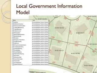
Configuring the Information Model • Supports maps and apps • Known local government requirements • Easy to adopt and extend • Fully documented • Features, layers and packages • Central repository, organized around thematic content and logical permission model • Organized access/maintenance patterns • GDB replication, layers and services • Tip • Xray for ArcCatalog and ArcMap • Safe FME and Esri Data Interop Extension • Start with the layer and field aliases and work from there….
Demo Steve Grise Vertex3, Inc.
X-Ray for ArcGIS X-Ray is a part of ArcGIS that helps you build better Maps and Geodatabases Developed by Vertex3 in collaboration with Esri and expert ArcGIS users Supported by Esri Freely distributed on ArcGIS.com
What can I use it for? • View the details of your maps and Geodatabases • Manage/Edit your Design • With practical, simple, round-trip tools • Manage Content later in the project lifecycle • Tailor ArcGIS Templates for your organization • Build new templates for your customers and/or country
X-Ray for ArcGIS - Demo X-Ray provides ArcMap & ArcCatalog Add-Ins for designing and managing GIS content 10 Major Enhancements in 2012
Summary • Showed examples using X-Ray to manage your design/implementation • Specialized tools for implementation • Works with all ArcGIS tools • Round-trip design • Multi-tool • Full Geodatabase model • Design and Manage
Demo Steve MacCabe Safe Software
FME Technology • Esri Local Government Information Model • Pain Point: Customers wanting to populated the Loc Gov Information Model • Solution: Esri Data Interop or FME Desktop • Esri and Safe collaboration • Spatial ETL tools and FME Workspaces • Walk through Polling Places and Election Results workflows • Creating more Spatial ETL and FME Workspaces
Summary • Local Government Information Model Resources • Esri Data Interop • FME Desktop • More Coming: • Check ArcGIS Online for “FME” to see What’s Available
What’s Next Solution Offering Quarterly Releases Improved help documentation, videos, etc. Complementary Partner offerings Safe FME Workspaces, FMEpedia articles, videos, etc. Model Online Implementation Roles, Groups, Information Products, Configurable Apps, etc.
What’s Next Additional Maps and Apps Public Safety Fire Incident Command Cell Phone Analysis/Investigation Planning and Economic Development Site Selection/Economic Gardening Well and Septic Permitting Land Records Field Assessment Operations Dashboard • Public Works and Water Utilities • Capital Project Coordination • Stormwater Assessment • One Call • Capital Planning (Roads) • Sign Inspection • Management • Executive Dashboard
Summary • Identify the business needs of your organization • Evaluate the state of your data holdings • Select a configuration pattern that makes sense for your organization • Don’t hesitate to ask for help from • Esri • Partners
ArcGIS for Local GovernmentUC Sessions Click Here
Questions Please fill out your surveys www.esri.com/ucsessionsurveys Offering ID:160 • Steve Grisé • steve@vertex3.com • Steve MacCabe • steve.maccabe@safe.com @ArcGISLocalGov arcgisteamlocalgov@esri.com