Download
1 / 32
340 likes | 475 Views
September 14, 2012. AeroMetric , Inc. The Airports GIS Design / As-Built Project. Presenter Todd G. Johnson, Airport Solutions Specialist. AeroMetric , Inc. The Airports GIS Design / As-Built Project. Presenter Todd G. Johnson, Airport Solutions Specialist. Faa Airports Gis

E N D
September 14, 2012 AeroMetric, Inc.The Airports GIS Design /As-Built Project Presenter Todd G. Johnson, Airport Solutions Specialist
AeroMetric, Inc.The Airports GIS Design /As-Built Project Presenter Todd G. Johnson, Airport Solutions Specialist
Faa Airports Gis Design/As-built Projects Presentation Audience • All personnel involved in airport projects Presentation Topics • What is FAA Airports GIS? • Why FAA Airports GIS? What are the benefits? • What is a Design/As-Built airport project? • What constitutes a Design/As-Built project? • Breaking the “Extra Cost” Paradigm • Why should YOU care? The airports gis Design / As-built project Presented by: Todd G. Johnson Airport Solutions Specialist
What is FAA Airports GIS? The airports gis Design / As-built project Presented by: Todd G. Johnson Airport Solutions Specialist
What is FAA Airports GIS? • An online airport project management/coordination tool • Used to manage ALL airport construction projects, • Used to manage data on safety critical airport features, • Used to create new, or coordinate updates to, airport master plans, • Used to tracks submittals/reviews of airport aerial imagery, • Supports the FAA Next Generation (NextGen) initiative
Why Airports GIS? • What are the benefits? The airports gis Design / As-built project Presented by: Todd G. Johnson Airport Solutions Specialist
What is a Design/As-Built airport project? The airports gis Design / As-built project Presented by: Todd G. Johnson Airport Solutions Specialist
The airports gis Design / As-built project What is a Design/As-Built airport project? An airport construction project that consists of two phases: an “Engineering Design” phase, and an “As-Built Validation” phase Presented by: Todd G. Johnson Airport Solutions Specialist A paradigm exists that this is a new type of FAA airport project, type and that there will be extra costs involved. NOT TRUE!
What constitutes a Design/As-Built project? The airports gis Design / As-built project Presented by: Todd G. Johnson Airport Solutions Specialist
What constitutes a Design/As-Built project? New Airport or Runway Construction
What constitutes a Design/As-Built project? AAA-VG/NVG RSA Issues Moving Runway Ends Runway Extensions, Reductions, or Relocations
What constitutes a Design/As-Built project? NAVAID Construction or Relocation
What constitutes a Design/As-Built project? It basically boils down to this… • Any new airport projects that require… • An Engineering Design to be submitted to the FAA, • Changes to airport safety critical features, • FAA AeroNav Services (Instrument Procedure Design – IPD), • An FAA aeronautical obstruction or airspace study (OE/AAA), • Runway additions, relocations or extensions, • Requires NAVAIDs to be installed or relocated This is not a complete list…when in doubt, ask your Regional or ADO Managers, or submit a ticket to the FAA Airports GIS Help Desk
Breaking the Extra Cost Paradigm The airports gis Design / As-built project Presented by: Todd G. Johnson Airport Solutions Specialist
Breaking the Extra Cost Paradigm 1st Project 2nd Project Old Design/As-Built process (Two Ways) • Two Separate Airports GIS projects, or • Single Project “Design Data” Workaround 1st Project – Design Phase Project • Submit Statement of Work (SOW) • Submit required Plans • No imagery submitted with design data • Submit Engineering Design • NGS Action - Cursory review / “conditional” approval • NGS Action - Submits data to AeroNav Services • Project is closed 2nd Project – As-BuiltPhase Project • Submit duplicate of SOW • Submit duplicate of Plans • Submit Aerial Imagery • NGA Action – Verify / Approve imagery • Perform As-Built / Submit deliverable to Airports GIS • NGS Action - Full As-Built data verification • NGS Action - Submits to AeroNav Services • Project closed / airport data updated by FAA / NFDC
Breaking the Extra Cost Paradigm Single Project Workaround Old Design/As-Built process (Two Ways) • Two Separate Airports GIS projects, or • Single Project “Design Data” Workaround Single Project “Design Data” Workaround • Submits Statement of Work (SOW) • Submits required Plans • Submits Engineering Design to “Test a Survey File” area, NOT TO THE PROJECT! • Submit Help Desk Ticket - survey ready for IPD • Help Desk reviews survey data / SOW • Design data sent to AeroNav Services • AeroNav Services starts IPD • Consultant submits aerial imagery to NGS • Complete / submit As-Built survey data to project • NGS validates / approves As-Built data • As-Built data sent to AeroNav Services • Project closed / airport data updated by National Flight Data Center (NFDC)
Breaking the Extra Cost Paradigm The Airports GIS Design/As-Built project IS NOT A NEW TYPE OF AIRPORT PROJECT!
Breaking the Extra Cost Paradigm The Airports GIS Design/As-Built Project Merges all workarounds into ONE project Easier to manage
The Design/As-Built Project Timeline • 2-years+ prior to project completion - Initiate FAA Airports GIS project • 18-months prior to project completion - Submit final Engineering Design • Complete FAA Airspace Analysis (OE/AAA) – Log complete in project • Complete Environmental Impact Study (EIS) - Log complete in project • Begin Construction - Log complete in project • End Construction - Log complete in project • Submit Aerial Imagery - Log mailing date/tracking number in project • Collect / validate As-Built data – One-to-one data comparison to design • Submit As-Built data to Airports GIS – Correct/update as required • Project complete after all data/imagery has been verified by FAA
Safety and Liability Scenario The airports gis Design / As-built project Presented by: Todd G. Johnson Airport Solutions Specialist
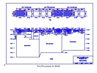
Safety and Liability Scenario Ultimately, the FAA wants to keep things like this from happening! Runway Extension Scenario Standard runway with no obstacles within the 40:1 approach/departure surface. No modifications have been made. GREAT LANDING CHARLIE! 40:1 Approach/Departure Surface RUNWAY
Safety and Liability Scenario Runway Extended The airport has extended one runway end by 500 ft. due to identified RSA issues, and did not coordinate the construction through the appropriate channels. The previous “tree” obstruction now penetrates the runway’s 40:1 approach/departure surface! Let’s see what happens… 500 ft. RUNWAY
Safety and Liability Scenario • Excerpt - FAR Part 77 • - Airport owners must have their plans on file with the FAA • Minimum Requirements are planned runway end coordinates, elevation, and type of approach for any new runway or runway extension. • Penalty for Failure to Provide Notice • Persons who knowingly and willingly fail to give such notice are subject to criminal prosecution.
Safety and Liability Scenario Control liability by following FAA Advisory Circular guidelines,14 CFR Title 14 Part 77requirements, and use the FAA Airports GIS project management system!
Online Training for FAA Airports GIS & Design/As-Built Project Workflow The airports gis Design / As-built project Presented by: Todd G. Johnson Airport Solutions Specialist
FAA Airports GIS Design/As-Built Projects Online Educational Resources FAA Airports GIS System & Design/As-Built Workflow • https://airports-gis.faa.gov/public/index.html • http://www.faa.gov/airports/engineering/training/agis/ FAA NextGen Implementation Plan for 2012 (eBook) • http://www.faa.gov/nextgen/implementation/media/NextGen_Implementation_Plan_2012.pdf The airports gis Design / As-built project Presented by: Todd G. Johnson Airport Solutions Specialist
FAA Airports GIS Design/As-Built Projects Webinar In Review • What is FAA Airports GIS? • Why FAA Airports GIS? What are the benefits? • What is a Design/As-Built airport project? • What constitutes a Design/As-Built project? • Breaking the “Extra Cost” Paradigm • Why should YOU care? The airports gis Design / As-built project Presented by: Todd G. Johnson Airport Solutions Specialist
Final Questions and Answers… The airports gis Design / As-built project Presented by: Todd G. Johnson Airport Solutions Specialist
Aerometric, Inc.The Airports GIS Design / As-Built Process Presenter Todd G. Johnson, Airport Solutions Specialist tjohnson@aerometric.com or