Download
1 / 14
150 likes | 323 Views
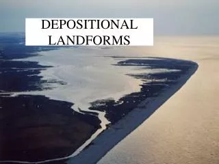
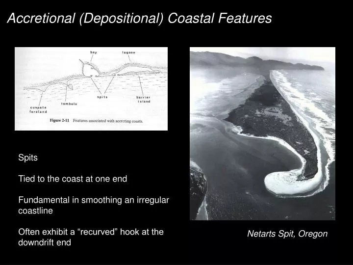
Accretional (Depositional) Coastal Features. Spits Tied to the coast at one end Fundamental in smoothing an irregular coastline Often exhibit a “recurved” hook at the downdrift end. Netarts Spit, Oregon. Examples of Spit Growth.

E N D
Accretional (Depositional) Coastal Features Spits Tied to the coast at one end Fundamental in smoothing an irregular coastline Often exhibit a “recurved” hook at the downdrift end Netarts Spit, Oregon
Examples of Spit Growth Geomorphic history of Fire Island, NY - from aerial photography - growth in direction of L.S.T. Older hooks reflect paleo- spit ends Spit growth can deflect the course of a river
Occur where spit growth extends to an offshore island Island often influences wave field - refraction Italian term, where they are numerous and well-developed Tombolos see Figure 2.16 in Komar
World class example: Outer Banks, NC Mechanism of formation is debated: 1. Form at points of LST convergence from 2 directions? 2. May have a geologic control? Cuspate Forelands / Capes
Occur along 13 % of the world’s shorlines Prevalent in areas of small tidal range = 1-2 meters Barrier Islands
set up slope of substrate, rate of sea level rise, retreat rate of barrier island washover mechanics Blackboard Example: barrier island migration
Regressive vs. Transgressive Sequences Rooted in Walther’s Law Regressive Sequence - Landward sediments are deposited on top of seaward seds, reflect a seaward shift of shoreline. Transgressive Sequence - Seaward sediments are deposited on top of landward seds, reflect a landward shift of shoreline. Not necessarily diagnostic of SL rise or fall - think about sediment supply.
Hoyt (1967) - sand dunes drowned in place by relative SL rise de Beaumont (1845) - cross-shore sed. transport, from an excess, “traps” a lagoon. Gilbert (1885) - Longshore sediment transport downdrift of a headland, or inlet, forms spits, that are occasionally breached. (aside on inlets, tidal prisms, and ebb tidal deltas) 3 “models” not mutually exclusive - D.J.P. Swift (1968) Theories of Barrier Island Formation
Inlet Dynamics: Spit Growth to Equilibrium Length • Thought to be controlled, in part, by tidal prism: • Within each tidal cycle, a “prism” of water must be moved into, and out of, the bay. • Spit extends freely until tidal currents, through narrowing inlet, disallow longshore transport - tidal currents generate shear stress sufficient to block longshore sediment transport. • Sediment “sinks” are the flood tidal and ebb tidal shoals (deltas)
Inlet SpacingRelated to sediment supply / distance from source Near the sediment source (eroding headland, river mouth, etc.), inlet spacing is wide. Flood and ebb-tidal shoals are a net sink for sediment, LST rate decreases downdrift. At the distal end of the barrier island system (relative to source), inlet spacing becomes close, due to decreased LST rate
Ubiquitous Landforms, without a clear explanation of their formation, preservation, and evolution. One clear requirement – sediment supply. Rink & Forrest (2005) combined OSL dating with Brooks (1972) RC dates to establish land accretion rate from beach ridges to be ~135 m/century Examine numerous beach ridge sets through google earth. Beach Ridge Sets
Beach Ridge Generation by Changes in Wave Climate & Sediment Supply St. Vincent Island, Apalachicola Delta, FL