Download
1 / 66
660 likes | 837 Views
Ground Water and Karstic Areas. GLY 2010 – Summer 2014 Lecture 19. 1. Ground Water. Ground Water is found beneath the earth’s surface It is found in two different zones: Vadose Zone Water Table Phreatic Zone Gravity carries water from the surface downward. 2.

E N D
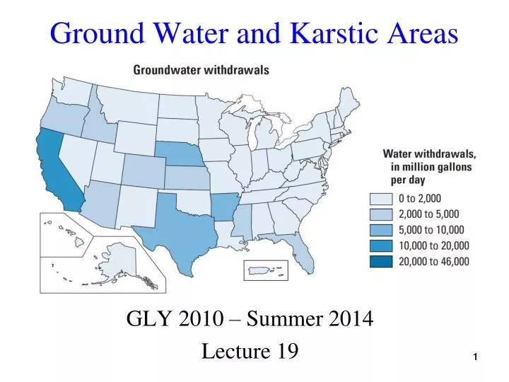
Ground Water and Karstic Areas GLY 2010 – Summer 2014 Lecture 19 1
Ground Water • Ground Water is found beneath the earth’s surface • It is found in two different zones: • Vadose Zone • Water Table • Phreatic Zone • Gravity carries water from the surface downward 2
Vadose Zone - Zone of Aeration • Some is used by plants • Some evaporates • Some is absorbed by soil particles • The remainder continues past the water table • In this zone, much of the available pore space is filled with air - Only a fraction is occupied by water 3
Water Table Fluctuations • Water table follows the contour of the surface above it, but the water table is not confined to being below the ground 5
Phreatic Zone - Zone of Saturation • In this zone, all available pore spaces are filled with water • This zone extends downward from the water table for some distance, generally less than a kilometer, because bedrock below this depth contains no pore spaces in most cases 6
What is Groundwater Used For? • Thermoelectric power 510 Mgal/day (0.6%) • Mining 1,020 Mgal/day (1.3%) • Livestock 1,290 Mgal/day (1.6%) • Aquaculture 1,910 (2.4%) • Industrial 3,070 Mgal/day (3.9%) • Domestic Use 3,740 Mgal/day (4.7%) • Public Water Supplies 14,600 Mgal/day (18.3%) • Irrigation 53,500 Mgal/day (67.2%) • Total 79,600 Mgal/day Mgal/day = Million gallons per day
Current Groundwater Levels • Link to current GW information on Google earth: http://groundwaterwatch.usgs.gov/rtn/dws_maps/GoogleEarth/us_rtn.kmz This is a real-time net with data transmitted every 1-4 hours Static image from 7-16-14
Icebergs As a Source of Water • Although thought is being given to using icebergs as a source of water, there are problems, including danger in shipping lanes, and potential climate change Iceberg Calving in Antarctica 9
Porosity • The relative volume of pore (empty) space in a rock or sediment • It determines how much water the rock or soil can hold White spaces are “pore” (empty) spaces 10
Porosity • Primary porosity in rocks is the pore space that develops when the rocks form • Examples include the space between grains in lithified clastic rocks, or vesicles in extrusive igneous rocks • Secondary porosity develops after the rock forms, as the result of fracturing or dissolution 11
Permeability • The ability of a rock or sediment to allow a fluid (water) to flow through it • Permeability is greatly influenced by the connectiveness of the pore spaces 13
Aquifer • An aquifer is a layer(s) of rock or sediment from which fresh water may be obtained in quantity • The word comes from the Latin for “to bear water” • The best aquifers are porous and permeable, with adequate recharge 14
Use of Aquifers • Modern agricultural methods put heavy demands on water systems to supply the water needed to grow food and other crops 15
Unconfined Aquifers • No impermeable layer above them • They are subject to rapid recharge from above, but may also be easily contaminated by spills, especially if they are shallow • Most water supplies come from unconfined aquifers 16
Ogallala Aquifer • The Ogallala Aquifer underlies approximately 225,000 square miles • A major unconfined aquifer 17
Aquiclude • Impermeable layers which prevent or greatly slow the flow of a fluid • Clay layers are often aquicludes • Artificial clay layers are used to line landfills, so that water from the landfill won’t leach into the aquifer 18
Confined Aquifers • Confined aquifers have aquicludes above, and sometimes below, them • Less subject to pollution than unconfined aquifers • May transport water for long distances • The Dakota Sandstone, which originates in the Black Hills of western South Dakota, supplies water to much of the Dakotas and eastern Nebraska 19
Artesian Well • Wells drilled into a confined aquifer may lie at lower elevation than the recharge region of the aquifer 20
Artesian Well Photo • Water is virtually squeezed to the surface by underground pressure • This picture shows how strong artesian pressure can be! 21
Natural Spring • Places where groundwater flows to the surface, issuing freely from the surface • Impermeable subsurface layers, or erosion of the surface, may produce a spring • Groundwater approximates the mean annual temperature in a region, unless if has been heated by a subsurface source of heat 22
Hot Springs • Thermal or hot springs are at least 6C warmer than the mean annual temperature • Such heating is usually the result of contact or proximity to magma • Found in many places, for example the Olympic, Sierra Nevada, Cascade, and Rocky Mountain ranges 23
Geysers • Intermittent hot springs, or geysers, are less common • The word geyser comes from the Icelandic word geysa, meaning to gush, or geysir, meaning to rush forth • Famous geyser fields: Yellowstone, New Zealand, northern California, and Iceland - all are associated with magma, either from subduction zones, spreading centers, or a hot spot 24
Geyser Eruption, Step 1 • Magma or hot rock heats groundwater in caverns • Water does not boil because of pressure 25
Geyser Eruption, Step 2 • Hot water rises, pressure is reduced • Water begins to boil 26
Geyser Eruption, Step 3 • Steam pushes water out of caverns as eruption starts • Pressure is reduced, water boils furiously, and eruption continues until most water is gone 27
Old Faithful Geyser • Video of geyser erupting (with sound) 28
Geothermal Energy and Pollution Geothermal fluids are often contaminated with salts, because hot water is an excellent solvent, and brings dissolved salts with it to the surface The Svartsengi Geothermal Plant, Iceland; swimming in the Blue Lagoon 32
Environmental Problems • Numerous environmental problems are associated with the use of groundwater, and the use of thermal water (geothermal) energy sources 33
Conditions for Cone of Depression Formation • Rapid withdrawal of fluid from a well causes a localized lowering of the water table around the well • May temporarily lower water below the bottom of the well, making further pumping impossible • Most likely to occur in aquifers where horizontal flow rates are low
Well Drawdown • Wells are drilled into an aquifer • Water is redrawn at a rate higher than the natural recharge rate • Result: water table is lowered • If continued, this will eventually make the well field unusable 36
Aquifer Pollution • Effluent from the septic tank field seeps into the well field 37
Subsidence • Lowering the water table (or withdrawal of other fluids, such as petroleum) can cause the collapse of pore spaces in underlying rock or sediment, and the resulting collapse of the surface 39
Subsidence Animation • Data from satellite imagery over Pomona, California from June, 1992-January 1999 • Subsidence due to water pumping • Red = subsidence • Blue = inflation 40
Subsidence Continued • This has happened in several localities: • Las Vegas - more than a meter • New Orleans - more than 2 meters • Venice, Italy - more than 3 meters, leading to frequent flooding • Mexico City - more than 7 meters • Central Valley, California - more than 8 meters 41
Salt-water Encroachment • Coastal areas face another form of pollutant in their ground water - salt-water • Salt-water is about 5% denser than fresh water • In coastal areas, the freshwater floats like a bubble on top of the salt-water • If the fresh water is over pumped, the size of the fresh water bubble decreases, and the salt-water rises (principle of isostasy) 42
Salt-water Encroachment • If salt-water rises high enough to invade the water-supply wells, they are permanently destroyed • One of the functions of the water management district is to monitor salt-water levels, and regulate fresh water withdrawal, so that salt-water does not further encroach on fresh water wells 43
Karst • Ground water is capable of dissolving limestone layers, and creating cavities which slowly enlarge • These cavities may cause environmental problems • These cavities may form caverns, sinkholes, and disappearing streams • Named for the Karst, Slovenia (part of the former Yugoslavia) region wherethey were first described 44
Dissolution of Limestone Underground • When limestone is dissolved, the weight of overlying rock and sediment pushes down • If the cavity is full of water, it may be strong enough to bear the weight • If the cavity gets bigger, or water is removed by lowering of the water table, collapse is possible • Such collapse is rapid 45
A sinkhole is created Sinkholes are commonly found in broad areas underlain by fractured limestone Sinkholes 46
Central Florida Karst • Black regions are water in sinkholes
Florida Karst • Central Florida, in the area around Gainesville and Ocala, is another karstic region • A very large sinkhole occurred in Winter Park, Fl. After a prolonged drought in 1981 Winter Park, Florida 48
Winter Park Sinkhole Close-up • Photograph by A. S. Navoy • Sinkhole developed in one day 49
Florida Sinkholes • Sinkholes are most common when the non-limestone cover above limestone is 30-200’ thick (reddish color on map) 50