Download
1 / 45
450 likes | 536 Views
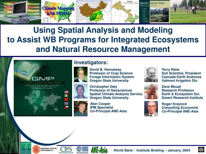
Using Spatial Analysis and Modeling to Assist WB Programs for Integrated Ecosystems and Natural Resource Management. Investigators:. David B. Hannaway Professor of Crop Science Forage Information System Oregon State University. Terry Rahe Soil Scientist, President

E N D
Using Spatial Analysis and Modeling to Assist WB Programs for Integrated Ecosystems and Natural Resource Management Investigators: David B. Hannaway Professor of Crop Science Forage Information System Oregon State University Terry Rahe Soil Scientist, President Cascade Earth Sciences Valmont Irrigation Div. Christopher Daly Professor of Geosciences Spatial Climate Analysis Service Oregon State University Dave Mouat Research Professor Earth & Ecosystem Sci. Desert Research Institute Alan Cooper IPM Specialist Co-Principal ANE-Asia Roger Kraynick Consulting Economist Co-Principal ANE-Asia World Bank / Institute Briefing – January, 2004
How we got here • 20+ years of collaboration with PRC • Extensive international experience • Briefing idea from the WB / WBI sponsored grassland workshop in Lanzhou, Gansu Province, China (breakout theme groups identified the need for geospatial analysis for developing sustainable system solutions) “Strategies and Policies for Sustainable Grassland & Livestock Management Systems” World Bank / Institute Briefing – January, 2004
Common objectives for developing sustainable systems • The World Bank • Working to make development sustainable. • Ensuring that actions taken today to promote development and reduce poverty do not result in environmental degradation or social exclusion tomorrow. • Our Group • For agriculture and natural resource management …. seeking to utilize plant, animal, soil, and water resources in the most-productive, yet non-damaging manner. • Together • Identifying and working within the biophysical and socio-economic constraints to optimize sustainable use of natural resources for the benefit of people. World Bank / Institute Briefing – January, 2004
How do we: Adapt? Modify? Magnify? Substitute? Rearrange? Combine? Purpose: • Discuss our philosophy and capabilities which involve spatial and integrated solutions to solve sustainability problems. • Present ideas for collaboration with World Bank programs and projects. World Bank / Institute Briefing – January, 2004
Outline: • Principal issues and concerns • Philosophy of a spatial, integrated approach • Elements of approach • PRC example • Collaboration potentials • Demonstration projects • Summary World Bank / Institute Briefing – January, 2004
Principal issues and concerns China is acutely aware of land degradation - occurring as a result of non-sustainable resource development, especially in the arid and semiarid west and northwest World Bank / Institute Briefing – January, 2004
New technologies can help develop and implement sustainable management strategies by defining: the biophysical state and potential of regions the suitability of various crop and livestock systems the socio-economic viability of these systems To implement this philosophy: We integrate geospatial data products for climate, soils, and plant species suitability with decision support tools and futures assessment to solve sustainability problems. Approach philosophy World Bank / Institute Briefing – January, 2004
What are the future consequences of today’s policies and land use decisions? How might we plan for a sustainable future? What might those future landscapes look like and what are the impacts of the futures on societal values? Are there futures that will result in a greater likelihood of land use sustainability? How might we achieve them? What should the roles of the communities and other local stakeholders be in terms of envisioning these futures? Planning for the future World Bank / Institute Briefing – January, 2004
Planning for the future World Bank / Institute Briefing – January, 2004
Mapping of topography, climate, and soils precipitation, temperature pH, depth, drainage, salinity, alkalinity Species suitability mapping quantitative tolerances to biophysical factors intended use and management level use of internet map server to define tolerances Validation expert evaluation field testing Socio-economic factors exploring spatial economic analysis alternative futures scenarios (community input) Delivery systems and DSS web-based and knowledge-based target audience including land managers and policy makers Professional development / capacity building students and professionals exchange programs Elements of approach World Bank / Institute Briefing – January, 2004
An example: … grass species suitability mapping in the PRC Oregon State University and Chinese cooperators: identifying suitability zones for selected forage, soil conservation, and turf species. This has involved… • Cooperation with governments, universities, agencies, and organizations • Finding and assembling necessary data • Creating GIS layers • Combining spatial data layers according to quantitative species tolerance “rules” World Bank / Institute Briefing – January, 2004
Mapping of topography, climate, and soils: Digital Elevation Model (GTOPO 30, 1 km resolution) World Bank / Institute Briefing – January, 2004
Generates gridded estimates of climatic parameters Moving-window regression of climate vs. elevation for each grid cell Uses nearby station observations Spatial climate knowledge base (KBS) weights stations in the regression function by their climatological similarity to the target grid cell Mapping of topography, climate, and soils: PRISM-based Climate Maps PRISM: Unique climate modeling software Parameter-elevation Regressions on Independent Slopes Model World Bank / Institute Briefing – January, 2004
PRISM: Parameter-elevation Regressions on Independent Slopes Model PRISM knowledge based system accounts for spatial variations in climate due to: • Elevation (digital elevation grid) • Terrain orientation (topographic facet grid) • Terrain steepness (terrain profile grid) • Moisture regime (storm trajectory grid) • Coastal proximity (coastal trajectory grid) • Inversion layer (inversion height grid) • Long-term climate patterns (climate grid) World Bank / Institute Briefing – January, 2004
PRISM Moving-Window Regression Function Stations Target grid cell World Bank / Institute Briefing – January, 2004
Official 1961-90 Precipitation Maps for the USDA NRCS Each state peer-reviewed Seamless coverage Used in thousands of applications World Bank / Institute Briefing – January, 2004
SCAS International Climate Mapping All maps are state-of-the-art, and are used as the standard for evaluation of other methods Mongolia Western Canada European Alps China Taiwan Pacific Basin World Bank / Institute Briefing – January, 2004
Data from climate stations: Precipitation (monthly and annual) Temperature (monthly and annual minimum and maximum) Others Mapping of topography, climate, and soils: PRISM-based climate; 4 km grid cell resolution 2,600 stations • Development sequence: • 30-year mean climatology • Monthly time series • Daily mapping • Example applications: • Degree-Day/Growing season • Growth/development models • Water supply • Climate trends and variability World Bank / Institute Briefing – January, 2004
Mapping of topography, climate, and soils: Mean Annual Precipitation World Bank / Institute Briefing – January, 2004
Mapping of topography, climate, and soils: January Mean Minimum Temperature World Bank / Institute Briefing – January, 2004
Mapping of topography, climate, and soils: July Mean Maximum Temperature World Bank / Institute Briefing – January, 2004
Data from most recent soil survey via cooperation with CAAS-SFI in Beijing National surveys and mapping are 1:4,000,000 CAS Soils Institute in Nanjing is completing 1:1,000,000 scale Challenge of different systems (Chinese, Russian, FAO, USA) USA national and county digital soil surveys (STATSGO and SSURGO) are 1:250,000 and 1:24,000 scale CAAS Soil & Fertilizer Institute http://www.ftw.nrcs.usda.gov/order.html Mapping of topography, climate, and soils: Soil Maps World Bank / Institute Briefing – January, 2004
Mapping of topography, climate, and soils: Soil pH World Bank / Institute Briefing – January, 2004
Species suitability mapping:Species Tolerances Database • Traditional approach has been qualitative • Need quantitative approach to work with spatial data layers and integrate with crop simulation models • Initial estimates have been developed and mapped (USA first, then PRC) • Internet Map Server for web-based improvements via “dynamic mapping” Historical qualitative, static approach. Current quantitative, dynamic approach. World Bank / Institute Briefing – January, 2004
Species Max. Temp (°C) Min. Temp. (°C) Annual Precipitation (mm) Well Adapted Tall Fescue 22 - 32 -10 625 Orchardgrass 22 - 31 -7.5 625 Perennial Ryegrass 22 - 30 -5 625 Moderately Adapted Tall Fescue 20 - 34 -15 450 Orchardgrass 20 - 33 -12.5 490 Perennial Ryegrass 20 - 32 -10 525 Marginally Adapted Tall Fescue 18 - 36 -20 300 Orchardgrass 18 – 35 -17.5 375 Perennial Ryegrass 18 - 34 -15 450 Species suitability mapping: Quantitative Climate Tolerances World Bank / Institute Briefing – January, 2004
Species suitability mapping: Internet Map Serverhttp://mistral.coas.oregonstate.edu/forages/ World Bank / Institute Briefing – January, 2004
Species suitability mapping: Internet Map Serverhttp://mistral.coas.oregonstate.edu/forages/ World Bank / Institute Briefing – January, 2004
Species suitability mapping: Festuca arundinacea World Bank / Institute Briefing – January, 2004
Species suitability mapping: Gansu Province Annual Precipitation World Bank / Institute Briefing – January, 2004
Species suitability mapping:Gansu Province - Festuca arundinacea(based solely on climate; rainfall and temperature) World Bank / Institute Briefing – January, 2004
Validate with field-based evaluation trials Link advanced technologies with traditional approaches Enlist local experts to assist with concept development, implementation, and validation Validation World Bank / Institute Briefing – January, 2004
Choices made by people, communities, societies related to: Demographics Societal values Land-use practices Land tenure issues Financial income and risk Distribution of income and wealth Socio-economic factors World Bank / Institute Briefing – January, 2004
Purpose: to enable users to assess tradeoffs between: Private Economic Decisions only vs. Joint Private – Public Planning (without planning/management) (with participatory management) Criteria: a. Demographic choices (stay in grazing or opt out) b. Land tenure (develop clear assignment of grazing rights; e.g. USA Taylor Grazing Act) c. Assess alternative financial outcomes (high risk or moderate to low risk) d. Improving social qualities of region (poorly distributed incomes and poverty vs. more equitable distribution of non-degraded resources and higher total incomes) Economic and social assessment component World Bank / Institute Briefing – January, 2004
Delivery systems and DSS : Web Segment Individual pieces are important, nevertheless: • For truly helpful product, these pieces need to be integrated into an easy-to-use Decision Support System • Web-based DSS provide easy access in an efficient delivery tool for farmers and policy makers leading to sustainable systems World Bank / Institute Briefing – January, 2004
Team and capacity building: Computer infrastructure Conferences & workshops Visiting scholars Collaborative research projects Degree programs Scientific exchange programs Short-term (weeks to months) Long-term (months to years) Professional development / capacity building: Extension and Student Education Programs World Bank / Institute Briefing – January, 2004
Collaboration potentials • UNCCD / CCICCD • USTDA / SFA • Pastoral Development (GEF / WB) • Gansu Demonstration Project • Other regions and countries Gansu Desert Control Research Institute SE Asia: Vietnam, Cambodia, Laos, Thailand Asia: Afghanistan, India, Iraq World Bank / Institute Briefing – January, 2004
Title: United Nations Convention to Combat Desertification Description: The United Nations Convention to Combat Desertification (UNCCD) defines desertification as “land degradation in arid, semi-arid, and dry subhumid areas resulting from various factors including climatic variations and human activities…” The UNCCD further suggests that “combating desertification includes activities that are part of the integrated development of lands in those areas for sustainable development.” Related projects: World Bank / Institute Briefing – January, 2004
Title: China’s CCICCD Description: China’s Committee for the Implementation of the Convention to Combat Desertification (CCICCD), which is housed within China’s State Forestry Department, is one of the more active National programs within the Convention. Related projects: Indeed, the Convention looks to the CCICCD for both guidance as well as evidence of effectiveness in carrying out the program of the Convention. World Bank / Institute Briefing – January, 2004
Title: Controlling sandstorms and desertification in areas surrounding Beijing using irrigated agriculture Description: This project demonstrates that vast areas of sandy lands can be allowed to recover naturally if a small percentage of the area is managed under modern irrigated agriculture. This practice limits overgrazing of the native grasslands and provides a sustainable source of forage for livestock production, decreases soil erosion and desertification, and reduces dust storms. Cooperators: US Trade Development Agency Valmont Industries, CES, OSU PRC State Forestry Administration Related projects: USTDA / SFA, Inner Mongolia World Bank / Institute Briefing – January, 2004
Sustainable development programs require information about biophysical constraints and socio-economic issues. Geospatial data layers are needed, integrated into Decision Support Systems (point-based information is not adequate). Climate is fundamental (the PRISM climate modeling system). Soils information must be globally interchangeable. Species environmental tolerances must be quantitative. Economic information must be linked to appropriate production models. Societal issues are addressed within community-based planning and implementation. International collaboration is essential. Participatory management of natural resources must be holistic and integrated. “Reversing land degradation and alleviating poverty go hand in hand. Both involve improving food security, educating and training people, strengthening the capacity of local communities, and mobilizing non-governmental organizations.” UNCCD Relevance to World Bank / World Bank Institute World Bank / Institute Briefing – January, 2004
Designed to: Build local knowledge and capacity Involve community, local, and regional input Plan for the future using alternative futures methodology Create decision support tools for policy development and management strategies involving spatially-based models Implement efficient and sustainable forage/livestock production systems Increase productivity and decrease poverty Extend successes to other communities Demonstration projects World Bank / Institute Briefing – January, 2004
Demonstration projects Example: • Local collaborators: e.g. Gansu Desert Control Research Institute, Gansu Agricultural University, CAS’ Cold and Arid Regions Environmental and Engineering Research Institute • Representative range / pastoral study area • Compilation, assessment, and integration of spatial information to identify appropriate crop / range species and carbon sequestration • Appropriate irrigation strategies • Community, local, regional input for alternative future scenarios and land-use options • Use of user-friendly decision support tools for building local capacity World Bank / Institute Briefing – January, 2004
Many National, Regional, and International ‘Players’ World Bank / Institute Briefing – January, 2004
Creating “the best maps” for climate, soil, species, economics, and social factors. Developing “alternative futures” scenarios that illustrate medium-term and long-term consequences of action or non-action. Integrating these maps and alternative future scenarios into a web-based Decision Support System that is scientifically accurate, up-to-date, and easy-to-use. Working together globally to accomplish these objectives to ensure greater efficiency and greater understanding of each other around the world. Future Vision Alternative Futures: Decisions to Influence the Future Must Come Now World Bank / Institute Briefing – January, 2004
Summary • Philosophy of a spatial, integrated approach: New technologies can help develop and implement sustainable management strategies. • Elements of approach • Alternative futures • Mapping of topography, climate, and soils • Species suitability mapping • Validation • Socio-economic factors • Delivery systems and DSS • Professional development / capacity building • PRC example • Grass species suitability mapping • Collaboration potential • UNCCD/CCICCD; USTDA / Valmont; Pastoral Development • Demonstration project • WB / WBI, Gansu Province, PRC SFA, and other cooperators World Bank / Institute Briefing – January, 2004