Download
1 / 51
580 likes | 1.11k Views
Latitude. The equator is the reference line. Latitude is an Angular Distance. Lines of Latitude are Parallels. Finding Latitude Using the Altitude to Polaris. Altitude The angular distance of any celestial object above the horizon.

E N D
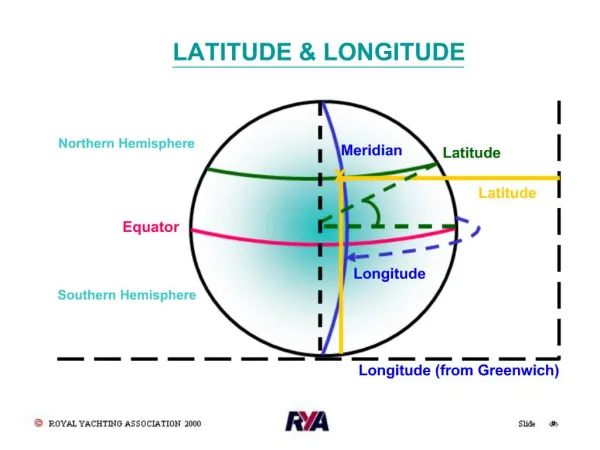
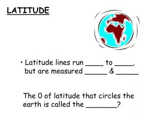
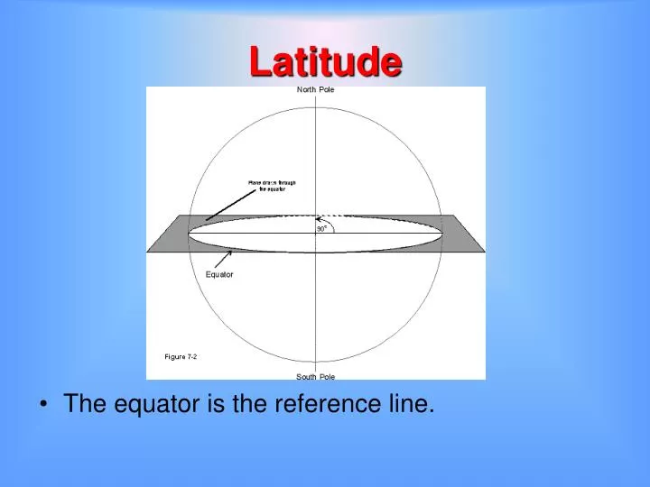
Latitude • The equator is the reference line.
Finding Latitude Using the Altitude to Polaris • Altitude • The angular distance of any celestial object above the horizon. • This is the angle between an observer’s line of sight and the horizon. • The maximum altitude of any object is 90o. • Directly above the observer. • Called the zenith.
Altitude of Polaris 90 o 90 o
Altitude of Polaris 60o 60 o
Altitude of Polaris 30o 30o
Finding the South Pole of the Sky using the Southern Cross • The Southern Cross is used to find south. It has five stars. • Visualize a line extending from the long axis. • You can find south by estimating a distance that is about five times that of the two pointer stars along that line. You can also estimate this distance by using three hand widths as shown in the illustration. South is below the south pole of the sky.
Finding the South Pole of the Sky using the Southern Cross • You can also imagine a line connecting the two pointer stars. • Divide this line in half and then visualize another line extending at 90o. • Extend an imaginary line extending from the long axis of the Southern Cross. • The two lines will meet in the approximate position of the south pole of the sky.
Longitude • Measured east or west of the Prime Meridian
The Prime Meridian • Reference line for longitude • Runs north-south through the Royal Observatory in Greenwich, England • Established at the International Prime Meridian Conference • October, 1884 in Washington, D.C. • France didn’t adopt it until 1911 The Royal Observatory in Greenwich, England
Longitude • Angular Distance East or West of the Prime Meridian
Meridians • Half Circles • Trend North to South • Converge at the poles. • True North is where meridians converge at the north geographic pole/
Magnetic North is not the same as True North • Magnetic North is the direction in which Earth’s magnetic lines of force converge
Magnetic North • Magnetic North is not in the same location true north and moves 10 to 40 km per year • It’s currently about 1,000 km from the true North Pole, in Hudson Bay, Northern Canada (at 82.7o N, 114.4o W in 2005).
Compasses Are Unusable Near the North Pole • The horizontal force of the magnetic field • Responsible for the direction in which a compass needle is oriented • Decreases in strength as it approaches the North Magnetic Pole, where it is zero. • Close to the pole, an area is reached where the frictional forces in the pivot are comparable to the horizontal forces of the magnetic field. • The compass starts to behave erratically • Eventually, as the horizontal force decreases even more, the compass becomes unusable
Magnetic Declination • The difference in degrees between magnetic north (indicated on a magnetic compass) and true north. • Because magnetic north is continually changing, this is good only for the year of the map.
Magnetic Declination West Declination East Declination Agonic Line (No Declination)
Tropic of Cancer (23.5o N) Equator Tropic of Capricorn (23.5o S) Prime Meridian 50oS, 75o W
Earth’s Rotation • Earth spins on it’s axis, the imaginary straight line through Earth between the North Pole and the South Pole • The axis of rotation is inclined 23 ½ degrees from a perpendicular to the plane of Earth’s orbit.
Rate of Earth’s Rotation • Earth makes one complete turn from west to east every 24 hours. • Angular Rate of Rotation: One complete rotation is equal to 360 degrees in 24 hours or 15o/hr.
Night Day As you travel west to east, time is later
Time Zones of the World • Time Zones cover 15 degrees of longitude • There is a one hour time change for every 15 degrees (time zone)
Standardizing Time • Many observations are given in terms of time at the Prime Meridian which is referred to as: • Greenwich Mean Time (GMT) • Zulu Time (Z) • Universal Coordinated Time (UTC)
The International Date Line • Approximated by the 180o meridian • Adjusted to pass around islands • When crossed the calendar date changes • When crossed from west to east • One is subtracted from the calendar date • When crossed from east to west • One day is added to the calendar date • The sun time is unchanged Friday Thursday International Date Line
Expressing Time • The 24-hour Clock • Begins at midnight and ends 24 hours later • Hours and minutes • 7:30 a.m. • 07h25m or 0725 • 3:15 p.m. • 1515 • 12 noon • 1200
What is Noon and Midnight? • Noon • 1200 hours • p.m. starts after this at 12:00:01 • Midnight • 0000 hours • a.m. starts after this at 00:00:01
Finding Time • The difference in Sun Time • 15 degrees of longitude corresponds to a time difference of one hour • Take the difference in longitude between two locations and divide by 15o
Example 1 • Find the time in Denver if the time at Greenwich is 1400 • Longitude of Greenwich is 0o • Longitude of Denver is 105o West • Difference in longitude is 105o • 105o/15o = 7 hour time difference • Denver is west so it’s earlier than Greenwich • Time at Denver is 0700
Problem (Lab p.6) • Location A has a longitude of 135o W and location B has longitude of 32o E. • If the “Sun” time at A is 1735 (5:35 p.m.) on March 10, what is the “Sun” time and date at location B.
Problem (Lab p.6) • Step 1 • Determine the smallest difference in longitude between the two locations.* • 135o + 32o = 167o 135o W 32o W • *Traveling west from 135o would be a difference of 193o • 135o to 180o = 45o and 180o to 32o = 148o • 45o + 148o = 193o
Problem (Lab p.6) • Step 2 • Find the time difference • Divide the difference in longitude by 15o • 167o/15 = 11.13 hours • Find how many minutes 0.13 hours represents by multiplying 0.13 by 60 (there are 60 minutes in an hour 0.13h x 60 min = 7.8 (8 minutes) • The time difference is 11h08m.
Problem (Lab p.6) • Determine if the time at B is later or earlier than at A • Location B is East of Location A • This makes the time a B later than at B • Add the time difference to the “Sun” time at A 11h08m + 1735 (5:35 p.m.) 1735 + 11 h takes us to 0435 (4:35 a.m.) and into the next day Add the additional 8 minutes to 4:35 a.m. • The time at B is 04h43m on the next day which is March 11.
The Statute Mile • One degree of latitude is equal to approximately 69 statute miles • A statute mile is 5,280 feet. • The term mile was first used by the Romans (statute mile for land mile). • Was about 1,000 paces • The term “Mile” is derived from the Latin Words “milia passuum” for 1,000 paces • Was defined by an act of Parliament in 1592 during the reign of Queen Elizabeth I.
The Nautical Mile • 1 arc minute of latitude = 1 nautical mile • One degree = 60 minutes = 60 nautical miles • Examples converting latitude to nautical miles . . .
Example 1 • 10 degrees of latitude = ? Nautical miles • 10o x 60 min = 600 minutes • 1 min of lat. = 1 nm • (1 min) X = (600 min)(1 nm) = 600 nm 1o 600 min X (1 min) (1 min)
Example 2 • 8o 30’ (8.5o) of latitude = ? Nautical miles • 8.5o x 60 min = 510 minutes • Ans. 510 nm 1o
Converting Statute Miles to Nautical Miles • 1 degree of latitude = 69 statute miles (mis) • Remember that 1 minute = 1 nautical mile (nm) • Therefore: 60 min = 69 mis • 1 nautical mile = 1.15 statute miles 60 nm 1nm X = (69 ms) (1nm) 69 mis X 60 nm = X = 69 mis 60 = 1.15 mis
Converting Nautical Miles to Statute Miles • 125 nautical miles is equivalent to how many statute miles? 1 nm 125nm X = (1.15 mis)(125 mn) 1.15 mis X 1 nm = X = (1.15 mis)(125) = 143.75 mis 125 nautical miles 144 statute miles
Converting Statute Miles to Nautical Miles • 144 statute miles is equivalent to how many nautical miles? 1 nm X X = (1 nm)(144 ms) 1.15 mis 144 mis 1.15 mis = X = 144 nm = 125 nm 1.15 144 statute miles = 125 nautical miles
The Knot • Unit used for the speed of a vessel relative to a fluid • Ships in water • Airplanes in air • One knot = one nautical mile per hour • Abbreviations: • kt (singular) • kts (plural) • kn (Used by the International Hydrographic Organization)
Origin of the term “Knot” • Until mid 19th century the “chip log” was used. • A wooden panel, attached to a line was cast over the ship’s stern • Knots placed in the rope, spaced at 47’ 3” passed through a sailor’s hands • Another sailor used a 30 second sand-glass to time the operation • 1 knot = 20.25 inches per second