1 / 0

Gravity and Isostasy

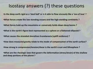
Gravity and Isostasy. OCEA/ERTH 4110/5110. Introduction to Marine Geology. 1. Basic Concepts and Data Reduction.

kirsi
Download Presentation

Gravity and Isostasy

An Image/Link below is provided (as is) to download presentation Download Policy: Content on the Website is provided to you AS IS for your information and personal use and may not be sold / licensed / shared on other websites without getting consent from its author. Content is provided to you AS IS for your information and personal use only. Download presentation by click this link. While downloading, if for some reason you are not able to download a presentation, the publisher may have deleted the file from their server. During download, if you can't get a presentation, the file might be deleted by the publisher.

E N D

Presentation Transcript


  1. Gravity and Isostasy

    OCEA/ERTH 4110/5110 Introduction to Marine Geology
  2. 1. Basic Concepts and Data Reduction

    "After dinner, the weather being warm, we went into the garden and drank thea, under the shade of some apple trees...he told me, he was just in the same situation, as when formerly, the notion of gravitation came into his mind. It was occasion'd by the fall of an apple, as he sat in contemplative mood. Why should that apple always descend perpendi-cularly to the ground, thought he to himself..." Newton's law of gravity: Fg = G MeM/a2ge = G Me/a2 Potential field representation: Fg = - D U = - dU/dr Average gravitational acceleration = <g> ~ 980 cm/s2 = 980 Gal We want to remove this main field due to overall average mass of the earth Proceed by calculation of various gravity anomalies from surface observations
  3. (1) Correction for Spheroid: dependency on latitude Variation of g with latitude on rotating earth: Spheroid is mathematical representation of rotating homogeneous fluid r= a cos Ф; ω = rate of earth’s rotation; φ = latitude Fc = Centrifugal Force = m ω2 r = m ω2 a cos φ Fr = component of Fcin radial direction (same direction as Fg) = Fc cos φ = m ω2 a cos2 φ <αr>max = <Fr/m>max ≈ 5 gal This force results in deformation of a spherical “non-rotating” earth into a rotating oblate spheroid, where ae (equatorial radius) is larger than ap (polar radius). If (ae + ap)/2 = 6371 km ae - ap ≈ 21 km gequator ≈ 978 gal gpole ≈ 983 gal Resulting Formula is: Anomaly is what remains once we remove this effect due to rotation: D g = gobs - gs
  4. (2) Free-Air Anomaly (FAA): correction for height above sea-level If measurement is made at height h above sea-level, then Since g = G Me/a2 Free-air anomaly: gFA = D g + 0.308 h h Sea-level Measuring gravity acceleration on a mountain top
  5. (3) Bouguer Anomaly: Attraction of additional mass above sea-level that is NOT accounted for by FA correction Bouguer Anomaly: gBoug = gFA - gB gB ≈ 41.9 ρ h (mgal); if h (in km) and ρ (in g/cm3). For oceans, the anomaly is calculated by filling in the water layer with rock In this case, the density used (-1.7 g/cc) is the difference between water (1.0 g/cm3) and typical rock (2.7 g/cm3). Given a water layer of 5 km and assuming that gFA= 0 then gBA=0-(-1.7)(5)(41.9) = +356 mgal.
  6. (4) Geoid and Gravity The geoid represents the true equipotential surface of the earth. In the oceans, this surface is sea-level since water has no strength and any deviation from an equipotential surface will produce a force acting on the surface. We can measure the geoid by measuring the time it takes to reflect a radar pulse from a satellite off the earth’s surface (just like measuring water depth from echo sounders), given that we know the orbit of the satellite from tracking stations and any corrections due to variations in the speed through the atmosphere. This is referred to as satellite altimetry. The geoid will be different than the surface of the spheroid given that the earth contains more complex density variations than a simple rotating fluid. We therefore can consider two surfaces ΔN = Geoid Anomaly = distance between observed geoid and the reference spheroid (in metres). ΔU = potential anomaly between these two surfaces = Umo - Uo Thus, ΔU ≈ -go ΔN and since Thus, from the derivative of the observed geoid we can calculate the gravity anomaly gp.
  7. Fig. 1 Long-wavelength features of the EGM96 geoid model relative to the WGS-84 reference ellipsoid. Maximum height (red) is ~ 85 m; minimum height (magneta) is ~ −107 m. For a more detailed model see http://earth-info.nga.mil/GandG/images/ww15mgh2.gif. Fig. 2 Determination of geoid by satellite observations. Because the geoid is the actual equipotential surface of the Earth (relative to the reference spheroid), it is the same as the sea surface elevation.
  8. Fig. 3 Free-air gravity anomalies for water covered regions of the Earth based on satellite altimetry. (resolution ~ several kms)
  9. 2a. Gravity Models Using 2-D Prisms with constant density

    examples: mid-ocean ridge and continental margin result is dominated by 2 major density contrasts: at basement and at Moho (crust-mantle boundary) Possible sub-crustal density variations require additional control from other data
  10. 1965 Fig. 4 Three possible crustal models across the north mid-Atlantic ridge which satisfy gravity anomalies. In all three models, the anomalous mantle under the ridge crest is assumed to underlie the normal mantle under the flanks of the ridge. This type of structure is not actually observed but is an artifact of the model. Instead, thermal models indicate that the low densities are caused by the cooling and thickening of the lithosphere above the asthenosphere. Thermal models suggest that these models are ALL wrong since mantle density does not stay constant
  11. Fig. 5 Interpretation of seismic and gravity data across the continental margin of earstern Canada. Note the thinning of the crust from continent to ocean used to compensate for the increase in water depth, since the free-air anomaly across the margin is small. Model indicates that crust beneath continents is much thicker than beneath oceans
  12. 2b. Gravity Models assuming Isostasy

    Local (Airy vs Pratt) Regional (Bending of Lithosphere)
  13. Airy - constant prism density; depth of prism changes (e.g. ocean-continent) Pratt - constant reference depth; density of prisms change (e.g. mid-ocean ridge) Fig. 6 Isostatic compensation according to the Pratt and Airy hypotheses. In the Airy model, the crust has a constant density (c) but changes its thickness (T); while for the Pratt model, the crustal densities (h, c, or) change and the thickness (D) stays the same.
  14. Calculation of continent to ocean crustal thicknesses in isostatic balance Isostatic Balance constant pressure (ie weight of overburden) at some specified depth. Mathematically this means that For continent-ocean example we calculate balance at points 1 (continent) and 2 (ocean) for a depth at the bottom of the model. “g” remains constant so it cancels out  if hc = 30 km and hw = 5 km, then ho = 30 – 5 (2.3/0.5) = 30 – 23 = 7 km Result indicates that depth of ocean basins also depends on thickness of crust in addition to thermal state (density) of lithosphere
  15. Regional Isostasy I: Bending of plate beneath seamounts Fig. 7 Schematic diagram showing the bending of an elastic lithospheric plate beneath a load represented by a seamount with thick crust. Note the deflection of the plate down beneath the seamount but up in adjacent regions (outer high). Hawaiian Islands Fig. 8 Gravity observations in the vicinity of the Hawaiian island chain. The bending of the plate is indicated by the moat of low gravity (purple colour) adjacent to the seamounts and an outer gravity high (yellow colour) created by the outer bulge.
  16. Regional Isostasy II Bending of plate beneath trenches Fig. 9 Schematic diagram of the bending of the lithosphere at a subduction zone (trench). Applied loads include a vertical force (Q), bending moment (M) and horizontal force (T). Note the bulge in the top boundary (w) above an equilibrium level due to the restoring buoyancy force. The elevation of the highest point wb is typically 300-500 m that creates a local gravity high. Fig. 10 Free-air gravity anomalies in the western Pacific. The bulges due to the subduction zones result in gravity highs (yellow bands indicated by arrows) seaward of the trenches.
  17. Regional Isostasy III Strength of plate linked to thermal model of lithosphere Results suggest thickness of plate vs. age follows 350-650 C isotherm Plate thickness from isostasy less than plate thickness from thermal model or seismic thickness (depth to asthenosphere) because only colder part of plate behaves elastically Fig. 11 Summary of elastic thickness of the oceanic lithosphere (Te) plotted against lithospheric age at the time of loading. The solid lines are the 350 and 650 oC isotherms based on a cooling plate model. The open symbols represent seismic estimates of the lithospheric thickness from surface wave studies. The vertical arrows schematically illustrate the relaxation of the oceanic lithosphere from its short-term (seismic) thickness to its long-term (elastic) thickness.
  18. 3. Examples of Gravity Anomalies and Plate Tectonics

  19. Gravity anomalies and buckling of plate: Region of E-W anomalies in central Indian Ocean caused by large compressive forces created with impact of India w/ Asia Fig. 12 N-S gradients of satellite-derived gravity anomalies in the northern Indian Ocean. Slopes down to the north are light; slopes up to the north are dark. The E-W-trending anomalies associated with intraplate deformation are observed in the upper left of the image as indicated. Fig. 13 N-S reflection profiles in the central Indian Ocean across the region of the E-W gravity anomalies, showing long-wavelength variations in basement topography. These variations are partially hidden by sediment deposition that fills in the basement lows. The topography has been modelled by the buckling of the lithosphere due to enhanced horizontal stresses caused by the collision of India and Asia.
  20. Carlsberg Ridge triple junction SW Indian Ridge SE Indian Ridge Gravity anomalies and presence of secondary convective cells Evidence from mid Pacific region but debate still rages as to cause of these lineations Contrasts in gravity for crust formed at mid-ocean ridges with different spreading rates Indian Ocean Triple Junction Fig. 15 Satellite-derived gravity anomalies in the SW Indian Ocean showing the evolution of the triple junction between the slow-spreading SW Indian Ridge and intermediate spreading SE Indian Ridge and Carlsberg Ridge. The slow spreading rate crust has much greater topography and is more broken up, as indicated by the higher amplitude gravity anomalies. Fig. 14 Satellite-derived gravity anomalies in the south central Pacific Ocean showing evidence for lineations (arrows) perpendicular to the trend of the East Pacific Rise (thin black lines). These lineations have been considered as possible evidence for the existence of convective rolls beneath the lithosphere, but there is still much on-going debate.
  21. Web Sites: Reading List: Sandwell&Smith, Exploring the ocean basins with satellite altimeter data Fowler, The Solid Earth, ch. 5 fowler_ch5.pdf Gravity maps derived from satellite geoid Seafloor bathymetry derived from satellite gravity
More Related