Download
1 / 13
130 likes | 207 Views
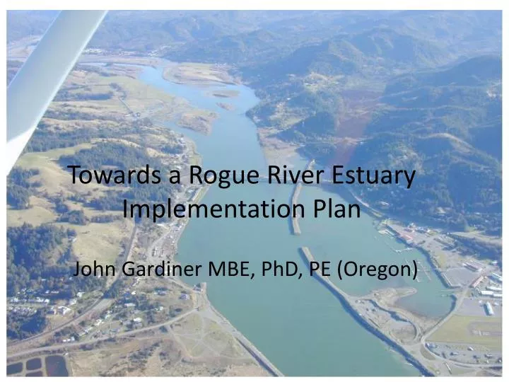
Towards a Rogue River Estuary Implementation Plan. John Gardiner MBE, PhD, PE (Oregon).

E N D
Towards a Rogue River Estuary Implementation Plan John Gardiner MBE, PhD, PE (Oregon)
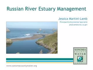
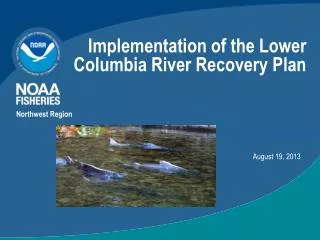
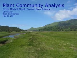
Upper Rogue River estuary with its three tributaries, with Edson Creek just out of view at the top of the photo. Note Snag Patch Slough below Saunders Creek, mainstem side channel below Edson and the floodplain of the unnamed tributary where side channel restoration is recommended.
Lower Rogue Watershed Council's Assessment (2005) ODFW estuary inventory report recommendations • Do not alter the few undisturbed intertidal and shallow subtidal habitats in the lower estuary except as part of a restoration project. Two such areas are the spit forming inside the jetties and the shore near the Coast Guard station. • Do not dredge or fill the shallow subtidal land outside the basin dike that is the area of the remnant island. • The boat basin may contribute significantly to the productivity of the estuary and more information is needed to determine if improved flushing is necessary to maintain high quality water and sediments.
A Rogue River EstuaryHydro-geomorphic Investigation • Identify & develop issues - visual inspection, community outreach, collating available information and scientific data • Articulate goals to be accomplished for an Estuary Project Implementation Plan, eg. increase depth, create fish habitat, reduce sediment input from cut banks • Identify and assess information available to formulate a Project Implementation Plan.
Identify and Engage Working Groups • Identify all interested local authorities, agencies, organizations and individuals, together with contact details of likely personnel involved • Develop working group(s) to shape and comment on the process and its recommendations
Available information on the morphological history of the estuary Conduct a data search and desk-top survey of: • aerial & land-based photographs • bathymetry records and • maps showing the river and its floodplain - as far back in time as possible (period of enquiry) and rectify to the same scale using GIS
Historic flood levels/extent; digital topographic model of the estuary • Access FEMA and other (DOGAMI etc) records of flood levels & designated floodway in digital format. • Evaluate any LiDARsurvey(s) • derive the longitudinal profile of the channel thalweg • Obtain a topographic model sufficient to build a 2-D hydrodynamic model of the estuary.
Land Ownership and Zoning in the Estuary • Procuremaps from Curry County Enterprise GIS System of current land ownership and zoning • Rectify to aerial photo base layer from 2002 or later if practicable • Identifyrelevant ordinances and land use controls or incentives
Prioritized list of initial sites for bioengineering intervention, with estimates Identify estuary erosion sites for immediate bioengineering intervention to: • re-establish riparian vegetation • prevent further sediment input • provide demonstration sites: • specific location, • photographic record, • length of treatment, • priority ranking, • initial estimate
Existing data on salmonid size/health outcomes and limiting factors: recommend initial remedial actions • Access existing and historical information on the size and health outcomes of out-migrating juvenile salmonids • Identify known limiting factors that affect health/adult return outcomes • Recommend improved outcomes.
Identify Potential Phase 2 Tasks Specify and estimate for tasks needed for Phase 2: • Identify land use activities: agriculture, road building, gravel mining, and events (eg. the Biscuit and other fires, dam decommissioning, etc…) likely to affect the Rogue River sediment budget • Analyze river morphology changes to quantify the rate of channel change over the period of record, with an analysis/plan of the meander-belt corridor • Assess current land use ordinances that exist to address excessive sediment delivery to Rogue River • Identify further investigations needed to establish or confirm • major sediment sources • likely natural or background rate of sediment transport • effects on hydrology of changing land use • estimated effects of future land use and climate change These investigations could involve the use/application of a hydrodynamic model with sediment transport modeling capability, such as MIKE 21.
Phase 2a: Recommended Actions Report for the Rogue River Estuary Carry out the investigations in Phase 1.f above, to provide: • A sediment budget from Quosatana Creek to the river mouth to identify the sources of sediment now causing problems for the Rogue estuary • A 2-D hydrodynamic model with sediment transport module • Impacts of land use activities (past and future) on the Rogue River sediment budget • Recommended policy revisions to current land use ordinances
Phase 2b: Rogue River Estuary Implementation Plan: Priority Site(s) Design, Obtain Permits and Funding for Bio-engineering Intervention to: • re-establish riparian/wetland vegetation • prevent further sediment input to the estuary • provide demonstration sites for further channel restoration planning