Download
1 / 1
10 likes | 87 Views
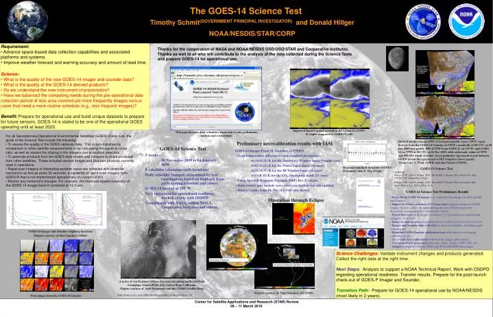
http://rammb.cira.colostate.edu/projects/goes-o. Improved Imager spatial resolution at 13.3 µm for GOES-14 (right) compared to GOES-12 (left). Web page includes daily schedules, significant events, preliminary analysis and related links.

E N D
http://rammb.cira.colostate.edu/projects/goes-o Improved Imager spatial resolution at 13.3 µm for GOES-14 (right) compared to GOES-12 (left) Web page includes daily schedules, significant events, preliminary analysis and related links. Derived product image (DPI) of total precipitable water (TPW) vapor derived from the GOES-14 Sounder (at 105W), nominally at 00 UTC on 04 Dec 2009 (top panel). DPI of TPW from GOES-11 (at 135 W) and GOES-12 (at 75W) at 00 UTC on 04 Dec 2009, with radiosonde values of TPW and 850 hPA winds overlaid. Good qualitative agreement is seen between GOES-14 and the operational GOES Sounders (lower panel). (From Gary S. Wade (ASPB) and Jim Nelson (CIMSS). Preliminary intercalibration results with IASI GOES-14 Science Test 5 weeks 30 November 2009 to 04 January 2010 8 schedules (changing earth locations) Daily schedule changed. determined by test coordinators, based on feedback from participating scientists and others GOES-14 located at 105°W Very important for operational readiness, worked closely with OSDPD Coordinated with NASA, within NOAA, Cooperative Institutes and others. GOES-14 Imager From M. Gunshor, of CIMSS - Mean temperature differences (and standard deviations): +0.14 (0.31) K for the Shortwave Window band (9 night cases) +0.81 (0.22) K for the Water Vapor band (20 cases) +0.31 (0.37) K for the IR Window band (22 cases) -0.53 (0.33) K for the CO2 Absorption band (23 cases) - Using Spectral Response Function (SRF) Rev E release. - Some results may include cases where navigation was sub-optimal. - Similar results from Dr. Wu of STAR (not shown) GOES-13 Science Test GOES-13 Hillger, D.W., and T.J. Schmit, 2007: The GOES-13 Science Test, NOAA Tech. Rep., NESDIS 125, (September), 88 pp. Hillger, D.W., and T.J. Schmit, 2009: The GOES-13 Science Test: A Synopsis. Bull. Amer. Meteor. Soc., 90(5), (May), 6-11. Operation through Eclipse GOES-14 Imager and Sounder weighting functions (Figures courtesy of Mat Gunshor/CIMSS) A series of von Karman vortices was seen streaming southward from Guadalupe Island off the west coast of Baja California. (Figure courtesy of Scott Bachmeier and the CIMSS Satellite Blog) First images from the GOES-14 Sounder The GOES-14 Science Test Timothy Schmit(GOVERNMENT PRINCIPAL INVESTIGATOR) and Donald Hillger NOAA/NESDIS/STAR/CORP • Requirement: • Advance space-based data collection capabilities and associated platforms and systems. • Improve weather forecast and warning accuracy and amount of lead time. • Science: • What is the quality of the new GOES-14 imager and sounder data? • What is the quality of the GOES-14 derived products? • Do we understand the new instrument characteristics? • Have we balanced the competing needs during the pre-operational data collection period ofless area covered yet more frequently images versus users that need a more routine schedule (e.g., less frequent images)? • Benefit:Prepare for operational use and build unique datasets to prepare for future sensors. GOES-14 is slated to be one of the operational GOES operating until at least 2020. Thanks for the cooperation of NASA and NOAA/NESDIS OSD/OSO/STAR and Cooperative Institutes. Thanks as well to all who will contribute to the analysis of the data collected during the Science Tests and prepare GOES-14 for operational use. • For all Geostationary Operational Environmental Satellites (GOES) check-outs, the goals of the Science Test include the following: • To assess the quality of the GOES radiance data. This is accomplished by comparison to other satellite measurements or by calculating the signal-to-noise ratio, as well as assess the striping in the imagery due to multiple detectors. • To generate products from the GOES data stream and compare to those produced from other satellites. These included several Imager and Sounder products currently used in operations. • Rapid-scan imagery of interesting weather cases are collected with temporal resolutions as fine as every 30 seconds, a capability of rapid-scan imagery from GOES-R that is not implemented operationally on current GOES. • Monitor any instrument changes. For example, the improved spatial resolution of the GOES-14 imager band 6 (centered at 13.3 um). Mean and standard deviation of GOES-14 Sounder bias (F. Wu, STAR) • GOES-14 Science Test Preliminary Results • First official GOES-14 images were collected from Imager (visible and IR) and Sounder • Improved (4 km) resolution of 13.3 µm band required changes to GVAR format. Several issues with implementing the new GVAR formatwere discovered, communicated, rectified, and verified. • Paired detectors on the higher-resolution 13.3 µm band were inadvertently swapped. Now fixed. • Image navigation issues (regarding moved coefficients) have been resolved. • Imager and Sounder data collected for a host of schedules, including rapid scan imagery. • Identified GOES Sounder calibration issue with respect to averaging calibration slopes. • Initial IASI inter-calibrations with both the imager and sounders. • Various products generated (retrievals, winds, clouds, CSBT, SST, etc.) • Imagery posted on both the STAR and NOAA/NESDIS home pages. Science Challenges:Validate instrument changes and products generated. Collect the right data at the right time. Next Steps:Analysis to support a NOAA Technical Report. Work with OSDPD regarding operational readiness. Transfer results. Prepare for the post-launch check-out of GOES-P Imager and Sounder. Transition Path: Prepare for GOES-14 operational use by NOAA/NESDIS (most likely in 2 years). Cloud-top Pressure (GOES-14 Imager) Cloud-top Pressure (GOES-14 Sounder) (Figures courtesy of Tony Schreiner of CIMSS) http://cimss.ssec.wisc.edu/goes/blog/archives/category/goes-14