Download
1 / 31
690 likes | 1.44k Views
http://www.realtime-products.com/. Historic Santa Fe Trail. Objectives. Students will learn the location of the Santa Fe Trail in the United States. Students will discover why the trail is important in the westward expansion in the United States.

E N D
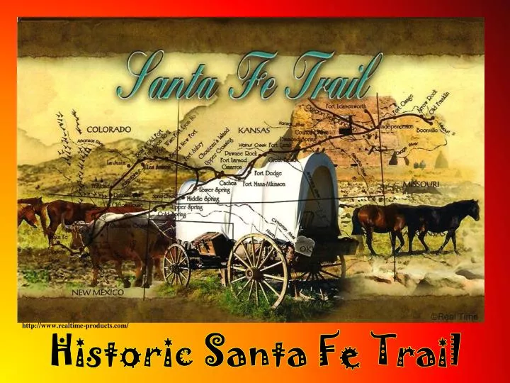
http://www.realtime-products.com/ Historic Santa Fe Trail
Objectives Students will learn the location of the Santa Fe Trail in the United States. Students will discover why the trail is important in the westward expansion in the United States. Students will understand the significance of the Cimarron Cutoff of the Santa Fe Trail which crossed the panhandle of what will become Oklahoma. Students will realize that while the Santa Fe Trail opened the door to American expansion in the Southwest, it also signaled an end to the Plains Indians’ nomadic way of life.
Once Mexico gained independence from Spain in 1821, trade was encouraged with the United States. http://www.legendsofamerica.com/we-santafetrail.html Becknell loaded manufactured goods from Missouri onto a mule train to trade for furs, gold, silver & other goods in New Mexico. By his third trip, Becknell found a passable wagon route, thus beginning the many wagon trains traveling the Santa Fe Trail. William Becknell was determined to make the trip across waterless plains & past war-like Indians to trade with the distant Mexicans in New Mexico. On September 1, 1821, he left Arrow Rock, Missouri with four companions blazing what would become the Santa Fe Trail.
http://www.legendsofamerica.com/photos-oldwest/SantaFeArmyTrain.jpghttp://www.legendsofamerica.com/photos-oldwest/SantaFeArmyTrain.jpg Soon, many traders as well as the military, were traveling the Santa Fe Trail.
Wagon ruts at the beginning of Santa Fe Trail are still visible at Ft. Leavenworth, Kansas. All photos without URLs are by Glenda Sullivan
Missouri River Santa Fe Trail All photos without URLs are by Glenda Sullivan
http://www.averyphoto.com/ Two routes developed along the trail, the Mountain Route & the La Jornada del Muerto Route, meaning the “journey of death.” Both routes followed the same path from Missouri traveling west to the Arkansas River, then followed the river into southwest Kansas.
http://www.legendsofamerica.com/we-santafetrailtales.html The steep banks of the Pawnee Fork Crossing near Fort Dodge, Kansas, made this one of the most difficult crossings on the trail.
Pawnee Rock Kansas http://www.kshs.org/pawnee_rock http://www.kshs.org/kansapedia/pawnee-rock/11905 Santa Fe Trail travelers saw Pawnee Rock reaching for the sky across the vast prairie from miles away since it was over 150 ft. tall. Hundreds stopped to carve their names in the soft sandstone next to Indian drawings that were already engraved there. This was a dangerous point on the trail since Indians used it as a lookout point to spot bison herds & approaching wagon trains.
Just beyond Fort Larned, the trail split into two branches. The Mountain Rt. was longer but not as dangerous. This branch traveled about 230 miles to Bent’s Fort near present day La Junta, Colorado, continuing to follow the Arkansas River before turning south through Raton Pass to Santa Fe. Though the shorter Jornada Route, also called the Cimarron Cutoff, provided less water, it saved the travelers ten days by cutting southwest across the Cimarron Desert to Santa Fe. www.freepages.genealogy.rootsweb.ancestry.com/~gentutor/SantaFe.gif&imgrefurl
http://www.legendsofamerica.com/we-santafetrail.html The Cimarron Cutoff was shorter and easier for the wagon parties than the Mountain Route, but travelers risked attacks by Native Americans in addition to shortage of water. Despite the hazards, the Cimarron Cutoff would end up carrying 75% of the Santa Fe Trail pioneers.
http://www.socialstudiesforkids.com/graphics/santafetrailmaplarge.jpghttp://www.socialstudiesforkids.com/graphics/santafetrailmaplarge.jpg Willow Bar is approximately 11 miles north and 11 miles east of Boise City. Here the Santa Fe Trail crossed the Cimarron River before the trail angled across the panhandle of Oklahoma. Willow Bar usually had water and was frequently used as a campsite. It was also the scene of Indian attacks and other problems.
http://www.oksenate.gov/senate_artwork/images/artwork/santa_fe_trail.htmlhttp://www.oksenate.gov/senate_artwork/images/artwork/santa_fe_trail.html Artist Wayne Cooper depicts a wagon train crossing the Cimarron River at the Willow Bar Crossing.
Headwaters of the Cimarron River The Cimarron was often without visible water, but water could frequently be found by travelers who were willingto dig in its sandy bed.
Autograph Rock at Cold Springs on the Santa Fe Trail northwest of present day Boise City still has the names that scores of travelers carved into the sandstone cliff.
Autograph Rock still has the names that scores of travelers carved into the sandstone cliff. Photo by Bob Harrelson
Because Cold Springs was a permanent water source in the panhandle, it became a major stopping point on the trail. Wagons were repaired here and livestock rested before continuing the journey. Photo by Bob Harrelson
In 1866, over 5,000 wagons carried $40 million worth of goods. http://www.averyphoto.com/ Travel on the Santa Fe Trail moved in both directions. Hispanic traders from New Mexico also headed east to Missouri.
Ruts of the Santa Fe Trail Cimarron Route are still visible today in the Panhandle of Oklahoma. Located in Cimarron County, this is the only military site on Santa Fe Trail in Oklahoma.
A Santa Fe Trail Cimarron Route marker is located in the Oklahoma Panhandle. The Santa Fe Trail is thought to be the oldest and longest commercial highway across the Great Plains. Santa Fe Trail Cimarron Route marker in Oklahoma Panhandle Ruts of the Santa Fe Trail Cimarron Route are still visible today in the Panhandle of Oklahoma. Located in Cimarron County, this is the only military site on Santa Fe Trail in Oklahoma.
Located in Cimarron County, this is the only military site on Santa Fe Trail in Oklahoma.
Rabbit Ears – Landmark on Santa Fe Trail These twin volcano peaks near Clayton, N. M., were the first two features seen by Santa Fe travelers crossing into New Mexico from present-day Oklahoma. The Cimarron Route passed about 7 miles to the north & travelers still had 200 miles to go to reach Santa Fe.
Travelers along the Santa Fe Trail often saw buffalo, antelope & big horn sheep. Photo by Marco Micozzi Photo by Glenda Sullivan Photo by Glenda Sullivan
Thistle Prickly Pear Cactus Travelers along the Santa Fe Trail often saw an array of beautiful wildflowers withcreatures like horned toads hiding among them. Yucca Horned Toad
http://mygoldrushtales.com/2011/09/20/justice-on-the-wagon-trains-2/http://mygoldrushtales.com/2011/09/20/justice-on-the-wagon-trains-2/ In 1849, with the discovery of gold in California, gold seekers traveled the Santa Fe Trail to the Gold Rush.
This sign is on the Santa Fe Trail near the Oklahoma/New Mexico border.
When railroad tracks reached Santa Fe, the “Great Prairie Highway” was no longer needed. http//lesasbookcritiques.blogspot.com
Riddles Rainbow “Threads of seven colors are stretched on the great prairie.” Creek “Runs through the valleys clapping its hands.” “Has little shoes of dirt. Whistles night and day.” Tall Grass