Download
1 / 66
660 likes | 787 Views
Modeling the Land-Atmosphere Hydrologic Cycle and its Coupling through River Flow. William J. Gutowski, Jr. Dept. Geological & Atmospheric Sciences Iowa State University. START Temperate East Asia Regional Center (February 2000). … with much help from:.

E N D
Modeling the Land-Atmosphere Hydrologic Cycle and its Coupling through River Flow William J. Gutowski, Jr. Dept. Geological & Atmospheric Sciences Iowa State University START Temperate East Asia Regional Center (February 2000)
… with much help from: Charles J. Vörösmarty2, Mark Person3, Zekai Ötles1, Balazs Fekete2 and Jennifer York3 1 - ISU 2 - Univ. New Hampshire 3 - Univ. Minnesota START Temperate East Asia Regional Center (February 2000)
Outline • CLASP - motivation - calibration/validation START Temperate East Asia Regional Center (February 2000)
Outline • CLASP - motivation - calibration/validation • Water cycle coupling through river flow START Temperate East Asia Regional Center (February 2000)
Outline • CLASP - motivation - calibration/validation • Water cycle coupling through river flow • Further directions START Temperate East Asia Regional Center (February 2000)
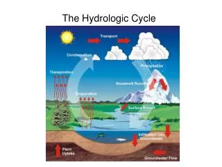
Hydrologic Cycle - Modeling Issues • Time scale mismatch • land: slow • atmosphere: fast • Spatial scale mismatch • land: small • atmosphere: large
Coupled Land - Atmosphere Simulation Program
ATMOS: • single column • computed • vertical processes • specified lateral • forcing
SVAT & SW/GW: • spatially • resolved • vertical coupling • by soil/veg • processes • lateral coupling • by river network
Application Kansas
Application FIFE - Konza Prairie, Kansas 1987-1989
Application FIFE - Konza Prairie, Kansas (from Oak Ridge DAAC FIFE page)
Boundary Conditions: • NCEP NGM analyses • 9 Years (1985-93)
Calibration/Validation (from Oak Ridge DAAC FIFE page) Observations: Betts and Ball (1998)
Calibration/Validation • 1987: Calibration • 1988 & 1989: Validation
Calibration/Validation • 1987: Calibration • 1988 & 1989: Validation • Surface: Grassland
Calibration/Validation • 1987: Calibration • 1988 & 1989: Validation • Surface: Grassland • Primary Targets: • Surface Evapotranspiration • Precipitation
Calibration/Validation: Adjustments • Precipitation • Effective RH (93.5%) • Convective precip.
Calibration/Validation: Adjustments • Precipitation • Effective RH (93.5%) • Convective precip. • Soil Moisture • Root depth (1.42 m) • Water fraction
Calibration/Validation: Adjustments • Precipitation • Effective RH (93.5%) • Convective precip. • Soil Moisture • Root depth (1.42 m) • Water fraction • “Green-up”
VALIDATION BIAS = - 48 , SDEV = 25BIAS = + 6 , SDEV = 23 [W-m-2]
VALIDATION OBS = 1.4 ; BIAS = - 0.2 ; SDEV = 5.4 [mm-d-1]
VALIDATION OBS = 2.5 ; BIAS = - 1.0; SDEV = 8.0 [mm-d-1]
VALIDATION BIAS = + 33 , SDEV = 23BIAS = - 13 , SDEV = 22 [W-m-2]
VALIDATION BIAS = + 22 , SDEV = 18BIAS = - 34 , SDEV = 41 [W-m-2]
VALIDATION BIAS = - 19; SDEV = 18 [W-m-2]
VALIDATION BIAS = - 13 ; SDEV = 7 [W-m-2]
Outline • CLASP - motivation - calibration/validation • Water cycle coupling through river flow • Further directions
Water cycle coupling through river flow • Configuration 1: • Pure grassland • No river inflow