Download
1 / 17
180 likes | 187 Views
Geospatial Semantics. Nancy Wiegand University of Wisconsin - Madison. Spatial Ontology Community of Practice (SOCoP). SOCoP was developed because of the: Recognition of the semantic interoperability component of geospatial data

E N D
Geospatial Semantics Nancy Wiegand University of Wisconsin - Madison SOCoP Dec. 2011
Spatial Ontology Community of Practice (SOCoP) • SOCoP was developed because of the: • Recognition of the semantic interoperability component of geospatial data • Realization of the potential of ontologies and formal representations to help solve semantic heterogeneity in geospatial data • SOCoP officially began in Oct. 2006 after a June meeting at the National Science Foundation SOCoP Dec. 2011
SOCoP (www.socop.org) • Membership in SOCoP is open to anyone • Conference calls are held every month, • currently on the 3rd Wednesday • at 11:00 Eastern time • Through an NSF INTEROP grant, we are • expanding SOCoP to create a larger Network • We invite those here to participate. SOCoP Dec. 2011
INTEROP – Spatial Ontology Community of Practice: an Interdisciplinary Network to Support Geospatial Data Sharing, Integration, and Interoperability NSF Program: Community-based Data Interoperability Networks (INTEROP) SOCoP INTEROP CYBERINFRASTRUCTURE SOCoP Dec. 2011
Purpose of the SOCoP INTEROP Grant Apply and develop semantic technologies for the Geospatial domain Share ontologies to promote data interoperability Submitted by 8 members of SOCoP : Gary Berg-Cross - Knowledge Strategies, Inc. Nancy Wiegand - University of Wisconsin-Madison, James Wilson - James Madison University Mike Deanand Dave Kolas – Raytheon BBN Technologies NaijunZhou - University of Maryland College Park Peter Yim - CIM Engineering, Inc. John Moeller - JJMoeller and Associates SOCoP INTEROP CYBERINFRASTRUCTURE SOCoP Dec. 2011
INTEROP Tasks - Overview • Web presence – Wiki (www.socop.org) • Workshops/meetings, in-person/virtual • Prototypes or demos • Create a geospatial ontology repository • Educational component • Basic research in geospatial data interoperability SOCoP INTEROP CYBERINFRASTRUCTURE SOCoP Dec. 2011
Web-Based Collaboration Methods http://ontolog.cim3.net/cgi-bin/wiki.pl?NsfInterop_Grant • CIM3 CWE (Collaborative Work Environment, Peter Yim) • Wiki, can put links to slides and other pages • www.socop.org • We have started to create pages here, including educational material SOCoP INTEROP CYBERINFRASTRUCTURE SOCoP Dec. 2011
Original Semantic Web Vision:Mark up Web documents and data to be machine-processable • This requires: • Additional Knowledge Representation (HTML XML, RDF, OWL) • Ontologies • Reasoners Spatial representation Spatial ontologies Spatial reasoners, Spatial rules, Spatial operators SOCoP Dec. 2011
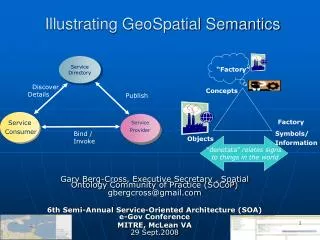
A Vision for Spatial Semantics and Ontologies • Improve search for geospatial data and services • Ontologies for semantics and background knowledge • Improve querying in geospatial data • Semantic interoperability • Combining information, Discovering new information • Role of ontologies in different geo-architectures • e.g., demos, decision-support systems, cyberinfrastructures • Geospatial data in the Linked Open Data cloud SOCoP INTEROP CYBERINFRASTRUCTURE Nancy Wiegand SOCoP Dec. 2011
Search - Geospatial One-Stop 600 results ‘River’ in ‘Dane County’
Linked Open Data Geospatial Data in the Cloud Ordnance Survey Linked Sensor Data Linked GeoData Linking Open Data cloud diagram, http://lod-cloud.net/ by Richard Cyganiak and Anja Jentzsch. SOCoP Dec. 2011
Putting Wisconsin data into RDF and (maybe) eventually into the LOD cloud D2RMap (.dbf -> RDF) Sesame (store)
Possible Workshop • Design to incorporate semantics/ontologies into computer architectures • Spatial Data Infrastructures, portals, cyberinfrastructures, information systems • Where/how do ontologies fit in? • How are they found? Remote ontologies? What component knows which ontology to use? Use of DBMS? Ontology driver for entire system? SOCoP Dec. 2011
Broaden the INTEROP Network We invite those here to participate. e.g., use cases SOCoP Dec. 2011
Thank you! SOCoP Dec. 2011