Download
1 / 18
180 likes | 323 Views
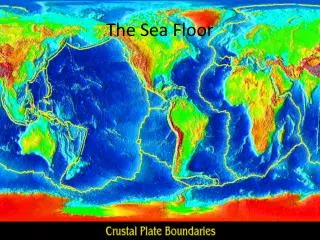
Norwegian Mapping Authority Visit. Exploring the sea floor with ROVs and AUVs. Alejandro Hinojosa CICESE. Hosting: Maritime Alliance San Dego Ca., January 16 th 2014. CICESE. Mexican government research center Located in Ensenada, Baja California 100km south of San Diego 41 years old

E N D
Norwegian Mapping Authority Visit Exploring the sea floor with ROVs and AUVs Alejandro Hinojosa CICESE Hosting: Maritime Alliance San Dego Ca., January 16th 2014
CICESE • Mexican government research center • Located in Ensenada, Baja California 100km south of San Diego • 41 years old • One of its missions: do basic and applied research in ocean and earth sciences. • Long time collaborations with SIO/Scripps, MBARI, WHOI,…. Exploring Sea Floor
CICESE Exploring Sea Floor
Participation in 3 Sea Floor Explorations in Mexican EEZ • Scripps Institution of Oceanography(SIO), UCSD • PI Peter Lonsdale • 2008 ROCA (May 1-29), R/V Atlantis (WHOI) ROV Jason/Medea • 2012 WOBA(Oct 13-21), R/V Melville(SIO), ROV Gizmo(Triton) • Monterrey Bay Aquarium Research Institute (MBARI) • PIs: Charles K. Paull, David A. Clague, David W. Caress, Hans Thomas • 2012 (Spring) Two Ship expedition: • R/V Western Flyer, ROV Doc Ricketts • R/V Zephyr, AUV (detail sea floor mapping)
ROV and AUV dive sites in the Gulf of California and West of Baja California Exploring Sea Floor
Control Van Jason/Medea • Navigator • Engineer • Scientist • Arm Operator • Students: Log, DVDs • 4hrs shifts • 16-22 hrs duration Exploring Sea Floor
Lower Delfin Basin, Gulf of CaliforniaROV tracks, depth in mT4 in next slide Exploring Sea Floor
Track 4 of ROV on Volcanic Knolls in Lower Delfin Basin, GC Exploring Sea Floor
3D reconstruction from images of moving camera, massive point matching, photogrammetric techniques. Exploring Sea Floor
Launching MBARI’s AUV from R/V Zephyr AUV’s operation scheme • Multibeam bathymetry • Side scan • Bottom profiler Exploring Sea Floor
MBARI’s (AUV) on Zephyr R/V Doug Conlin, Jim Boedecker, Paul Ban Exploring Sea Floor
Rigorous mission planning for AUV, based on previous bathymetries. Programmed AUV path (50 m above gnd) Exploring Sea Floor
Hydrothermal vents discovered in Alarcon rise by high resolution bathymetry from MBARI’s AUV Exploring Sea Floor
Hydrodrothermal chimneys discovered in Alarcon rise by high resolution bathymetry from MBARI’s AUV (2012) 3-D visualization of the AUV's individual sonar soundings of the same area. This visualization is particularly effective for imaging the hydrothermal chimneys (Dave Caress, MBARI) Exploring Sea Floor
Final Comments • Sea floor exploration is a 3D endeavor • Previous multibeam bathymetry is critical for mission planning • ROV and AUV’s Log is the main source of spatial (3D) and instrument data • Most of data collected is not GIS ready, it has to be massaged • Collaborations and technology has enabled us to explore and map the sea floor, the unexplored final frontier on Earth. Exploring Sea Floor
Thanks for your attention Alejandro Hinojosa alhinc@cicese.mx Exploring Sea Floor