Download
1 / 32
350 likes | 647 Views
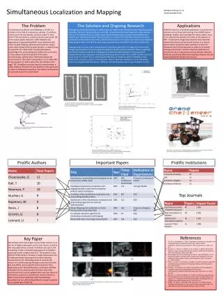
Simultaneous Localization and Mapping and Fully Autonomous Vehicles. Timothy W. Gorecki. The DARPA Grand Challenge. The DARPA Grand Challenge. DARPA Grand Challenge 2004, $1 million No one finished Sandstorm from the Robotics Institute of Carnegie Mellon University drove 7.36 miles.

E N D
Simultaneous Localization and Mapping and Fully Autonomous Vehicles Timothy W. Gorecki
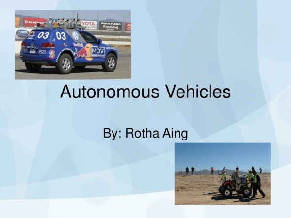
The DARPA Grand Challenge • DARPA Grand Challenge 2004, $1 million • No one finished • Sandstorm from the Robotics Institute of Carnegie Mellon University drove 7.36 miles
The DARPA Grand Challenge • DARPA Grand Challenge 2005, $2 million • 5 Vehicles finished the 132 mile course • Stanley from Stanford University takes first • DARPA announced a third grand challenge scheduled for 3 November, 2007 in an urban environment
Benefits of Autonomous Vehicles • In the US alone, traffic accidents result in the loss of 40,000 lives and 55 billion dollars each year • Drinking & driving and falling asleep behind the wheel • Other applications include agriculture, military, exploration, shipping industries
Localization • Given a map, a compass, and a range finder • Examples : guided missile systems, airplanes, and robots on Mars. • The robot must look about its location
Localization • Sends out a series of beams at small angular intervals • Creates a visible polygon about its location • Compares this polygon to the map • Be able to infer the place (or set of places) in the map where it could be located
Localization: Problems • Areas where there is little to reference from and the robot remaining lost for long periods of time • An environment with many identical locations, such as intersections inside of a major city • Robot in the desert
Mapping • Build a map about its location • Given a means to localize itself, such as a Local positioning system or GPS • Verify its position using the independent positioning system
Mapping • Sends out a series of beams at small angular intervals • Creates a visible polygon about its location • Uses this polygon to create a map • Deals with variations of the map
Mapping: Problem • If the Robot loses its ability to localize itself, the robot becomes blind • Have no way to build an accurate map • Robot in the desert
Simultaneous Localization and Mapping • Given no map • No independent means of localization • Unknown location and environment • Robot must build a map and localize itself off of this map
Simultaneous Localization and Mapping: Problems • The vehicle can not trust its observations to build an accurate map • Without an accurate map, it can not localize itself accurately • Without accurate localization, how can the robot build the map
Simultaneous Localization and Mapping • Vehicle and map estimates are highly correlated • Can not be obtained independently of one another • Two pieces of information are being inferred from the same measurement • How to solve this…
The Kalman Filter • The Kalman Filter recursively computes the estimate of the state of the robot • This Estimation process uses two models • The Process Model: Builds the Map • The Observation Model: Localization
The Process Model • Computes the location of the vehicle • The location of every landmark, assumed to be stationary • Combines these to create a state vector matrix representing the state of map
The Observation Model • Makes observations to verify the location of the landmarks around it • Combines these observations with the map that it built to determine its location
The Estimation Process Cycles through: • Prediction Step • Observation Step • Update Step
The Prediction Step • Estimates the state of the vehicle • Estimates what observations should be • Estimates the state of all landmarks
The Observation Step • Observes or uses sensors to gather information • Compares observations to predictions • Incorporates data received and compared with the probability of it occurring
The Update Step • Updates the Map and the location of the robot based on the probabilities of the last observation being true • Updates the state covariance matrix
The Kalman Filter Theorem 1:The determinant of any sub-matrix of the map covariance matrix decreases monotonically as successive observations are made.
The Kalman Filter Theorem 2: In the limit, the landmark estimates become fully correlated.
The Kalman Filter Theorem 3: In the limit, the lower bound on the covariance matrix associated with any single landmark estimate is determined only by the initial covariance in the vehicle estimate at the time of the first sighting of the first landmark.
The Kalman Filter: Problems • Extremely accurate, but 2N + 3 = M where N in the number of landmarks observed • Kalman Filter is O(M3) • Simple changes reduce this to O(M2) while maintaining accuracy
Beyond The Kalman Filter • Many variations based on the Kalman filter • Extended Kalman Filter: O(2Na2) where Na is the number of landmarks in the local area only • When leaving this local area, the full computational cost is still incurred
Other Difficulties • Negative spaces: pot holes, cliff edges… • Tiny Positive obstacles: wire fences/fence poles… • Dangerous terrain: snow, ice, vegetation, steep slopes, mud… • Deceptive terrain: tall grasses, corn fields…
DARPA Grand Challenge3 November 2007 • Challenge coming up in an urban environment with other mobile vehicles • Obey all traffic laws • 60 mile course through a city • Less than 6 hours to complete this course
Future Benefits • Drinking and Driving/ Falling asleep • Shipping/ postal industry • Harvesting crops • Space exploration • Military applications
References [1] S. F. By John Ward Anderson and J. Finer. Bigger, stronger homemade bombs now to blame for half of u.s. deaths, Wednesday, October 26, 2005. [2] H. Durrant-Whyte. Localization, mapping and the simultaneous localization and mapping (slam) problem, 2002. A presentation held in Sydney, Australia during the SLAM Summer School 2002. Very helpful with defining the localization problem and the mapping problem. Helpful as well with the SLAM problem in general. [3] Guibas, Motwani, and Raghavan. The robot localization problem. In Goldberg, Halperin, Latombe, and Wilson, editors, Algorithmic Foundations of Robotics, The 1994 Workshop on the Algorithmic Foundations of Robotics, A. K. Peters, 1995. [4] E. Nebot. Simultaneous localization and mapping, 2002. A presentation held in Sydney, Australia during the SLAM Summer School 2002. Explains in great detail the SLAM Problem. [5] D. A. Patterson. Robots in the desert: a research parable for our times. Commun. ACM, 48(12):31{33, 2005. Letter describing the Darpa Grand Challenge and the results. [6] Wikipedia. Kalman filter - wikipedia, the free encyclopedia, 2006. Helps to understand the Kalman filter and provided the basic history of its discovery. Online; accessed 5-December-2006. [7] Q. Chen, U. Ozguner, and K. Redmill. Ohio state university at the 2004 darpa grand challenge: Developing a completely autonomous vehicle. IEEE Intelligent Systems, 19(5):8{11, 2004. Ohio States TerraMax with Oshkosh Truck Corporation. 1.) Install a Drive-By-Wire system meeting the safety requirements and then the generators and fuel system to operate the vehicle with all of its equipment. 2.) Provide sensing and information fusion algorithms. 3.) Control the vehicle using the previous two systems at real time and high velocities. [8] G. Dissanayake, S. B. Williams, H. Durrant-Whyte, and T. Bailey. Map management for efficient simultaneous localization and mapping (slam). Auton. Robots, 12(3):267{286, 2002. Not used. [9] A. Kelly, A. Stentz, O. Amidi, M. Bode, D. Bradley, A. Diaz-Calderon, M. Happold, H. Herman, R. Mandelbaum, T. Pilarski, P. Rander, S. Thayer, N. Vallidis, and R. Warner. Toward reliable o road autonomous vehicles operating in challenging environments. Int. J. Rob. Res., 25(5-6):449{483, 2006. The Darpa PerceptOR team from Carnagie Mellon University. [10] M. Montemerlo and S. Thrun. Fastslam 2.0: An improved particle filtering algorithm for simultaneous localization and mapping that provably converges. Shows the improvements to the Fast Slam algorithm implemented by Sebastian Thrun. [11] M. Montemerlo, S. Thrun, D. Koller, and B. Wegbreit. Fastslam: A factored solution to the simultaneous localization and mapping problem, 2002. A good brief description of the Slam Problem and the Fast Slam algorithm. [12] M. S. Montemerlo. Fastslam: a factored solution to the simultaneous localization and mapping problem with unknown data association. PhD thesis, 2003. Chair-William Whittaker and Chair-Sebastian Thrun.