Download
1 / 8
80 likes | 295 Views
MONITORING GLACIAL LAKE OUTBURST FLOODS (GLOFs) IN CHILE. ABSTRACT

E N D
MONITORING GLACIAL LAKE OUTBURST FLOODS (GLOFs) IN CHILE ABSTRACT GLOFs (Glacial Lake Outburst Floods) in southern South America represent a hazard which should become more frequent in the future due to climate warming. Here we propose to study and monitor the potential occurrence of 8 GLOFs in the Andes of Chile (from 27ºS to 53ºS) by means of SPOT high resolution satellite imagery to be acquired in late summer and late winter during a minimum period of 3 years. The main result of the project will be the evaluation of GLOF hazard and the development of an early warming system. The collaboration of Direccion General de Aguas (DGA, Water Directorate) will be engaged and dissemination of results will be carried out in agreement with SPOT IMAGE and DGA.
Modelled atmospheric warming in the Andes between (1990 to 1999) and (2090 to 2099) from Alaska (68°N) to Patagonia (50°S), obtained as the mean of eight different general circulation (IPCC, 2001) using CO2 levels from scenario A2 (Bradley et al., 2006). The Andes mountain elevations are represented with black triangles.
GLOFs IN CHILE With an approximate glacier area of 20,188 km2 (www.glaciologia.cl as of April 11, 2008) Chile concentrates about 75% of the total glacier area in South America (Casassa et al., 2007). About 10 GLOF sites in Chile have been reported from the Copiapó Valley in the north (27ºS) to Patagonia in the south (53ºS). The earliest reports are from the 1950s, with a recent increase of events in Patagonia.
TARGETED GLOF AREAS The following 7 GLOF areas in Chile are proposed to be monitored by means of the acquisition of SPOT high resolution satellite imagery: • Tronquitos Glacier, Copiapó, Atacama desert • Parraguirre Creek, Maipo Valley, Santiago • Soler Lake, Northern Patagonia Icefield • Cachet II Lake, Northern Patagonia Icefield • Témpano Lake, Southern patagonia Icefield • Dickson Lake, Southern Patagonia Icefield • NW Glacier, Gran Campo Nevado, Patagonia
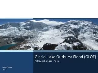
Fig. 2. Extent of Témpano Lake, Southern Patagonia Icefield. The left image is a Landsat TM acquired 14 January 1986. The central image is an ASTER scene of 18 April 2002, where the black lines represent the flight lines performed in 2002 by CECS and NASA onboard a Chilean Navy aircraft. The right image in an ASTER scene acquired April 4, 2007, shortly before the sudden drainage of Lake Témpano.
Former Témpano Lake in May 27, 2007, shorlty after the sudden drainage of the lake. In the middle background are stranded icebergs previously floating on the lake. In the far background the northern front of Témpano Glacier. Phograph acquired by CONAF.
OBJECTIVES • Acquisition of SPOT high resolution imagery ideally two times per year (end of summer and end of winter) for each of the 7 targeted areas • Monitoring of the extent and water level of each of the identified glacial lakes identified within the targeted areas • Monitoring of the areal changes and surface topography changes for the glaciers within each targeted area • Assessment of GLOF hazards based for each targeted area based on the characteristics and evolution of the glacial lakes and glacier extent
PARTICIPANTS MAIN INSTITUTION Centro de Estudios Científicos, Valdivia, Chile Principal Investigator: Gino Casassa, Ph.D., Glaciologist Associate Researcher: Paulina López, Glacio-hydrologist ASSOCIATE INSTITUTIONS Dirección General de Aguas (DGA, Water Directorate), Ministry of Public Works, Chile Patagonia Adventure Expeditions (PAEX) Operators of the Aysén Glacier Trail, performing periodical visits to Cachet II Lake, especially during the summer period.