Download
1 / 16
160 likes | 325 Views
Northern Rockies Precipitation and Temperature Outlook. Winter 2009-2010 Spring – Summer 2010. Precip/Temp Data Oct-Feb. 15. Snowpack 55-75% of normal basin wide Typical El Nino year (80%) Precipitation 50-90% western Montana Portions NW MT and Bitterroot/Missoula valley the lowest

E N D
Northern Rockies Precipitation and Temperature Outlook Winter 2009-2010 Spring – Summer 2010
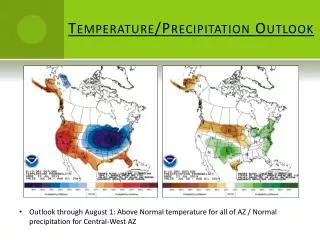
Precip/Temp Data Oct-Feb. 15 • Snowpack • 55-75% of normal basin wide • Typical El Nino year (80%) • Precipitation • 50-90% western Montana • Portions NW MT and Bitterroot/Missoula valley the lowest • 50%-85% North central Idaho • Temperatures • Above normal
2009-2010 El Nino • For Nov/Dec/Jan El Nino Oceanic Nino Index “ONI” was 1.8 • 4thhighestNDJ anomaly on record (97-98, 82-83, 72-3) • Compare current El Nino to previous El Ninos of similar strength • These El Nino years ranged from ONI 1.6 – 2.5 (high mod-strong) • 1957-8 , 1982-3, 1986-87, 91-92, 97-98 • Observed snow and precipitation in western MT and north central ID is around 20% lower than typical Moderate El Ninos El Nino Regions
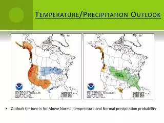
Spring/Summer Outlook • Model consensus, El Nino will continue to weaken, but remain in a weak El Nino State through spring/summer (around 0.5 to 1.0 ONI) • Generally produces wetter/warmer than normal springs (esp. June) • March/April/May – Warmer than normal/Near normal precipitation • Snowpack – expected to remain well below normal if we don’t get significant snows between mid Feb and mid March. • Summers generally wetter and slightly cooler than normal (esp. late June-July) if El Nino continues
Temperature outlook AMJ Precipitation Outlook AMJ
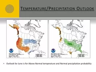
Summary • Moderate El Niño continues across the equatorial Pacific Ocean. • Typical El Nino Winter has occurred (Nov-mid February) • Warmer than normal Temps • Below normal precipitation - 50-75% of normal • Below normal Snowpack - 55-75% of normal • Weak El Niño is forecast through spring/early summer 2010 (ONI .5 - 1.1) • Snowpack – Expected to remain well below normal • Unless significant snow falls between mid Feb – mid March • What is the Potential for the northern Rockies this spring/summer?: • March - Warmer than normal, near normal precipitation • Warmer than normal spring (April – June) • Near normal to wetter spring – wetter especially in June • Near normal to slightly below normal temperatures this summer (Jul – Aug) • Normal to above normal precipitation this summer (Jul – Aug)