Download
1 / 1
10 likes | 138 Views
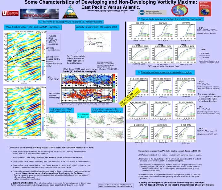
Some Characteristics of Developing and Non-Developing Vorticity Maxima: East Pacific Versus Atlantic. Brandon W. Kerns, Kantave M. Greene, Chuntao Liu, and Edward J. Zipser University of Utah, Department of Meteorology. 2. Two vorticity maxima properties that matter for each region:.

E N D
Some Characteristics of Developing and Non-Developing Vorticity Maxima: East Pacific Versus Atlantic. Brandon W. Kerns, Kantave M. Greene, Chuntao Liu, and Edward J. Zipser University of Utah, Department of Meteorology 2. Two vorticity maxima properties that matter for each region: 1. Two Views of tracking: Wave Features vs. Vorticity Maxima Wave Feature View: TCSP and NAMMA Hovmollers Vorticity Feature View: TS Eugene 2005 DEF: DGP = VORT925-VORT200 (Average Over 2-8 degrees). UNFILTERED FLIGHTS: X = ER-2 + = NOAA P3 * = ER2+P3 = Aerosonde LETTERS: named storms 07/20/0Z UNITS: X 10-6 s-1 UNITS: X 10-6 s-1 UNITS: X 10-6 s-1 07/19/0Z 07/17/0Z 07/18/0Z RATIO RATIO RATIO 07/16/0Z TCSP DEF: 210 K AREA ------------------ 235 K AREA (count all cold cloud area up to 3 degrees from VORT center) But Eugene vorticity Maximum does not Track back across Central America Eugene wave crosses Central America; may be related to Emily! BASED ON LANCZOS FILTER 2.5-10 DAYS AND GAUSSIAN SMOOTHING 3 GRIDPOINTS WIDE. DIMENSIONLESS DIMENSIONLESS DIMENSIONLESS CATL seems to be the winner here. Of all these VORT MAX tracks for May-October 1998-2006… Tracks (925-850 hPa averaged) 3. Properties whose importance depends on region: NON- DEVELOPING DEF: SH = ||V200-V850|| (Vector Average over 0-5 degrees, Then vector difference, then norm). EPAC CATL EATL UNFILTERED DEVELOPING (includes mature stage) The shear statistics Do not appear to depend On the specific radius Or level combination. NAMMA SHEAR IS THIS UNIMPORTANT????? UNITS: m/s UNITS: m/s UNITS: m/s EPAC CATL EATL Track figure courtesy of Greene (2006; MS thesis, U of Utah); Box regions mine. DEF: SH = ||V200-V500|| (Vector Average over 0-5 degrees, Then vector difference, then norm). Look at where the EPAC VORT MAX tracks start. Look at what happens to the VORT MAX tracks leaving Africa. += track start X= track end UNITS: m/s UNITS: m/s UNITS: m/s 1998 1999 1998 1999 DEF: Q_MID = (Q700+Q600 ) / 2 (Gridpoint nearest VORT max). BIG! BIG! 2000 2001 2000 2001 UNITS: g/kg UNITS: g/kg UNITS: g/kg • Conclusions on waves versus vorticity maxima (caveat: based on NCEP/ERA40 Reanalysis “V” wind): • When Hovmoller plots are used, we are tracking the Wave Features. Vorticity maxima must be • tracked by hand or with automated algorithms. • Vorticity maxima come and go every few days while the “parent” wave continues westward. • Wavelike features are much more likely than vorticity maxima to track coherently across the Atlantic. • Wavelike features are more likely to cross Central America, but still it is difficult to find clear-cut cases • of waves crossing Central America using Hovmollers of V component wind. • The vorticity features in the EPAC are probably linked to those in the Atlantic through tropical waves. • However, it is rare to see a wave plowing over Central America from the Caribbean! • There are ways for wave energy to cross Central America without showing up in a Hovmoller of V: • Terrain effects (Zehnder ) • Wave accumulation mechanism • QUESTION TO PONDER: When a tropical cyclone forms, does the wave disappear, or does it move • further westward, possibly inducing cyclogenesis again (possible Emily-Eugene connection)? • Conclusions on properties of Vorticity Maxima (caveat: Based on ERA-40): • DGP discriminated well in all regions, consistent with numerour previous studies. • The fraction of the cloud shield (< 235K) with clouds colder than 210 K, and with • rain rates above 5 mm/hr, seems to matter in all regions. • Vertical shear is most significantly different in the EATL region from 500-200 hPa. • In contrast, SHEAR DOES NOT SEEM IMPORTANT AT ALL IN THE EPAC!!!! • These conclusions do not seem to depend on the specific radius or levels • used to calculate shear. • Mid-level moisture is a significant inhibitor of cyclogenesis in the CATL and EATL. • In the EPAC, mid-level moisture is generally elevated and is not such a good • discriminator. • A theory of cyclogenesis should allow for these regional variations • and not depend Critically on the specific characteristics of any given region. This research funded under the NASA Earth and Space Science Fellowship, Grant # NNX06AF94H.