Download
1 / 14
140 likes | 148 Views
Section 3: Types of Maps. Preview Key Ideas Topographic Maps Topographic Maps and Contour Lines Index Contour, Contour Interval, and Relief Geologic Maps Soil Maps Other Types of Maps Maps in Action. Key Ideas. Explain how elevation and topography are shown on a map.

E N D
Section 3: Types of Maps Preview • Key Ideas • Topographic Maps • Topographic Maps and Contour Lines • Index Contour, Contour Interval, and Relief • Geologic Maps • Soil Maps • Other Types of Maps • Maps in Action
Key Ideas • Explainhow elevation and topography are shown on a map. • Describethree types of information shown in geologic maps. • Identifytwo uses of soil maps.
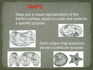
Topographic Maps • One of the most widely used maps is called a topographic map, which shows the surface features of Earth. • topographythe size and shape of the land surface features of a region, including elevations. • elevationthe height of an object above sea level Advantages of Topographic Maps • Topographic maps provide more detailed information about the surface features of Earth than a normal map does.
Topographic Maps, continued Elevation on Topographic Maps • On topographic maps, elevation is shown by using contour lines. • contour linea line that connects points of equal elevation on a map • The difference in elevation between one contour line and the next is called the contour interval. The contour interval is selected based on the relief of the area being mapped. • reliefthe difference between the highest and lowest elevations in a given area • Every fifth contour line is darker than the four lines on each side of it. This index contourmakes reading elevation easier.
Topographic Maps, continued Landforms on Topographic Maps • The spacing and direction of contour lines indicate the shapes of the landforms represented on a topographic map. • Closely spaced contour lines indicate that the slope is steep. • Widely spaced contour lines indicate that the land is relatively level.
Topographic Maps, continued Landforms on Topographic Maps, continued • A contour line that bends to form a V shape indicates a valley. The bend in the V points toward the higher end of the valley; if a stream or river flows through this valley, the V points upstream, or in the direction from which the water flows. • Contour lines that form closed loops indicate a hilltop.
Topographic Maps, continued The diagram below shows how topographic maps represent landforms.
Topographic Maps, continued Reading Check Why do V-shaped contour lines along a river point upstream? Water moves from areas of higher elevation to areas of lower elevation. Because the V shape points toward higher elevation, it points upstream.
Topographic Maps, continued Topographic Map Symbols • Symbols are used to show certain features on topographic maps. • Symbol color indicates the type of feature. Constructed features, such as buildings, are generally shown in black. Major highways are shown in red. Bodies of water are colored blue, and forested areas are colored green. • Contour lines are brown or black.
Geologic Maps • Geologic maps are designed to show the distribution of geologic features, such as the types and age of rocks found an a given area and the locations of faults, folds, and other structures. • Rock Units on Geologic Maps • On geologic maps, geologic units are distinguished by color. Units of similar ages are generally assigned colors in the same color family, such as different shades of blue. • In addition to assigning a color, geologists assign a set of letters to each rock unit. This set of letters symbolizes the age of the rock and the name of the unit or the type of rock.
Geologic Maps, continued Other Structures on Geologic Maps • Other markings on geologic maps are contact lines. A contact lineindicates places at which two geologic units meet, called contacts. • The two main types of contacts are faults, where rocks have moved past each other, and depositional contacts, where one rock layer formed above another. • Geologic maps also indicate the strike and slip of rock beds. Strike indicates the direction in which the beds run, and dip indicates the angle at which the beds tilt.
Soil Maps • Scientists construct soil maps to classify, map, and describe soils, based on surveys of soils in a given area. Soil Surveys • A soil survey consists of three main parts: text, maps, and tables. • The text includes general information about the geology, topography, and climate of the area. • The tables describe the types and volumes of soils in the area. • The maps show the approximate locations and types of the different soils.
Soil Maps, continued Uses of Soil Maps • Soil maps are valuable tools for agriculture and land management. • Soil maps are used by farmers, agricultural engineers, and government agencies. • The information in soil maps and soil surveys helps developers and agencies identify ways to conserve and use soil and plan sites for future development.
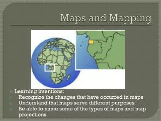
Other Types of Maps • Earth scientists also use maps to show the location and flow of both water and air. • Maps are useful to every branch of Earth science. • Maps may be used to communicate to the public important information on daily weather conditions and emergency situations. • Other types of Earth scientists use maps to study changes in Earth’s surface over time.