Download
1 / 59
590 likes | 773 Views
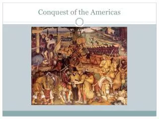
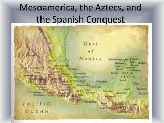
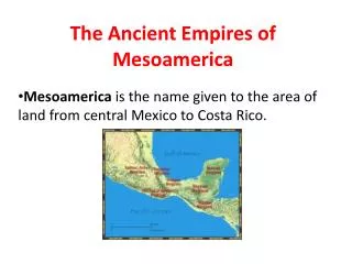
Mesoamerica at the Time of Conquest. Mesoamerican World System: Core Zones Central Mexico Core Zone West Mexico Core Zone Oaxaca Core Zone Maya Core Zone. Central Mexican Core Zone Aztecs Dominate this Core Zone 1200-1521 AD. Aztec City States, Ethnic Groups, and Polities

E N D
Mesoamerican World System: Core Zones • Central Mexico Core Zone • West Mexico Core Zone • Oaxaca Core Zone • Maya Core Zone
Central Mexican Core Zone Aztecs Dominate this Core Zone 1200-1521 AD
Aztec City States, Ethnic Groups, and Polities • “Aztec” refers to Nahuatl-speaking peoples of highland Central Mexico. Aztec-people from Aztlan, “White Land”, a mythical place to the NW. • Mexica, an ethnic group • people from Metzliapán, “Moon Lake,” their name for Lake Texcoco.
In 1428, Aztecs established alliance of three polities: • a)Tenochtitlán (Mexica), • b) Texcoco (Acolhua), and • c) Tlacopan (dissident Tepanec polity). • Mexica, Acolhua, Tepanec are ethnic groups, all of who speak Nahuatl
Tenochtitlán’ssite was where an eagle seated on a cactus eating a snake was spotted. • Population of around 200,000 people. • Great marketplace of Tlatelolco was attended by over 60,000 people daily. • Chinampas produced 7 crops per year and provided over half of the basic food needs of Tenochtitlán.
Main tribute takers were nobility (Pipiltin) whose status was inherited from either parent or both. • Hereditary commoners (macehualtin) were tribute payers. • They lived as free artisans and peasants subject to the demands of public officials, including priests, noble houses, and private landlords. • They were included in any transferal of land.
Huitzilopochtli • was patron of war and human sacrifices • life of sun maintained by feeding it sacrificial blood. • Tlaloc was a rain deity, patron of the agriculturalists.
Quetzalcoatl, the Feathered serpent deity • was patron of the supreme ruler and of priests • represented Topilzin Quetzalcoatl, the legendary priest-ruler of the ancient Toltecs.
West Mexico Core Zone • dominated by single empire, Tarascan empire. • Tzintzuntzan--capital with 35,000 people in Lake Pátzcuaro Basin. • Tarascanempire had 8 city states located within Pátzcuaro basin and conquered an additional 7 city-states adjacent to the basin. • Tarascanempire had no major rivals in the region. • Principal rivals were the Aztecs. • Tarascans were one of the most militarized states in Mesoamerica. • Tarascan (Purépecha) and Nahuatl spoken • Surprisingly, Tarascans had no writing system.
Mixtecs of Southern Mexico (Core) • Western part of state of Oaxaca • Mixtec artisans noted for their brilliant pictographic manuscripts. • Extraordinarily high quality gold, silver, and stonework, polychrome ceramics, and manuscript painting. • Numerous small, competing independent city states. • Elaborate gift exchanges, feasting, and marriage ties between royal families
Maya Core Zone • Present day Guatemala and Yucatan Peninsula. • Southern Highlands (Chiapas and Guatemala) • Central Lake and Tropical Lowlands (Peten and Belize) • Northern Lowlands (Northern Yucatan Peninsula)
Maya Core Zones • Northern Lowlands • Central Lake & Tropical Lowlands • Southern Highlands
Maya core exercised powerful influence over a large area of Mesoamerica, i.e., Central America. • But, there was a relative weakness of ties between its highland and lowland core states. • More than 30 DISTINCT MAYA LANGUAGES • Tzotzil, Jacaltec, Mam, • Ixil, Quiché, Cakchiquel, • and Pokomam
Southern Highlands (Core) • Quiché Maya created an imperial state • Capital of UTATLÁN (also Q’umarkaaj) • 10,000 to 15,000 people • About 30 tribute paying provinces, some that were non-Maya.
Central Lake & Tropical Lowlands (Core) • Itza-Maya • the only core state • capital was TAJ ITZA (also Nohpeten; now the site of Flores) • built on an island within Lake Petén. • Southern Maya groups in Belize and the Itza of the Petén resisted Spaniards for another 155 years (1697).
Northern lowlands of Yucatan (Core) • Most of the peoples had been subject to Mayapánempire • centered on a small city of 11,000 • in NW part of Peninsula. • At Time of Conquest, Northern Lowlands fragmented into smaller city-states
Central Area of Mayapan
Three tiered political hierarchy ruled by lord (Halach Uinic), secondary officials (Batab), and commoners. • Nobles engaged in long distant trading expeditions.
Trade in fish and salt of coast for game and fruit of interior. • Polities exchanged honey, wax, canoes and other wood products, cacao, copal, and cotton textiles • Cacao was used as a currency in marketplace exchange.
Southern highland and Northern Lowland Maya (Core States) • Engaged in LONG DISTANCE trade by land and sea • jade, obsidian, grinding stones, metals, and quetzal feathers of highlands, • textiles, pottery, slaves, honey, and cacao from lowlands.
Mesoamerican SEMI-PERIPHERY • Gulf Coast • South Pacific Coast • Caribbean Coast • exotic religious cults flourished here and served to attract pilgrims.
The Gulf Coast (Semi- Peripheral Zone) • Most Important Semi-peripheral Zone • Ports of trade include COATZACOALCO, XICALANCO, CHAMPOTON (Campeche). • Aztecs, Tzotzil, Quiché, Chontal, and Yucatecan Maya Foreign Merchants
Exchange of manufactured goods (cloth, pottery, gold ornaments, precious-stone jewelry) • For valuable raw materials (feathers, jade, skins, salt, slaves, and Cacao. • Governing class was made up of merchants organized into political councils. • Chontal Maya and Nahuatl spoken