Download
1 / 27
280 likes | 391 Views
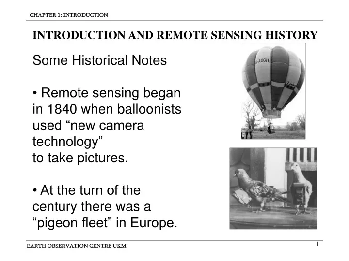
INTRODUCTION AND REMOTE SENSING HISTORY. Some Historical Notes • Remote sensing began in 1840 when balloonists used “new camera technology” to take pictures. • At the turn of the century there was a “pigeon fleet” in Europe. Some Historical Notes.

E N D
INTRODUCTION AND REMOTE SENSING HISTORY Some Historical Notes • Remote sensing beganin 1840 when balloonists used “new camera technology” to take pictures.• At the turn of thecentury there was a“pigeon fleet” in Europe.
Some Historical Notes • Camera systemswere placed on V-2rockets tested atWhite Sands, NMafter WW II.• Sputnik in 1957changed our outlooktoward using outerspace as a place fromwhich to observe theearth.
Milestones in the history of Remote Sensing 1800 : Discovery of infrared by Sir William Herschel 1839: Beginning of practice of photography 1847: Infrared spectrum shown by A. H. L. Fizeau & J.B.L. Foucault to share properties with visible light 1850-1860: Photography from balloons 1873: Theory of electromagnetic energy developed by James Clerk Maxwell 1909: Photography from airplanes 1914-1918: World War 1: aerial reconnaissance 1920-1930: Development & initial application of aerial photography & photogrammetry 1929-1939: Economic depression generates environmental crises that lead to governmental application of aerial photography.
Milestones in the history of Remote Sensing 1930-1940: Development of radars in Germany, US & UK 1839-1945: World War II: application of nonvisible portions of electromagnetic spectrum, training of persons in acquisition and interpretation of airphotos. 1950-1960: Military research and development 1850-1860: Photography from balloons 1956: Colwell research on plant disease detection with infrared photography. 1960-1970: First use of term “remote sensing”, start TIROS weather satellite, Skylab 1972: Launch of Landsat 1 1970-1980: Rapid advances in digital image processing 1980-1990: Landsat 4: new generation of Landsat sensors 1986: SPOT French Earth Observation satellite 1980: Development of hyperspectral sensor
Definition of Remote Sensing "Remote sensing is the science (and to some extent, art) of acquiringinformation about the Earth's surface without actually being in contact with it. This is done by sensing and recording reflected or emitted energy and processing, analyzing, and applying thatinformation" (from Canadian Center for RemoteSensing). What is REMOTE SENSING ?
What is REMOTE SENSING ? • REMOTE SENSING includes all methods and techniques used to gain qualitative and quantitative information about distant objects without coming into direct contact with these objects. • Look-Look, NO Touch
What is REMOTE SENSING ? • Remote Sensing is a much wider field than we will discuss in this lecture series. We will concentrate on that part of RS dealing with EARTH LAND RESOURCES Vision Medical Imaging Sound and Radio Wave Detection
What is REMOTE SENSING ? eg. Camera Sensor System Source of Force Field Resulting RS Data Set eg. Image DATA ACQUISITION Reflection Object(generic)
What is REMOTE SENSING ? DATA PROCESSING Interpretation (secondary) Measurements Data Processing & Mapping (geometric) Presentation of Processing Results Explaining deduced OBJECT INFORMATION RS Data Set eg. Image Object(s)
What is REMOTE SENSING ? Remote Sensing (RS) methods try to answer four basic questions: • HOW MUCH of WHAT is WHERE? • What is the SHAPE and EXTENT of ... ? (Area, Boundaries, Lineaments, ...) • Has it CHANGED? • What is the MIX of Objects?
What is REMOTE SENSING ? HOW MUCH of WHAT is WHERE? WHAT: • Type: eg. water, vegetation, land. • Characteristic: eg. temperature, concentration, state of development. • Properties of object: eg. subtype, species, character and property as well as it’s abstract meaning. => DATA INTERPRETATION
What is REMOTE SENSING ? • HOW MUCH of WHAT is WHERE? • HOW MUCH: determine by simple COUNTING, measuring AREA covered or percentage of total area coverage. • WHERE: Relate locations and area covered to either a standard map or to the actual location on the ‘ground’ where the object occurs. NOTE: WHERE also refers to a moment in time
What is REMOTE SENSING ? • What is the SHAPE and EXTENT of ? (Area, Boundaries, Lineaments, ...) • This extends the ‘WHERE’ to be a completely GEOMETRIC problem. MAP PRODUCTION methods are to be applied to the analysis of RS information. These include: Photogram metric Methods: Identification and Delineation of Boundaries and Lineaments (Roads, Rivers, Fault Lines)
Land use change in Pulau Indah from mangrove forest to industrial area • Has it CHANGED? CHANGE may occur with progress of TIME. Change may be detected through comparison of observed states at different moments in time. => CHANGE DETECTION
What is REMOTE SENSING ? • What is the MIX of Objects? The surface of the Earth is covered by objects like Soil, Water, Grass, Trees, Houses, Roads and so on. These are ‘GENERIC OBJECTS’. We know these well, but we also know objects like Open Forest, Residential and Industrial Estates, etc. Each of these ABSTRACT OBJECTS are made up of a typical collection of Generic Objects.
What is REMOTE SENSING ? • What is the MIX of Objects? One important task for Remote Sensing is to identify GENERIC OBJECTS as well as ABSTRACT OBJECTS within areas of interest The following lessons will be devoted to techniques and methods as well as to the logistic for finding answers to the four basic questions.
What is REMOTE SENSING ? (2) RS requires a SENSOR which can detect changes in the carried Signal. • Apart from our own eyes and ears, technology has provided us with a multitude of sensors operating in the detection of force fields: microphones, geophones, photographic film, video cameras and photo detectors, radio wave receivers, gravimeters and magnetometers.
What is REMOTE SENSING ? (3) RS requires RECORDING, ANALYSIS, INTERPRETATION and REPRESENTATION of the sensed information in a purposeful way. • This is a technique based topic. It is essential for the success or failure of RS in respect of it’s anticipated purpose. • This topic will be dealt with in it’s main aspects (but not completely) in the following lessons.
MANUFACTURE OF AIR BORNE REMOTE SENSING SYSTEM TO EXTRACT THE QUANTITATIVE INFORMATION