Download
1 / 103
1.03k likes | 1.04k Views
United States Global Positioning System (GPS) and Augmentation Systems Update . Ad Hoc Provider’s Forum of the International Committee on GNSS Bangalore, India 4 September 2007. Contents. Services and Provision Policies Michael Shaw System Descriptions GPS Jules McNeff

E N D
United States Global Positioning System (GPS) and Augmentation Systems Update Ad Hoc Provider’s Forum of the International Committee on GNSS Bangalore, India 4 September 2007
Contents Services and Provision Policies Michael Shaw System Descriptions GPS Jules McNeff WAAS/LAAS Carlos Rodriguez Perspective on Compatibility Tom Stanselland Interoperability Spectrum Protection Activities David Turner & Gene Schlechte
U.S. Space-Based Positioning, Navigation, and Timing Policy and Program Update Michael Shaw, Director U.S. National Coordination Office for Space-Based Positioning, Navigation, and Timing
Overview • Service Provision Policies • U.S. Law and Policy • Satellite Navigation Trade and Business Practices
Introduction • Over the past decade, GPS has grown into a global utility providing space-based positioning, navigation and timing (PNT) • Consistent, predictable, dependable policy and performance • Augmentations improve performance even further • Like the Internet, GPS has become a critical component of the global information infrastructure • Scalable applications enabling broad new capabilities • Facilitating innovations in efficiency, safety, environmental, public security, and science
New Applications Are Evolving Every Day • Wireless/mobile applications • Child/pet tracking • Automatic snowplow guidance • Spacecraft control • Power grid management • Open pit mining
GPS: Global Public Service • Global GPS civil service performance commitment continuously met/exceeded since 1993 • SPS Performance Standard (2001) • Access to civilian GPS service is free of direct user charges • As well as USG augmentation services (e.g. NDGPS, WAAS, etc.) • Public domain documentation • Free and equal availability to all users and industry • Equal opportunity to develop user equipment and compete on the world market • Owned and operated by the U.S. Government • Acquired and operated by U.S. Air Force on behalf of USG • Managed at national level as multi-use asset
United States Policy History • 1983: President Reagan offers free civilian access to GPS • 1996: President Clinton issues first U.S. GPS policy • Designates GPS a dual-use system under joint civil/military management • 1997: Congress passes law requiring civil GPS to be provided free of direct user fees • 2000: President Clinton sets Selective Availability to “zero” • 2004: President Bush issues U.S. policy on Space-Based PNT
U.S. Law – 10 U.S. Code §2281 The Secretary of Defense: • Shall provide for the sustainment of GPS, and the operation of basic GPS services, that are beneficial for the national security interests of the U.S. • Shall provide for the sustainment and operation of the GPS Standard Positioning Service for peaceful civil, commercial, and scientific uses • Continuous worldwide basis free of direct user fees Policy and Law establish dual-service operation and sustainment of GPS
U.S. Policy Promotes Commercial Markets/Applications Growth • Provide civil GPS and augmentations free of direct user fees on a continuous, worldwide basis • Provide open, free access to information needed to use civil GPS and augmentations • Improve performance of GPS and augmentations • Seek to ensure that international space-based PNT systems are interoperable with civil GPS and augmentations or, at a minimum, are compatible Policy stability and transparency improve industry confidence and investment
2004 U.S. Space-Based PNT Policy Updated policy retains 1996 principles • Recognizes the changing international scene • Other nations implementing space-based systems that provide PNT services • National Space-Based PNT Executive Committee • Chaired by Deputy Secretaries of Defense and Transportation • Membership includes: State, Commerce, Homeland Security, JCS and NASA • Established National Coordination Office (NCO) a with staff from each member agency
Defense Transportation NATIONALSPACE-BASED PNT EXECUTIVE COMMITTEE Co-Chairs: Defense, Transportation State ADVISORYBOARD Sponsor: NASA Commerce Homeland Security Joint Chiefs of Staff COORDINATIONOFFICE Host: Commerce NASA U.S. Organizational Structure WHITE HOUSE
National Coordination Office • Facilitates information sharing, coordination, and issue resolution regarding space-based PNT across all Departments • Evaluates plans to modernize U.S. space-based PNT infrastructure • Conducts or oversees space-based PNT studies, analyses, and projects that have broad U.S. Government participation • Represents the Executive Committee in discussion with federal, state, local, and foreign governments
National Space-Based PNT Advisory Board • Conducts assessments, makes recommendations to accomplish national policy goals and objectives • Twenty-four members; six international members • First meeting held March 2007 • Next meeting in October 2007
Provide civil GPS and augmentations free of direct user fees on a continuous, worldwide basis Seek to ensure international systems are interoperable, or at a minimum, are compatible, with civil GPS and augmentations Improve performance of civil GPS and augmentations to meet or exceed that of international systems Provide open, free access to information needed to develop equipment Encourage international development of PNT systems based on GPS U.S. International Cooperation Outlined in 2004 U.S. National Policy on Space-Based Positioning, Navigation, and Timing (PNT)
Bilateral GPS Cooperation • U.S.-Japan: Policy and technical consultations on GPS cooperation since 1996 • QZSS augmentation to be compatible, interoperable with GPS • U.S.-EU GPS-Galileo Cooperation Agreement since 2004 • July 2007 accord on improved civil signal (MBOC) • U.S.-India: Policy and technical consultations on GPS cooperation since 2005 • Research into ionospheric distortion/solutions • Joint Statement on GNSS Cooperation, February 2007 • U.S.-Russia negotiating GPS-GLONASS Cooperation Agreement since 2005 • Discussing greater interoperability of civil GPS-GLONASS signals • U.S.-Australia: Joint Delegation Statement on Civil GPS cooperation signed April 2007 • Developing enhanced mechanisms for notification of GPS satellite operational changes
Summary • The U.S. supports free access to civilian GNSS signals with public domain documentation necessary to develop user equipment • GPS is a critical component of the global information infrastructure • Compatible with other satellite navigation systems and interoperable at the user level • Guided at a national level as multi-use asset • Acquired and operated by Air Force on behalf of the USG • U.S. Government policy promotes open competition and market growth for commercial GNSS GPS is a Global Public Service providing consistent, predictable, dependable performance
The Global Positioning System (GPS) Jules McNeff representing Office of the Assistant Secretary of Defense Networks and Information Integration U.S. Department of Defense
Overview • Global Positioning System Description • System Improvements & Modernization • GPS Constellation Status • Next Steps for Space and Control Segments • System Performance
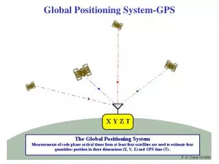
The Global Positioning System • Baseline 24 satellite constellation in medium earth orbit • Global coverage, 24 hours a day, all weather conditions • Satellites broadcast precise time and orbit information on L-band radio frequencies • Two types of signals: • Standard (free of direct user fees) • Precise (U.S. and Allied military) • Three segments: • Space • Ground control • User equipment
Overview • Global Positioning System Description • System Improvements & Modernization • GPS Constellation Status • Next Steps for Space and Control Segments • System Performance
Current Constellation 30 Operational Satellites (Baseline Constellation: 24) • 15 Block IIA satellites operational • 12 Block IIR satellites operational • 5 remaining Block IIR satellites are modernized • 3 Block IIR-M satellites operational • Transmitting new civil signal (L2C) • U.S. Government continuously assessing constellation health to determine launch need • New IIR-M satellites launched • Sep 05, Sep 06, Nov 06 • Next launch: Oct 07 • Global GPS civil service performance commitment met continuously since Dec 2003
Overview • Global Positioning System Description • System Improvements & Modernization • GPS Constellation Status • Next Steps for Space and Control Segments • System Performance
Modernized GPS – Civil Signals • Second civil signal (“L2C”) • Designed to meet commercial needs • Higher accuracy through ionospheric correction • Higher effective power and improved data structure reduce interference, speed up signal acquisition, enable miniaturization of receivers, may enable indoor use • Began with GPS Block IIR-M in Sep 2005; 24 satellites: ~2014 • Third civil signal (“L5”) • Designed to meet demanding requirements for transportation safety (safety-of-life) • Uses highly protected Aeronautical Radio Navigation Service (ARNS) band • Begins with GPS Block IIF • First launch: ~2008; 24 satellites: ~2016 • Fourth civil signal (“L1C”) • Designed with international partners to enable GNSS interoperability • Begins with GPS Block III • First launch: ~2013; 24 satellites: ~2021
P(Y) C/A L2C M L5 L1C L5 L1 L2 GPS Modernization – Spectrum Block IIA, 1990 previous as of Dec 2005 Block IIR-M, 2005 planned Block IIF, 2008 Block III, 2013 (artist’s concept) ARNS BandRNSS BandARNS Band
GPS Evolutionary “System-of-Systems” Programs Space Segment • Modernized(Block IIR-M) • 2nd civil signal (L2C) • M-Code signals (L1M, L2M) • Anti-jam flex power • Modernized(Block IIF) • 3rd civil signal (L5) GPS III(Block III) • Increased accuracy • Increased A/J power • Signal integrity • Search and Rescue • L1C civil signal common w/Galileo, QZSS, & possibly GLONASS • Legacy(Block IIA/IIR) • Std Service (≤ 6 meters RMS SIS SPS URE) • Single frequency (L1) • Coarse acquisition (C/A) code navigation • Precise Service (≤ 2.6 m 95% URE PPS at Zero AOD) • Y-Code (L1Y & L2Y) • Y-Code navigation Ground Segment Legacy • TT&C • L1 & L2 monitoring Upgraded(AEP) • IIR-M IIF TT&C • WAGE, AII, LADO • NMCS/AMCS Modernized(OCX V1) • New Architecture • Signal Monitoring GPS III(OCX V2) • GPS III TT&C • Real-Time C2
GPS OCS Modernization Status • Transitioning to new ground segment - September 2007 • OCS Modernization impacts every element of OCS architecture • Architecture Evolution Plan (AEP) migrates OCS from mainframe to distributed architecture -- makes OCS easier to operate/maintain • Two new control stations: • New Module at Schriever AFB • New Alternate MCS (AMCS) at VAFB • AEP provides flexibility to incorporate future requirements • Command and Control for IIF (1st launch scheduled for 2008)
Modernizing the operational control segment (OCS) • Each SV tracked by three or more monitor stations over 99% of time
Overview • Global Positioning System Description • System Improvements & Modernization • GPS Constellation Status • Next Steps for Space and Control Segments • System Performance
Constellation PerformanceJanuary 1-December 31, 2004 Specification values from the Standard Positioning Service Performance Standard, October, 2001 • PDOP (Geometry) Availability • Specification - PDOP of 6 or Less, 98% of the time • Actual - 99.98798% • Horizontal Service Availability • Specification - 95% Threshold of 36 meters, 99% of the Time • Actual – 2.74 meters • Vertical Service Availability • Specification - 95% Threshold of 77 meters, 99% of the Time or Better • Actual – 3.89 meters • User Range Error • Specification - 6 meters or Less, Constellation Average • Actual – see next chart System accuracy and availability far exceed current specifications
Summary • GPS has been operational and has met its civil service performance commitment continuously since Dec 2003 • Performance continues to exceed standards • GPS modernization is underway • New civil signals being launched • Modernized control capabilities being implemented
Wide Area Augmentation System (WAAS) and Local Area Augmentation System (LAAS) Update Carlos Rodriguez, FAA Dr. Navin G. Mathur, AMTI
Agenda • WAAS Architecture • WAAS Ground and Space Segment Update • Phase II – Full LPV Performance (FLP) • Phase III – Full LPV-200 Performance (FLP) • Phase IV – Dual frequency Operations • WAAS User Segment Update • SBAS Interoperability Efforts • LAAS Architecture • GBAS Activity Update
WAAS Architecture 38 Reference Stations 3 Master Stations 4 Signal Generator System/ Ground Earth Stations 2 Geostationary Satellite Links 2 Operational Control Centers
Intelsat 133°W Telesat 107°W GEO Satellite Improvements • IOC WAAS (Commissioned system) utilized two Inmarsat satellites • Provided single satellite coverage over the majority of the U.S. • Inmarsat satellites removed from operational WAAS July 2007 • Two replacement satellites launched in 2005 • Intelsat (Galaxy XV) • Operational November 2006 (Datalink Only) • Ranging scheduled operational mid 2008 • Telesat Canada (Anik F1R) • Operational July 2007, for corrections & ranging
WAAS Ground andSpace segment Update • WAAS Acquisition Phases • WAAS Commissioned – IOC – Phase I 2003 • Full LPV Performance – Phase II 2003-2008 • Full LPV-200 Performance – Phase III 2009-2013 • Dual Frequency Operations – Phase IV 2014-2028 • Procedure Development ~300/year 2004-2028
WAAS Program Status – Phase II Full LPV Performance (FLP) • Localizer Performance with Vertical Guidance to 250’ • Provide Full LPV service with a limited LPV-200 approach service availability and coverage within the CONUS • LPV approach service extended to Alaska and portions of Canada and Mexico • Highlights include: • Two new leased GEO satellites that provide the WAAS broadcast SIS, • An additional master station, • Enhancements to the broadcast corrections, and • Additional wide area reference stations (5 Mexico and 4 Canada)
GPS Performancewith WAAS and LAAS WAAS Performance evaluated based on a total of 1,761 million samples (or 20,389 user days) LAAS Performance is based on the 104 LAAS approaches at Memphis Airport
WAAS Program Status – Phase III Full LPV-200 Performance • Provides for a robust, reliable, and sustainable LPV-200 capability • Support transition of WAAS maintenance and development capabilities to the FAA • Planned WAAS Algorithm Updates for Phase III • Acquisition of additional GEO satellite • WIPP Participation for continual GIVE Algorithm Tuning (especially during the approaching Solar max) • A contract award for the WAAS Phase III Transition efforts (WAAS Follow-on) is anticipated in Summer 2008
WAAS Program Status – Phase IV • Dual Frequency Operations • Maintain a robust, reliable, and sustainable LPV-200 capability • Support Single frequency WAAS users through end of Phase IV (2028) • Support User Equipage of dual frequency (L1/L5) avionics • GPS Evolutionary Architecture Study (GEAS) Group formed – Fall 2006 • Goal of GEAS is to identify, evaluate, and recommend GNSS-based architecture (s) for robust LPV-200 service worldwide (circa 2025-30)
WAAS Avionics Status • Total WAAS equipped users ~15,000 • Approximately 40% of est. 140,000 GA aircraft are equipped with Garmin receivers • GNS-400/500 series: • 75,000 non-WAAS capable receivers sold • 18,000 owners have registered for WAAS upgrade • Plan to upgrade 300 units a month, currently far exceeding that rate • Over 6,800 units upgraded to date • New production receivers are WAAS capable • 3,800 units shipped • Rockwell-Collins: Challenger aircraft approval – August 2007 • CMC: FAA contract to integrate CMC WAAS sensor into Honeywell Primus 2000 FMS in FAATC Global 5000 aircraft, expected in 2008 • Universal Avionics: Developing WAAS-enabled capability in dual thread UNS-1 FMS TSO in Summer ’07
WAAS Procedure Production Type of ApproachProcedures To Date Total GNSS Approaches 4225 LNAV/VNAV 1121 LPV 925
SBAS InteroperabilityWorking Group (IWG) • The FAA supports the mission of the IWG –Which is “To perform adequate coordination and cooperation between SBAS Project Offices aiming at ensuring compatibility and interoperability of their respective SBAS Systems over lifetime for the benefit of the SBAS user communities” • The 5 primary objectives of the IWG are: • Objective 1: Harmonize SBAS modernization plans • Objective 2: Forum for discussion on SBAS Technical issues • Objective 3: Harmonize technical improvements from Operation and users feedback • Objective 4: R&D cooperation on key SBAS technologies • Objective 5: Support joint SBAS promotion