Download
1 / 4
40 likes | 135 Views
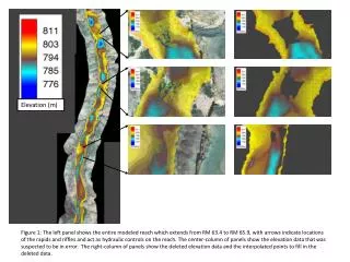
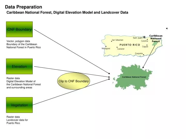
Data Preparation. Caribbean National Forest, Digital Elevation Model and Landcover Data. CNF Boundary. Vector, polygon data Boundary of the Caribbean National Forest in Puerto Rico. Elevation. Clip to CNF Boundary. Raster data Digital Elevation Model of the Caribbean National Forest

E N D
Data Preparation Caribbean National Forest, Digital Elevation Model and Landcover Data CNF Boundary Vector, polygon data Boundary of the Caribbean National Forest in Puerto Rico Elevation Clip to CNF Boundary Raster data Digital Elevation Model of the Caribbean National Forest and surrounding areas Vegetation Raster data Landcover data for Puerto Rico
Data Analysis Good Habitat E unicolor vegetation Lower montane wet evergreen forests tall palm, elfin palm and cloud forest vegetation classification of CNF E. unicolor potential_habitat elevation E. Unicolor habitat areas with both elevation of 670-1005m and cloud forest vegetation within CNF Elevation of CNF from 670-1005m Buffer 10m roads roads_buffer unicolor_habitat E. unicolor potential_habitat Areas with both elevation of 670-1005m and cloud forest vegetation and at least 10m away from any roads within CNF
Data Analysis Good Habitat E gryllus vegetation Lower montane wet evergreen forests tall palm, elfin palm and cloud forest vegetation classification of CNF E. gryllus potential_habitat elevation E. gryllus habitat areas with both elevation greater than 700m and cloud forest vegetation within CNF Elevation of CNF greater than 700m Buffer 10m roads roads_buffer gryllus_habitat E. gryllus potential_habitat Areas with both elevation greater than 700m and cloud forest vegetation and at least 10m away from any roads within CNF
Data Analysis Good Habitat E karlschmidti vegetation E. karlschmidti potential_habitat Lowland moist seasonal evergreen forest, submontane wet evergreen forest, and submontane and lower montane wet evergreen forest/shrub and active abandoned shade coffee vegetation classification of CNF E karlschmidti habitat areas with both elevation of 45-630m and suitable vegetation within CNF elevation Elevation of CNF from 45-630m streams Buffer 20m stream_buffer karlschmidti_habitat E. karlschmidti potential_habitat Areas within 20m of streams with both an elevation of 45-630m and suitable vegetation for E_karlschmidti within CNF