Download
1 / 29
290 likes | 484 Views
SeaDataNet NetCDF for Point Data. Roy Lowry British Oceanographic Data Centre. Presentation Overview. What are N etCDF and CF? SeaDataNet profiling of CF1.6 Interoperability Parameter Naming Mapping data types onto SeaDataNet NetCDF Further profiling of SeaDataNet NetCDF.

E N D
SeaDataNet NetCDF for Point Data Roy Lowry British Oceanographic Data Centre
Presentation Overview • What are NetCDF and CF? • SeaDataNet profiling of CF1.6 • Interoperability • Parameter Naming • Mapping data types onto SeaDataNet NetCDF • Further profiling of SeaDataNet NetCDF
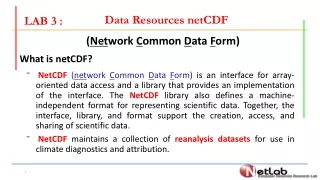
NetCDF • Network Common Data Form (NetCDF) is an interface for array-oriented data access and a library that provides an implementation of the interface. • What does this mean? • NetCDF is a data model rather than a data format • Data in NetCDF are accessed by API or tools calling that API
NetCDF • Practical points • Binary data format • Details of underlying format depends upon API library version (NetCDF3, NetCDF4, HDF5) • API initially developed for C and Fortran • Matlab and Java now available • NetCDF developed and supported by UniData in Boulder Colorado
CF Conventions • Climate and Forecast Metadata Conventions (CF) is a ‘profile’ of the NetCDF data model designed to enhance data interoperability • Developed by the global atmosphere-ocean coupled modelling community to provide interoperability for IPCC intercomparisons • Governed on an open community model based around e-mail list server and Trac moderated by a committee with voting rights (should they ever be needed) • Adopted by SeaDataNet
CF Conventions • A ‘profile’ reduces the number of degrees of freedom in a data model by: • Modelling the model • CF concepts of co-ordinate, geophysical and ancillary variables • Global and parameter attribute naming and status (mandatory, conditional, recommended) • Establishing rules (e.g. Geophysical variable must be linked to at least one co-ordinate variable) • Standardising semantics through controlled vocabularies • Standard Names • Cell Methods
CF Conventions • CF developed by GCM modelling community • Versions 1.0 to 1.5 only supported gridded data • Strong atmospheric science bias in the design principles and the semantic resources like Standard Names • CF 1.6 developed by John Carron of UniData to support ‘point data’ • CF1.6 based on the concept of ‘feature type’ defined by co-ordinate variable patterns
SeaDataNet NetCDF • Two types of NetCDF used in SeaDataNet • CF 1.5 profile for gridded data (L24 = CF) - largely out of scope for this presentation • CF1.5 plus SeaDataNet P01/P06 parameter attributes and metadata linkage arrays (SDN_CRUISE, SDN_STATION, SDN_LOCAL_CDI_ID and SDN_EDMO_CODE) from CFPOINT • CF 1.6 profile for point data (L24 = CFPOINT) • CFPOINT profile modifies CF 1.6 as follows • Point feature type excluded • Additional conventions • Additional mandatory attributes and metadata arrays • Additional optional attributes and metadata arrays
SeaDataNet NetCDF • Additional conventions • Representation of time is UT expressed as Chronological Julian Day • Representation of position is actual or assumed EPSG4326 (WGS-84 2D geographic co-ordinates) • Mandatory depth/height for time series • Names of x, y and z co-ordinate variables are fixed • ‘Position’ SeaDataNet QC flag ancillary variable for latitude+longitude • SeaDataNet QC flag ancillary variables for all other co-ordinate and geophysical variables named 'variable_SEADATANET_QC'
SeaDataNet NetCDF • Mandatory extensions • Parameter attributes • sdn_parameter_urn (P01 URN) • sdn_parameter_name (P01 entryTerm) • sdn_uom_urn (P06 URN) • sdn_uom_name (P06 entryTerm)
SeaDataNet NetCDF • Mandatory extensions • Metadata arrays • crs (EPSG4326 declaration) • SDN_CRUISE (grouping label e.g. cruise for profiles) • SDN_STATION (series label e.g. profile name) • SDN_LOCAL_CDI_ID (local CDI identifier) • SDN_EDMO_CODE (namespace for local CDI)
SeaDataNet NetCDF • Optional extensions • Parameter attributes • sdn_instrument_urn (L22 URN) • sdn_instrument_name (L22 entryTerm) • Metadata arrays • SDN_BOT_DEPTH (water depth: mandatory for profiles) • SDN_REFERENCES (single XHTML URI - backwards compatibility) • SDN_XLINK (multiple XML/XHTML document linkages following XLINK)
Interoperability • Design Principle • Interoperability through duplication • Examples • Multilingual signs • CF Standard Names AND P01 URNs in SeaDataNet NetCDF
Interoperability • Flagging conventions are a notorious area of non-interoperability • SeaDataNet • OceanSites • ODV • ARGO • QARTOD • IODE • 16 conventions documented in L27 vocabulary
Interoperability • One solution is to attach multiple CF ancillary variable arrays to each co-ordinate or geophysical variable • Shifts the load from the data consumer to the data provider • If mapping is involved the data provider is more likely to get it right! • SeaDataNet NetCDF specification is the LOWEST COMMON DENOMINATOR • Embellishment encouraged is it make the data more interoperable
Parameter Naming • CF specifies two parameter attributes for naming each parameter • Standard Name (controlled vocabulary) • Long Name (free text) • Standard Names have issues • Coverage atmospheric rather than oceanographic • Content governance is out of SeaDataNet control and broken
Parameter Naming • SeaDataNet solution • Make the Standard Name optional, but strongly recommend its use for the sake of interoperability • Therefore Long Name is mandatory (CF rules) • Add SeaDataNet namespace parameter attributes • sdn_parameter_urn (P01 URN) • sdn_parameter_name (P01 entryTerm) • sdn_uom_urn (P06 URN) • sdn_uom_name (P06 entryTerm)
Parameter Naming • SeaDataNet vocabulary URNs • Syntax is 'SDN:' || Library || '::' || ConceptID • Example - SDN:P01::TEMPPR01 • SeaDataNet names • Concept entryTerm • Example - Temperature of the water body • Likewise for units (P06 vocabulary) and instruments (L22 vocabulary)
Mapping Data Types • There are five types of SeaDataNet NetCDF file • Correspond to the CF 1.6 Feature Types • profile • timeSeries • trajectory • timeSeriesProfile • trajectoryProfile • Data need to be mapped onto one of these • INSTANCE dimension for CF1.6 compatibility • Allows multiple series per file • Set to 1 for normal SeaDataNet objects
Mapping Data Types • profile • Measurements in one place, one time, many depths • Examples are CTD, XBT, bottle data, radiosondes, etc. • SeaDataNet considers z co-ordinate to always be spatial for profiles (depth, pressure, height)
Mapping Data Types • timeSeries • Measurements in one place, one depth, but at many different times • Examples are recording current meter record, seafloor pressure gauge, moored temperature logger • SeaDataNet requires a height/depth co-ordinate variable with one value per series (nominal covering all time steps) • Also possible to include pressure or depth as a geophysical variable (value for each time step), but this is NOT a co-ordinate variable
Mapping Data Types • trajectory • Like timeSeries but measurements in a different place for each time step • Can be 2D or 3D. Either can have a depth/height/pressure co-ordinate variable with one value per time step • Only one z co-ordinate value per time step • Examples are thermosalinograph or AUV-mounted CTD data
Mapping Data Types • timeSeriesProfile and trajectoryProfile • Conceptually a little more difficult • Think of timeSeries or trajectory as referring to the platform • Tagged onto these are • Profile z co-ordinates for each time step • Data values for each profile z co-ordinate value at each time step • Profile z co-ordinates can be spatial (e.g. ADCP bin depth) but non-spatial parameters (e.g. wavelength) are also permitted
Mapping Data Types • timeSeriesProfile • Platform is in the same place for every time step • One depth value per series required • Depth array (INSTANCE, MAXT) with one value per time step permitted as a geophysical variable • Example is moored ADCP data • PROFZ - profile Z co-ordinate array (INSTANCE, MAXT, MAXZ) contains bin depths • Geophysical variables • For each bin - e.g. current velocity (INSTANCE, MAXT, MAXZ) • One per time step - e.g. instrument water temperature sensor (INSTANCE,MAXT) • Also fits thermistor chains, particle sizer time series and spectral radiometer time series
Mapping Data Types • trajectoryProfile • Platform in a different place for each time step • Platform latitude, longitude and depth (INSTANCE, MAXT) arrays (so will cope with AUV ADCP data) • Example is vessel-mounted ADCP data • PROFZ - profile Z co-ordinate array (INSTANCE, MAXT, MAXZ) contains bin depths • Geophysical variables • For each bin - e.g. current velocity (INSTANCE, MAXT, MAXZ) • One per time step - e.g. bottom-tracking data (INSTANCE,MAXT) • Also fits towed thermistor chains, AUV-mounted optical plankton counter or particlesizer
Mapping Data Types • Introducing a little bit of controversy • The ODV extension for biological data introduces the idea of species as a dimension • Therefore PROFZ could be a LSID or numeric equivalent such AphiaID • A zoobenthos biomass survey could therefore be mapped onto trajectoryProfile SeaDataNet NetCDF • Biological data in a binary format!!! • Would need an Excel import tool for it to be accepted
SeaDataNet NetCDF Profiling • SeaDataNet format specification is a lowest common denominator • Further restrictions and extensions may be specified to cover requirements for specific types of data • For example: • Making geophysical variables mandatory • Platform velocity required for relative wind direction data • Mandatory data-type specific metadata • SDN_XLINK in XBT data to the MO C3 vocabulary to provide access to the drop rate equation • SDN_XLINK in cruise data to CSR document providing access to information like PSO name
SeaDataNet NetCDF Profiling • Nemo software already profiles the basic SeaDataNet specification through the inclusion of additional global attributes • Should a manual documenting SeaDataNet format for every type of oceanographic data (CTD, moored ADCP, VMADCP, etc.) be produced? • Requires extensive domain knowledge • Stretches capabilities of technical expert groups like SeaDataNet TTT • Would have to be produced by user communities
SeaDataNet NetCDF Profiling • Documenting specific data types • A better approach might be: • Identify community best practice • Capture it • Build a library of example data files That's All Folks!!