Download
1 / 1
20 likes | 168 Views
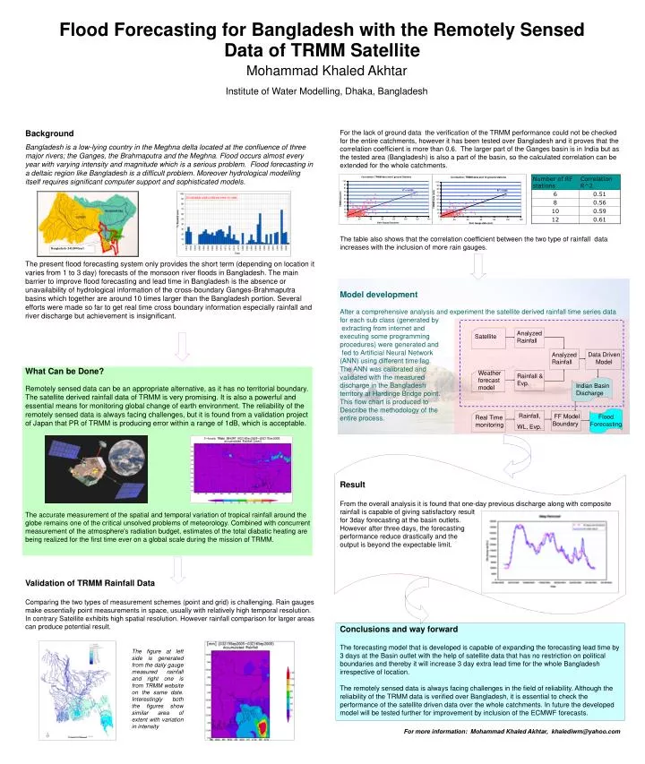
Analyzed Rainfall. Satellite. Data Driven Model. Analyzed Rainfall. Bangladesh (145,000 km 2 ). Weather forecast model. Rainfall & Evp. Indian Basin Discharge. Rainfall, WL, Evp. FF Model Boundary. Flood Forecasting. Real Time monitoring.

E N D
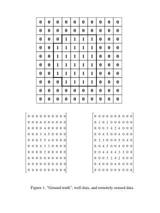
Analyzed Rainfall Satellite Data Driven Model Analyzed Rainfall Bangladesh (145,000 km2) Weather forecast model Rainfall & Evp. Indian Basin Discharge Rainfall, WL, Evp. FF Model Boundary Flood Forecasting Real Time monitoring Mohammad Khaled AkhtarInstitute of Water Modelling, Dhaka, Bangladesh Flood Forecasting for Bangladesh with the Remotely Sensed Data of TRMM Satellite • Background • Bangladesh is a low-lying country in the Meghna delta located at the confluence of three major rivers; the Ganges, the Brahmaputra and the Meghna. Flood occurs almost every year with varying intensity and magnitude which is a serious problem. Flood forecasting in a deltaic region like Bangladesh is a difficult problem. Moreover hydrological modelling itself requires significant computer support and sophisticated models. • The present flood forecasting system only provides the short term (depending on location it varies from 1 to 3 day) forecasts of the monsoon river floods in Bangladesh. The main barrier to improve flood forecasting and lead time in Bangladesh is the absence or unavailability of hydrological information of the cross-boundary Ganges-Brahmaputra basins which together are around 10 times larger than the Bangladesh portion. Several efforts were made so far to get real time cross boundary information especially rainfall and river discharge but achievement is insignificant. • What Can be Done? • Remotely sensed data can be an appropriate alternative, as it has no territorial boundary. The satellite derived rainfall data of TRMM is very promising. It is also a powerful and essential means for monitoring global change of earth environment. The reliability of the remotely sensed data is always facing challenges, but it is found from a validation project of Japan that PR of TRMM is producing error within a range of 1dB, which is acceptable. • The accurate measurement of the spatial and temporal variation of tropical rainfall around the globe remains one of the critical unsolved problems of meteorology. Combined with concurrent measurement of the atmosphere's radiation budget, estimates of the total diabatic heating are being realized for the first time ever on a global scale during the mission of TRMM. • Validation of TRMM Rainfall Data • Comparing the two types of measurement schemes (point and grid) is challenging. Rain gauges make essentially point measurements in space, usually with relatively high temporal resolution. In contrary Satellite exhibits high spatial resolution. However rainfall comparison for larger areas can produce potential result. For the lack of ground data the verification of the TRMM performance could not be checked for the entire catchments, however it has been tested over Bangladesh and it proves that the correlation coefficient is more than 0.6. The larger part of the Ganges basin is in India but as the tested area (Bangladesh) is also a part of the basin, so the calculated correlation can be extended for the whole catchments. The table also shows that the correlation coefficient between the two type of rainfall data increases with the inclusion of more rain gauges. Model development After a comprehensive analysis and experiment the satellite derived rainfall time series data for each sub class (generated by extracting from internet and executing some programming procedures) were generated and fed to Artificial Neural Network (ANN) using different time lag. The ANN was calibrated and validated with the measured discharge in the Bangladesh territory at Hardinge Bridge point. This flow chart is produced to Describe the methodology of the entire process. Result From the overall analysis it is found that one-day previous discharge along with composite rainfall is capable of giving satisfactory result for 3day forecasting at the basin outlets. However after three days, the forecasting performance reduce drastically and the output is beyond the expectable limit. Conclusions and way forward The forecasting model that is developed is capable of expanding the forecasting lead time by 3 days at the Basin outlet with the help of satellite data that has no restriction on political boundaries and thereby it will increase 3 day extra lead time for the whole Bangladesh irrespective of location. The remotely sensed data is always facing challenges in the field of reliability. Although the reliability of the TRMM data is verified over Bangladesh, it is essential to check the performance of the satellite driven data over the whole catchments. In future the developed model will be tested further for improvement by inclusion of the ECMWF forecasts. For more information: Mohammad Khaled Akhtar, khalediwm@yahoo.com The figure at left side is generated from the daily gauge measured rainfall and right one is from TRMM website on the same date. Interestingly both the figures show similar area of extent with variation in intensity