Download
1 / 15
150 likes | 230 Views
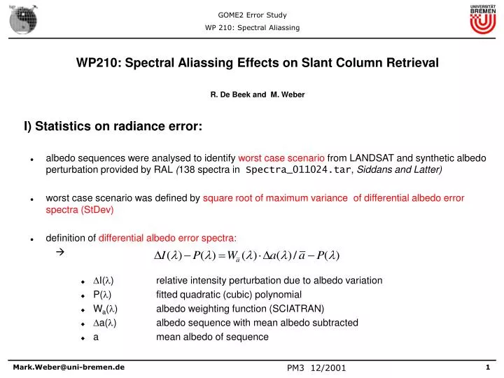
WP210: Spectral Aliassing Effects on Slant Column Retrieval R. De Beek and M. Weber I) Statistics on radiance error:

E N D
WP210: Spectral Aliassing Effects on Slant Column Retrieval • R. De Beek and M. Weber • I) Statistics on radiance error: • albedo sequences were analysed to identify worst case scenario from LANDSAT and synthetic albedo perturbation provided by RAL (138 spectra in Spectra_011024.tar, Siddans and Latter) • worst case scenario was defined by square root ofmaximum variance of differential albedo error spectra (StDev) • definition of differential albedo error spectra: • I() relative intensity perturbation due to albedo variation • P() fitted quadratic (cubic) polynomial • Wa() albedo weighting function (SCIATRAN) • a() albedo sequence with mean albedo subtracted • a mean albedo of sequence
albedo weighting function calculated for a 55N April scenario (SZA=49.5°, RAZ=57°, LOS=0°, albedo=0.5) • categories of albedo sequences: • 1m_box_80 40X80 km2 GOME pixel (IT=0.1875s), no IFOV convolution • 1m_box_40 40X40 km2 GOME pixel (reduced swath width), no IFOV convolution • gome2_box_80 40X80 km2 GOME pixel, IFOV GOME2 boxcar convolution • gome2_box_40 40X40 km2 GOME pixel, IFOV GOME2 boxcar convolution • gome2_80 40X80 km2 GOME pixel, IFOV GOME2 slit function convolution • gome2_40 40X40 km2 GOME pixel, IFOV GOME2 slit function convolution • error perturbation calculated for all possible albedo sequences in each scan contained in the 138 selected images (Landsat, synthetic images).
Worst Case Statistics: Ozone (O3) Landsat Images (black ROT=46ms, blue ROT=6ms) Position Scan StDev mean albedo sequence file albedo 3585 1 3.87e-04 0.124 img6/l71075090_09020000413_10_1m_box_40 3575 1 3.57e-04 0.127 img6/l71075090_09020000413_10_gome2_box_40 3578 1 3.57e-04 0.127 img6/l71075090_09020000413_10_gome2_40 3318 1 2.55e-04 0.135 img6/l71075090_09020000413_10_1m_box_80 3344 1 2.33e-04 0.132 img6/l71075090_09020000413_10_gome2_box_80 3345 1 2.33e-04 0.132 img6/l71075090_09020000413_10_gome2_80 3360 1 0.29e-04 0.135 img6/l71075090_09020000413_10_gome2_80 Synthetic Images Position Scan StDev mean albedo sequence file albedo 536 0 4.98e-04 0.466 syn3/pix80_nd3_p1_10_1m_box_80 1131 0 1.38e-04 0.403 syn1/pix80_nd1_p1_10_gome2_box_80 1133 0 1.37e-04 0.403 syn1/pix80_nd1_p1_10_gome2_80
Worst Case Statistics: Nitrogen Oxide (NO2) Landsat Images (black ROT=46ms, blue ROT=6ms) Position Scan StDev mean albedo sequence file albedo 3852 7 1.44e-03 0.079 img5/l71075091_09120000413_10_1m_box_40 3978 6 4.77e-04 0.071 img5/l71075091_09120000413_10_gome2_box_40 3980 6 4.75e-04 0.071 img5/l71075091_09120000413_10_gome2_40 1805 7 7.56e-04 0.074 img5/l71075091_09120000413_10_1m_box_80 1930 6 2.49e-04 0.070 img5/l71075091_09120000413_10_gome2_box_80 1933 6 2.48e-04 0.070 img5/l71075091_09120000413_10_gome2_80 3618 1 0.23e-04 0.101 img6/l71075090_09020000413_10_gome2_80 Synthetic Images Position Scan StDev mean albedo sequence file albedo 509 0 2.67e-03 0.514 syn10/pix80_nd10_p0_10_1m_box_80 664 0 7.70e-04 0.501 syn5/pix80_nd5_p1_10_gome2_box_80 666 0 7.64e-04 0.501 syn5/pix80_nd5_p1_10_gome2_80
Worst Case Statistics: Bromíne oxide (BrO) Landsat Images (black ROT=46ms, blue ROT=6ms) Position Scan StDev mean albedo sequence file albedo 275 3 2.50e-04 0.062 img5/l71075091_09120000413_10_1m_box_40 3608 0 5.51e-05 0.206 img6/l71075090_09020000413_10_gome2_box_40 3134 2 5.75e-05 0.186 img6/l71075090_09020000413_10_gome2_40 1221 3 1.88e-04 0.103 img15/p18r32_19991122_10_1m_box_80 3348 1 4.60e-05 0.127 img6/l71075090_09020000413_10_gome2_box_80 3352 1 4.60e-05 0.127 img6/l71075090_09020000413_10_gome2_80 3338 1 0.54e-05 0.137 img6/l71075090_09020000413_10_gome2_80 Synthetic Images Position Scan StDev mean albedo sequence file albedo 529 0 5.85e-04 0.467 syn3/pix80_nd3_p1_10_1m_box_80 728 0 7.61e-05 0.497 syn5/pix80_nd5_p1_10_gome2_box_80 730 0 7.25e-05 0.497 syn5/pix80_nd5_p1_10_gome2_80
Worst Case Statistics: Chlorine dioxide (OClO) Landsat Images (black ROT=46ms, blue ROT=6ms) Position Scan StDev mean albedo sequence file albedo 3876 7 8.21e-04 0.081 img5/l71075091_09120000413_10_1m_box_40 7029 7 1.70e-04 0.105 img5/l71075091_09120000413_10_gome2_box_40 7031 7 1.66e-04 0.105 img5/l71075091_09120000413_10_gome2_40 1829 7 4.36e-04 0.075 img5/l71075091_09120000413_10_1m_box_80 464 2 9.45e-05 0.118 img15/p18r32_19991122_10_gome2_box_80 466 2 9.33e-05 0.118 img15/p18r32_19991122_10_gome2_80 3332 1 0.24e-05 0.137 img6/l71075090_09020000413_10_gome2_80 Synthetic Images Position Scan StDev mean albedo sequence file albedo 437 0 1.72e-03 0.512 syn10/pix80_nd10_p0_10_1m_box_80 391 0 2.82e-04 0.497 syn5/pix80_nd5_p1_10_gome2_80 801 0 2.87e-04 0.498 syn5/pix80_nd5_p1_10_gome2_box_80
Worst case differential albedo error spectra • Landsat images • 40X80 km2 pixel • ROT=46ms • O3 • blue: albedo sequence (w/o units) • red: albedo error spectra • BrO
Worst case differential albedo error spectra (2) • Landsat images • 40X80 km2 pixel • ROT=46ms • NO2 • blue: albedo sequence (w/o units) • red: albedo error spectra • OClO
Summary: • largest StDev of albedo error spectrum observed without convolution of slit function • maximum error in synthetic spectra about a factor of 2-5 higher than maximum error observed in Landsat images. • basically no differences in StDev due to slit function shape (boxcar vs measured bell like shape) • smaller pixel size (40X40 km2) leads to higher albedo error StDev by a factor of up to 2. • Reduction in ROT (read-out-time) to 6ms reduces albedo error statistics by a factor of about 10
II.) Error analysis • analysis of 40X80 km2 GOME2 pixel with ROT of 46 ms and 6ms (gome2_80 cases) • only Landsat images considered • since Landsat images are not statistically representative (few images, low fractional cloud cover), analysis has been limited to the worst case scenarios identified • intensity perturbation recalculated for proper mean albedo of corresponding worst case scenario • no instrument noise • four trace gas scenarios considered: (1) January 55N, (2) April 55N (free tropospheric BrO case), (3) July 5N (bio mass burning), (4) October 75S (ozone hole scenario, BrO plume) • 3 LOS: east (-44°, pixel 1), nadir (0°, pixel 12), west (+44°, pixel 24)
Ozone: Legend: solid: Jan 55N (1) dotted: Apr 55N (2) dashed: Jul 5N (3) dash-dotted: Oct 75S (4) blue: 49ms, red: 6ms triangles: maximum SC error squares: minimum SC error maximum SC error: 0.02% (0.002% 6ms)
Nitrogen Dioxide: Legend: solid: Jan 55N (1) dotted: Apr 55N (2) dashed: Jul 5N (3) dash-dotted: Oct 75S (4) blue: 49ms, red: 6ms triangles: maximum SC error squares: minimum SC error maximum SC error: 2% (0.2% 6ms)
Bromine Oxide: Legend: solid: Jan 55N (1) dotted: Apr 55N (2) dashed: Jul 5N (3) dash-dotted: Oct 75S (4) blue: 49ms, red: 6ms triangles: maximum SC error squares: minimum SC error maximum SC error: 1% (1% 6ms)
Chlorine dioxide: Legend: solid: Jan 55N (1) dotted: Apr 55N (2) dashed: Jul 5N (3) dash-dotted: Oct 75S (4) blue: 49ms, red: 6ms triangles: maximum SC error squares: minimum SC error maximum SC error (Oct 75S only ): 10% (2% 6ms)
Conclusion: • SC Error due to spatial aliassing is small • maximum error of 0.02% for ozone, 2% for NO2, 1% for BrO, and 10% for OClO in ozone hole scenario • explanations: • small DOAS windows (<<1024 detector pixels) • finite slit width (IFOV of 0.29° ~ 4 km on ground) • errors generally larger at low SZA (low SC in tropics) • spatial aliassing errors below errors due to instrumental noise • Detector read-out of 6ms reduces error by about a factor of 8, but is probably not needed for GOME2