Download
1 / 32
320 likes | 400 Views
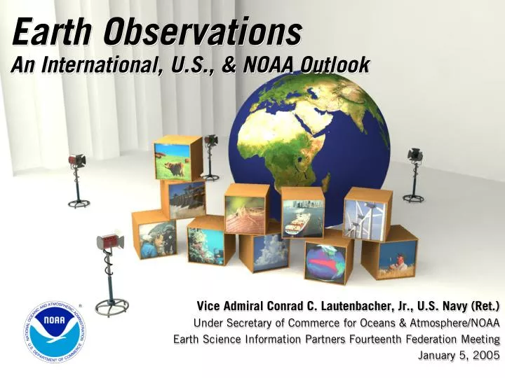
Earth Observations An International, U.S., & NOAA Outlook. Vice Admiral Conrad C. Lautenbacher, Jr., U.S. Navy (Ret.) Under Secretary of Commerce for Oceans & Atmosphere/NOAA Earth Science Information Partners Fourteenth Federation Meeting January 5, 2005. Presentation Outline.

E N D
Earth ObservationsAn International, U.S., & NOAA Outlook Vice Admiral Conrad C. Lautenbacher, Jr., U.S. Navy (Ret.) Under Secretary of Commerce for Oceans & Atmosphere/NOAA Earth Science Information Partners Fourteenth Federation Meeting January 5, 2005
Presentation Outline • The Global Earth Observation System of Systems (GEOSS) • U.S. Contribution to Global Earth Observation System of Systems • NOAA’s Role • Next Steps
Why GEOSS? • GEOSS-Global System To Meet Societal Needs • Interdisciplinary focus • An integrated international system using remote sensing & in situ systems • Foundation for sound decision-making: global, regional, & local level • Social, Economic, & Science Concerns • More than half the world’s population lives within 60 km of the shoreline, & this could rise to 3/4 by the year 2020 • More than 90% of natural disaster-related deaths occur in developing countries • 25% of Earth’s biological productivity & an estimated 80-90% of global commercial fish catch is concentrated in coastal zones • Worldwide agricultural benefits of better El Niño forecasts are conservatively estimated at $450-$550M/year
Earth Observation Summit I 34Nations 20International Organizations July 31, 2003 Washington, D.C.
Earth Observation Summit I • Declaration created ad hoc Intergovernmental Group on Earth Observations (GEO) to develop a 10-Year Implementation Plan • Four Intergovernmental Chairs: • Mr. Akio Yuki, Japan • Mr. Achilleas Mitsos, European Commission • Dr. Rob Adam, South Africa • VADM Conrad Lautenbacher, USN (Ret.), United States
Earth Observation Summit II • Held in Tokyo, Japan • Prime Minister Koizumi gave keynote address • 43 Ministers & Heads of Delegation present • 25 International Organizations represented • Adopted Framework for Global Earth Observation System of Systems (GEOSS) • Adopted Ministerial Communiqué
GEO 5, November ’04, Ottawa, Canada • GEO met most recently in Ottawa in December • 10 Year Implementation Plan (negotiated) • Reference Document (not negotiated) • Resolution of EOS-III (negotiated)
Presentation Outline • The Global Earth Observation System of Systems (GEOSS) • U.S. Contribution to Global Earth Observation System of Systems • NOAA’s Role • Next Steps
An Interagency Effort • Interagency Working Group on Earth Observations (IWGEO) • Co-chaired by Ghassem Asrar (NASA), Cliff Gabriel (OSTP), and Greg Withee (NOAA) • Comprises representatives from 15 member agencies
U.S. Contribution to GEOSS • VISION • Enable a healthy public, economy, and planet through an integrated, comprehensive, and sustained Earth observation system.
Benefits Focus Ecosystems Water Resources Natural & Human Induced Disasters Energy Resources Sustainable Agriculture & Desertification Human Health & Well-Being Oceans Weather Information, Forecasting & Warning Climate Variability & Change
Integration: 4 Perspectives Considered in U.S. Draft Plan • Policy and Planning Integration • Focus on specific societal benefits • Issue and Problem Focused Integration • Address a particular issue • Scientific Integration • Modeling of Earth processes • Technical Systems Integration • Coordination of observing system technology and data management systems • Account for observing system evolution
Architecture • Supports a range of implementation options • Addresses planned, research and operational systems • Capabilities interfaced through interoperability specifications • Inclusion of metadata and quality indicators • Continuity of observations, and instigation of new observations • Builds on existing systems and historical data • Federal Enterprise Architecture Framework
Data Management System for Earth Observations • Data Management Needs • New Systems mean 100-fold increase in data • Current systems already challenged • Development of browser and visualization systems • Interoperability through protocols and standards • Geospatial One-Stop initiative has enhanced interoperability among geographic components of government activities (led by Department of the Interior)
The Road Ahead for the U.S. Interagency Effort • Continue to engage academic, industry, and non-profit partners to guarantee plan comprehensive and useful • Workshop being planned for late Spring • Industry alliance has been formed • Update draft; e.g., incorporate public comments release final in press event in late January • Deliver final draft to international GEO process
Presentation Outline • The Global Earth Observation System of Systems (GEOSS) • U.S. Contribution to Global Earth Observation System of Systems • NOAA’s Role • Next Steps
NOAA’s Role • NOAA: Where Science Creates Value • Earth observations… • Are at the core of NOAA’s mission • Support virtually every activity we perform • NOAA has… • Observing capabilities being advanced through scientific and technological research • A broad scope of domestic and international partnerships • Commitment to transform research into useful, operational information
NOAA Observing Systems • Integrated Observations Strategic Plan—2004 • Documented initial inventory of approximately 100 observing systems measuring 286 unique environmental parameters, to support NOAA’s goals in: • Ecosystems • Weather and water • Commerce and transportation • Climate • Establishes strategic goals for integrated observations and data management
NOAA Observing Systems Architecture • A NOAA-wide enterprise approach to develop baseline and target architectures and utilize a requirements-based management process to implement most economical, efficient, and effective solutions to user observation requirements • Develop new systems • Upgrade existing systems • Obtain data from outside sources
NOAA Data Management • 100-fold increase in data will require an integrated data management system • System development coordinated with observing systems architecture • Must be continuously reviewed and updated • NOAA’s plan is underway… • FY05 – Data management systems inventory • FY06 – Analysis of commonalities and priorities • FY07 – Development of highest-priority integrating elements • FY08 – Expand integration of systems • FY09-11 – Continue evaluation and integration through spiral development
Presentation Outline • The Global Earth Observation System of Systems (GEOSS) • U.S. Contribution to Global Earth Observation System of Systems • NOAA’s Role • Next Steps
Earth Observation Summit III • Brussels, Belgium • GEO 6 • Goal to iron out last editorial issues with Implementation Plan • Agreement on Implementation Plan and Resolution • Ministers to receive Reference Document as Basis of Plan • Set up new GEO Structure and Secretariat • WMO offer to host
Near-Term Opportunities • Data Management System for Earth Observations • Improved Observations for Disaster Warnings • And better coordination of warnings—tsunami is a tragic example • Global Land Observing System • Sea Level Observing System • National Integrated Drought Information System • Air Quality Assessment and Forecast System
Tsunami - 2004 Digital Globe Imagery
Tsunami - 2004 Digital Globe Imagery
Tsunami - 2004 Digital Globe Imagery
Tsunami - 2004 Digital Globe Imagery
Tsunami - 2004 Digital Globe Imagery