Download
1 / 12
120 likes | 328 Views
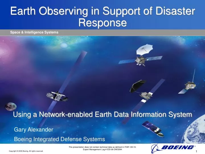
Earth Observing in Support of Disaster Response Using a Network-enabled Earth Data Information System. Gary Alexander Boeing Integrated Defense Systems. This presentation does not contain technical data as defined in ITAR 120.10. Export Management Log # IDS-06-DWS094. Established Vision.

E N D
Earth Observing in Support of Disaster ResponseUsing a Network-enabled Earth Data Information System Gary Alexander Boeing Integrated Defense Systems This presentation does not contain technical data as defined in ITAR 120.10. Export Management Log # IDS-06-DWS094
Established Vision “We are confronting a future that will require advancing our existing observing systems to the next level of Earth Observation – that is, to build a system that is international, integrated, comprehensive, and sustained that will give us the tools we need totake the pulse of the planet.” Conrad Lautenbacher U.S. Undersecretary of Commerce for Oceans and Atmosphere
Benefits of Integrated Earth Observing System • Increased speed and accuracy in decision making • Government • Industry • Better understanding and integration among: • Environmental Domains • Geographic Regions • Societal Factors • Policy Decisions • Collaboration tools • Shared Awareness • Forecasting • Disaster Preparation and Response • Resource Allocation
Key Capability: Geospatial Data Fusion Imagery, Maps, Terrain SPOT Image over DTED Seamless Fusion of multi-resolution data Bathymetry
Enabling Technology: Visualizing the Global 4-D Earth Environment
Environmental Application: Volcanoes, Earthquakes & Tsunamis AVHRR Multispectral Composite Image Mt. Popocatepetl Mexico Mt. Etna Italy Ash Particles Mt. Etna Italy Satellite Derived Ash Concentration Ash Cloud SPOT Image w/ DTED Icelandic Volcano Ash Particles Monitoring of Global Seismic Activity, Volcanic Ash Plumes and Dispersion& Wave Propagation SeismicEvents Pakistan Earthquake Event and Error Ellipse Earthquake Depths and Error Ellipses Accumulated Earthquake Events
Environmental Application: Severe Storms Severe Storm Cells Counties with Tornado Warnings Monitoring and Prediction of Weather Patterns for Severe Weather (e.g., Tornadoes) Tornado Producing Storm Counties with Severe Thunderstorm Warnings Model Simulation of Severe Storms Tornado Damage Swath Flanking Line Tornado Producing Storm
Environmental Application: Hurricanes Hurricane – IR Cloud Tops in 3D Monitoring and Prediction of Tropical Storm and Hurricane Intensities and Tracks
Operational Relevant Displays Data Discovery Collaboration Concepts Product Requirements Execution Data Fusion Network Based Integration Effectively Using GIS & Remote Sensing TJK Storage Management Access Operational Tasking Concepts Sensor Management Planning Process Development Automated Processing Improvements Assisted Processing/ Exploitation Awareness/Assessment/Understanding
Architecture for Success Open GIS Standards • Earth System Models • Oceans • Cryosphere • Land • Atmosphere • Solid Earth • Biosphere Predictions GRID computing Visualization • PolicyDecisions • Collaboration Processing • Decision Support • Discovery • Awareness • Assessment • Understanding • Earth ObservationSensors/Systems • Remote sensing • In situ • Land • Sea • Air • Space Communications Data Fusion Standards &Interoperability Observations • Management Decisions • Collaboration Actions Feedback
Key Architecture Tenants • Horizontal and vertical integration • Key to shared awareness – building a common knowledge and view • Wider coverage, more nodes (effector, sensors, decision makers) • Open Systems Architecture • Non-proprietary system with open standards for: • Life cycle supportability • Spiral development • Technology insertion • Opportunity for international participation • Full Spectrum Communications • Key to dynamic employment of effectors • Interoperable across horizontal (geographic) and vertical (sea, land, air and space)
Summary • GEOSS and GIS Standards lead the way for: • Technical Advances • Evolving interoperability standards • Improved communications • Open, flexible architecture • Network-centric, capability-driven disaster response solutions • Integrating best of industry and government • International participation • Focusing on key industrial partners strengths