Download
1 / 1
10 likes | 112 Views
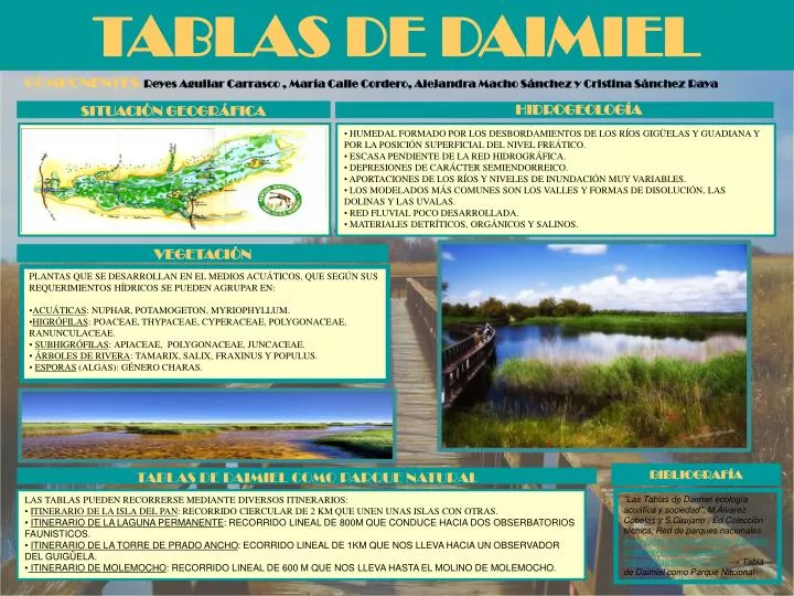
TABLAS DE DAIMIEL. COMPONENTES : Reyes Aguilar Carrasco , María Calle Cordero, Alejandra Macho Sánchez y Cristina Sánchez Raya. HIDROGEOLOGÍA. SITUACIÓN GEOGRÁFICA. HUMEDAL FORMADO POR LOS DESBORDAMIENTOS DE LOS RÍOS GIGÜELAS Y GUADIANA Y POR LA POSICIÓN SUPERFICIAL DEL NIVEL FREÁTICO.

E N D
TABLAS DE DAIMIEL COMPONENTES: Reyes Aguilar Carrasco , María Calle Cordero, Alejandra Macho Sánchez y Cristina Sánchez Raya HIDROGEOLOGÍA SITUACIÓN GEOGRÁFICA • HUMEDAL FORMADO POR LOS DESBORDAMIENTOS DE LOS RÍOS GIGÜELAS Y GUADIANA Y POR LA POSICIÓN SUPERFICIAL DEL NIVEL FREÁTICO. • ESCASA PENDIENTE DE LA RED HIDROGRÁFICA. • DEPRESIONES DE CARÁCTER SEMIENDORREICO. • APORTACIONES DE LOS RÍOS Y NIVELES DE INUNDACIÓN MUY VARIABLES. • LOS MODELADOS MÁS COMUNES SON LOS VALLES Y FORMAS DE DISOLUCIÓN, LAS DOLINAS Y LAS UVALAS. • RED FLUVIAL POCO DESARROLLADA. • MATERIALES DETRÍTICOS, ORGÁNICOS Y SALINOS. VEGETACIÓN • PLANTAS QUE SE DESARROLLAN EN EL MEDIOS ACUÁTICOS, QUE SEGÚN SUS REQUERIMIENTOS HÍDRICOS SE PUEDEN AGRUPAR EN: • ACUÁTICAS: NUPHAR, POTAMOGETON, MYRIOPHYLLUM. • HIGRÓFILAS: POACEAE, THYPACEAE, CYPERACEAE, POLYGONACEAE, RANUNCULACEAE. • SUBHIGRÓFILAS: APIACEAE, POLYGONACEAE, JUNCACEAE. • ÁRBOLES DE RIVERA: TAMARIX, SALIX, FRAXINUS Y POPULUS. • ESPORAS (ALGAS): GÉNERO CHARAS. BIBLIOGRAFÍA TABLAS DE DAIMIEL COMO PARQUE NATURAL • LAS TABLAS PUEDEN RECORRERSE MEDIANTE DIVERSOS ITINERARIOS: • ITINERARIO DE LA ISLA DEL PAN: RECORRIDO CIERCULAR DE 2 KM QUE UNEN UNAS ISLAS CON OTRAS. • ITINERARIO DE LA LAGUNA PERMANENTE: RECORRIDO LINEAL DE 800M QUE CONDUCE HACIA DOS OBSERBATORIOS FAUNISTICOS. • ITINERARIO DE LA TORRE DE PRADO ANCHO: ECORRIDO LINEAL DE 1KM QUE NOS LLEVA HACIA UN OBSERVADOR DEL GUIGÜELA. • ITINERARIO DE MOLEMOCHO: RECORRIDO LINEAL DE 600 M QUE NOS LLEVA HASTA EL MOLINO DE MOLEMOCHO. "Las Tablas de Daimiel ecología acuática y sociedad", M.Álvarez Cobelas y S.Cirujano , Ed.Colección técnica; Red de parques nacionales. www.igme.es/internet/zonas_humedas/daimiel/medio_fisico/hidr... http://tablasdedaimiel.com/ --> Tabla de Daimiel como Parque Nacional