Download
1 / 24
250 likes | 322 Views
Humidity Measurements by Aircraft of the E-AMDAR Fleet TECO 2008 Axel Hoff Deutscher Wetterdienst Observing Networks and Data Offenbach am Main Germany. ACARS Aircraft Communications Addressing and Reporting System. AMDAR = A ircraft M eteorological Da ta R elay. Enroute.

E N D
Humidity Measurements by Aircraft of the E-AMDAR FleetTECO 2008Axel HoffDeutscher WetterdienstObserving Networks and DataOffenbach am MainGermany
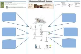
ACARSAircraft Communications Addressing and Reporting System AMDAR = Aircraft Meteorological Data Relay
Enroute 20 min after start Sampling rate = 7 min Sampling rate = 50 s Descent beginning at 18000 ft Reports: • Aircraft Identification • Date • Time (UTC) • Position • Altitude (Pressure) • Temperature • Wind Speed • Wind Direction • Water Vapor Mass Mixing Ratio Ascent Sampling rate = 40 s Descent Sampling rate = 10 s until 150 s after start Touch down
EUMETNET AMDAR(E-AMDAR) Sampling Points of 24 h over Europe BUFR: DWD (LH) FM 42: SMHI (SAS)Meteo France (AF)UKMO (BA)KNMI (KLM)
Humidity sensor enters the European AMDAR fleet 3 aircraft of the Airbus A320 family Typical daily flight program over Europe: • distance: 300 - 3000 km • up to 6 ascents + descents
SpectraSensors, WVSS-II Version 2006 • Infrared Absorption Spectrometer 2f method Tunable Diode Laser • Output: Water Vapor Mass Mixing Ratio Sensor System SEB (System Electronics Box) Hoses for connection Air Sampler with SEB Function Air Sampler Air Sampler Fuselage Sampling Tube 24 cm 24 cm SEB SEB
Installation on the Aircraft 4.8 m Exterior View 4 o‘Clock Position Air Sampler
Installation on the Aircraft FWD Skin Interior View SEB Outlet Hose, Non-Heated Inlet Hose, Heated Air Sampler Frame
Temperature Dewpoint
Verification against COSMO-EU July 200812:00 UTC EU4593 EU5331 EU6564 RMS Bias (Model - Observation)
Verification against COSMO-EU September 200812:00 UTC EU4593 EU5331 EU6564 RMSE Bias (Model - Observation)
Mixing Ratio (g/kg) RMSE Bias
Mixing Ratio (g/kg) RMSE Bias
Mixing Ratio (g/kg) RMSE Bias
Trial‘s Result of the WVSS-II Version 2006: • Constant routine operation within E-AMDAR • Relative Accuracy within ± 10 % (during the first weeks) • Drift (because of missing Laser Burn-In time) • After a few months of operation: bias of partly 10 to 20 % Rel. Humidity • Limit of detection≈ 0.05 g/kg (80 ppmv) lower 2/3 of the Troposphere • High RMSE because of limited coding in the data link from aircraft to ground
Consequences by the manufacturer SpectraSensors Inc.due to the resuls of NOAA / NWS and E-AMDAR / DWD: „Re-engineering“ → WVSS-II Version 2008 leading to • stability in the electronics • tightness of the Laser head • resulting in • - relative accuracy within ± 5 % • - detection limit< 0.015 g/kg (24 ppmv)→ complete Troposphere
Planings for further steps • Replacement of the old (2006) WVSS-II units on the Airbus A319 • Separate test flights on research aircraft, such as possibly the Airbus A340 (MOZAIC) - intercomparison sensor on board - WVSS-II house-keeping data - cyclic interchange: aircraft ↔ laboratory • Decision about more sensors • Format improvement for data link from aircraft to ground
AMDAR, quo vadis • Expansion and densification of the network on a global level: - inclusion of more airlines, - greater use of night-time starts and landings, - optimizing of the data supply. E-AMDAR / BoM • Aircraft providing additional measurable variables- humidity (to catch up with radiosondes), NWS / NOAA E-AMDAR - geometric altitude (GPS, GLONASS, GALILEO, ...), - air chemistry, aerosols, - turbulence, - icing. • Correction methods for systematic error components. • International standards for aircraft manufacturers: WMO / E-AMDAR - ex-works AMDAR configuration of the on-board software, - ex-works mechanical and electrical precautions for humidity sensor interfaces.