Download
1 / 9
100 likes | 272 Views
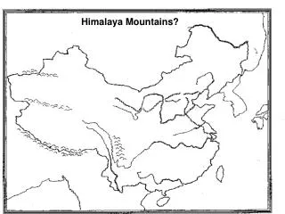
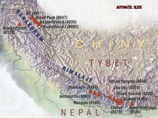
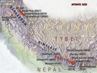
Geography of the Himalaya Region . Using the map on the next slide, identify which countries include the Himalayas, and which major rivers have their source there. http://daniellemeitiv.files.wordpress.com/2009/08/greater_himalayan_region_map.jpg. Tibet.

E N D
Geography of the Himalaya Region Using the map on the next slide, identify which countries include the Himalayas, and which major rivers have their source there. http://daniellemeitiv.files.wordpress.com/2009/08/greater_himalayan_region_map.jpg
Tibet http://www.bing.com/images/search?q=Tibet+map&view=detail&id=312432F46EF5019D2C08C1788835FEF4E68D3C44&first=0 July 28, 2011 Note: the provinces to the north and east of the Tibetan Autonomous Region also have populations of ethnic Tibetans.
Tibet Autonomous Region in relation to China & other countries http://www.bing.com/images/search?q=Tibet+map&view=detail&id=A5F03970DA00C53C1F88697F37B20533F7C290D2&first=0 July 28, 2011
Map Activities • Make a key and color each Himalayan country a different color. • Which countries border Tibet to the south? • Which country is Tibet a part of (unwillingly)? • Which is further east, Nepal or Bhutan? • Which country lies between Afghanistan & India? • How many entities end in –stan? (Stan means Place or home of)
Point out the predominantly Muslim countries that are partly in the Himalayas (hint: they all have the same last four letters) • Point out the predominantly Hindu countries that are all or partly in the Himalayas. • Point out the predominantly Buddhist countries.
Answers to previous slide: • Pakistan, Afghanistan, etc. are Muslim • India and Nepal are Hindu • Tibet, Burma and northern Nepal are Buddhist
Billions of people get their water from rivers that start in the Himalayas. What will be the impact of the Himalayan glaciers melting due to global warming?
Languages in the Himalayas • India – Indo-Aryan languages, such as Hindi, related to European languages • Nepal – 50% Nepali, which is related to Hindi, and Tibeto-Burman languages along the north side, near Tibet. • Tibet & Burma – Tibeto-Burman languages