Download
1 / 1
10 likes | 155 Views
Evidence of Strong Updrafts in Tropical Cyclones using Combined Satellite, Lightning, and High-Altitude Aircraft Observations Christopher S. Velden*, Sarah A. Monette*, Edward J. Zipser , Daniel J. Cecil ✚ , Peter G. Black # , Scott A. Braun ★ , Gerald M. Heymsfield ★

E N D
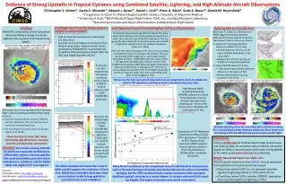
Evidence of Strong Updrafts in Tropical Cyclones using Combined Satellite, Lightning, and High-Altitude Aircraft Observations Christopher S. Velden*, Sarah A. Monette*, Edward J. Zipser, Daniel J. Cecil✚, Peter G. Black#, Scott A. Braun★, Gerald M. Heymsfield★ *Cooperative Institute for Meteorological Satellite Studies, University of Wisconsin-Madison University of Utah, ✚NASA Marshall Space Flight Center, #SAIC, Inc. and Naval Research Laboratory, ★National Aeronautics and Space Administration-Goddard Space Flight Center • Satellite-Derived Cloud Top Temperatures or Heights as a Discriminator: • Cold IR cloud-top temperatures indicate high and thick cloud. • Accurate cloud-top heights can be derived from these IR temps and a radiative transfer model developed by NOAA/NESDIS in preparation for the GOES-R Advanced Baseline Imager (ABI): the ABI Cloud Height Algorithm (ACHA). Satellite-Derived Tropical Overshooting Tops (TOTs) as a Discriminator: • Problem: • NASA ER-2 encounters severe turbulence when overflying a strong convective updraft in the eyewall of Hurricane Emily (2005) . Lightning Data as a Discriminator: • Many past TC studies (i.e. Molinari et al. 1999) suggest correlations between lightning and intense eyewall convection. Two networks able to sense over oceans: • Vaisala VLF long-range detection network (available for TC Emily) • 30-50% detection efficiency in the region of Emily, depending on day versus night • Median flash location accuracy of • 8 (10) km for daytime (nighttime) • Vaisala GLD360 (used for TC Karl) • ~70% cloud-to-ground flash detection efficiency in the region of Karl • Median flash location accuracy between 5 and 10 km Convective overshooting tops (OTs) are clouds that grow above their ambient anvil and/or exceed the equilibrium level. They also often penetrate the tropopause. OTs are generally associated with localized buoyancy and updrafts of significant velocity, which can produce turbulence (Lane et al. 2012). TOTs are the tropical relatives of OTs but are less-sampled, and therefore much less is known about them. They can be detected in IR imagery by an automated method developed at UWisc.- CIMSS (Monette and Velden 2012). The algorithm identifies local relative minima in the brightness temperature (BT) field and applies empirically-determined thresholds to distinguish the TOT from its surrounding anvil and determine its strength. Cloud pixel minima at least 4 K colder than their surrounding anvil (BTD ≥ 4) are flagged as TOTs. At the time the ER-2 experienced turbulence overflying Emily, it had a 15,000 ft. vertical clearance over FL490 (49,000 kft) cloud tops. We can use the high-level aircraft observations as an independent source to validate the satellite TOT signatures, and help us better understand what they imply. Time of Turbulence High Altitude MMIC Sounding Radiometer (HAMSR) onboard the Global Hawk identifies a narrow band of high reflectivity extending to ~12 km at thelocation of an identified TOT (estimated at 14 km). • This single occurrence prompted the following flight rules for subsequent NASA Global Hawk missions: • Aircraft should maintain at least 10000 ft. vertical separation from convective cloud tops with reported lightning. • No over-flight of cumulus-type cloud tops higher than FL500. • These restrictions mean that many potentially safe HS3 science missions could be unnecessarily constrained. • Question:Can remote sensing methods be used with reasonable confidence to differentiate regions of strong updrafts that could potentially cause over-storm turbulence vs. conditions safe for Global Hawk over-flights of TC core regions? However, the Global Hawk overflew FL560 (56,000 kft) cloud tops in Matthew (2010) with only 5,000 ft. vertical clearance, but did not record any significant turbulence. GH Multiple lightning strikes are associated with turbulence-causing TOT in Emily (despite lower detection efficiency). None observed in Karl during which the Global Hawk experienced a smooth flight. Comparison of TOT Brightness Temperature Difference (the TOT magnitude or “strength”) to ER-2 Doppler Radar measured updraft speeds in tropical cyclone conditions (from Heymsfield et al. (2010)) yields a moderate correlation. Conclusions: Using a combination of satellite-based image analysis tools and lightning data, we are better able to identify convective signatures likely to be associated with locally strong updrafts in TCs which could potentiallylead to turbulence. Result: New Global Hawk over-flight rules: Aircraft should maintain at least 5000 ft. vertical separation from significant convective cloud tops except: Cloud tops above FL500: Do not approach reported significant lightning activity or TOTs within 25 nm. Cloud tops below FL500: maintain 10000 ft. separation from reported significant lightning or TOTs. • Many factors contribute to the unexplained variance and therefore low precision, such as the exact timing and location mismatches between the plane and satellite sampling. But the TOTs can discriminate tropical convection with associated significant updraft velocities to a certain degree. In tandem with cold ACHA cloud-top heights, this begins to become more useful information. The above example and many other cases in GRIP and HS3 support the contention of Cecil et al. (2010) that cold (high) cloud tops alone can not deduce locally strong updrafts or associated over-cloud turbulence. Contacts: Christopher Velden: chrisv@ssec.wisc.edu Sarah Monettesarah.monette@ssec.wisc.edu Support: NASA Hurricane Science Research Program