Download
1 / 16
170 likes | 435 Views
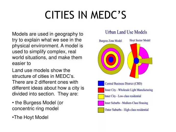
CITIES IN MEDC’S. Models are used in geography to try to explain what we see in the physical environment. A model is used to simplify complex, real world situations, and make them easier to

E N D
CITIES IN MEDC’S • Models are used in geography to try to explain what we see in the physical environment. A model is used to simplify complex, real world situations, and make them easier to • Land use models show the structure of cities in MEDC’s. There are 2 different ones with different ideas about how a city is divided into section. They are: • the Burgess Model (or concentric ring model • The Hoyt Model
Zone A: Central Business District; contains the major shops, offices and entertainment facilities.Zone B: Inner city area (twilight zone). This is an area of old housing and light manufacturing industry. This area dates back to the Industrial revolution when it filled with coal-fired factories and tenement housing blocks.Zone C: Low class residential. This is an area of poor quality housing, although the conditions are better than in Zone 2.Zone D: Medium class residential. This is an area of housing which was built between the wars. It is mainly semidetached housing and council estates.Zone E: High class residential (commuter zone). This is an area of expensive housing on the outskirts of the city. It also stretches in to the countryside beyond the city.The concentric ring model (below) was devised by Burgess. It split the land use of the city into rings, starting from the centre. The idea was that urban areas grow equally in all directions, with the oldest, most dense housing being found closest to centre
How true is the Burgess Model? • As with many models in geography, there are limits to the Burgess model: • The model is now quite old and was developed before the advent of mass car ownership. • New trends have developed in working and housing trends since the model was developed. Many people now choose to live and work outside the city on the urban fringe - a phenomenon which is not reflected in the Burgess model. • Every city is different. No 'typical city' model is perfect, because there is really no such thing as a typical city!