Download
1 / 15
150 likes | 352 Views
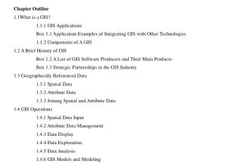
CHAPTER 1 INTRODUCTION 1.1 What Is a GIS? 1.1.1 GIS Applications 1.1.2 Components of a GIS Box 1.1 More Interesting Examples of GIS Applications 1.2 A Brief History of GIS Box 1.2 A List of GIS Software Producers and Their Main Products 1.3 Geographically Referenced Data 1.3.1 Spatial Data

E N D
CHAPTER 1 INTRODUCTION 1.1 What Is a GIS? 1.1.1 GIS Applications 1.1.2 Components of a GIS Box 1.1 More Interesting Examples of GIS Applications 1.2 A Brief History of GIS Box 1.2 A List of GIS Software Producers and Their Main Products 1.3 Geographically Referenced Data 1.3.1 Spatial Data 1.3.2 Attribute Data 1.3.3 Joining Spatial and Attribute Data 1.4 GIS Operations 1.4.1 Spatial Data Input 1.4.2 Attribute Data Management 1.4.3 Data Display 1.4.4 Data Exploration 1.4.5 Data Analysis 1.4.6 GIS Models and Modeling 1.5 Organization of This Book 1.6 Concepts and Practice Key Concepts and Terms Review Questions
Applications: Introduction Task 1: Introduction to ArcCatalog Task 2: Introduction to ArcMap Task 3: Introduction to ArcInfo Workstation Challenge Question References
Figure 1.1 An example of geographically referenced data. The street network is based on a plane coordinate system. The box on the right lists the x- and y-coordinates of the end points and other attributes of a street segment
Figure 1.2 The vector data model uses x-, y-coordinates to represent point features (a), and the raster data model uses cells in a grid to represent point features (b).
Figure 1.3 When we use the add data button to add a layer to a map, we are actually using the AddLayer method on the IMap interface that the Map class supports.
Figure 1.4 A classification of data formats used in ESRI software by topology and data model.
Figure 1.5 An example of the TIN model.
Figure 1.6 An example of the regions model. Two regions, one for burned areas in 1919 and the other in 1929, overlap each other in some areas. Each region is also comprised of spatially disjoint parts.
Figure 1.7 An example of the dynamic segmentation model. Rest areas are plotted as point features on highway routes in Washington State.
Figure 1.8 A classification of GIS operations.
Figure 1.9 A vector-based overlay operation combines spatial data and attribute data from different layers to create the output.
Figure 1.10 A raster data operation with multiple rasters can take advantage of the fixed cell locations.
U.S. Department of Labor: emerging fields http://www.careervoyages.gov/geospatialtechnology-main.cfm U.S. Geological Survey National Map http://nationalmap.usgs.gov U.S. Census Bureau On-Line Mapping Resources http://www.census.gov/geo/www/maps/ U.S. Forest Service: technologies for mapping forest fires http://www.fs.fed.us/fire/tools_tech/ U.S. Department of Housing and Urban Development http://www.hud.gov/offices/cio/emaps/index.cfm National Institute of Justice: crime mapping http://www.ojp.usdoj.gov/nij/maps/ Federal Emergency Management Agency: flood insurance rate map http://www.fema.gov/fhm/mm_main.shtm Larimer County, Colorado: land records http://www.larimer.org/ Microsoft http://www.microsoft.com/ Oracle http://www.oracle.com/
IBM: Spatial DataBlade http://www-306.ibm.com/software/data/informix/blades/spatial/ National Association of Realtors http://www.realtor.com/ Keyhole http://www.keyhole.com/ Dodegeball http://www.dodgeball.com/ Eyebeam: Fundrace http://www.fundrace.org ESRI http://www.esri.com/ Autodesk http://www3.autodesk.com/ Land Management Information Center at Minnesota Planning: EPPL7 http://www.lmic.state.mn.us/EPPL7/ Baylor University: GRASS http://grass.baylor.edu/
Clark Labs: IDRISI http://www.clarklabs.org/ International Institute for Aerospace Survey and Earth Sciences, the Netherlands: ILWIS http://www.itc.nl/ilwis/ Manifold.net http://www.manifold.net/ MapInfo Corporation http://www.mapinfo.com/ Keigan Systems: MFworks http://www.keigansystems.com/ Intergraph Corporation: MGE, GeoMedia http://www.intergraph.com/ Bentley Systems, Inc: Microstation http://www2.bentley.com/ PCI Geomatics: Geomatica http://www.pcigeomatics.com/ Caliper Corporation: TransCAD, Maptitude http://www.caliper.com/