Download
1 / 8

E N D
The scientists are outlining a gloomy image of the future, future that seemingly isn’t too bright for Antarctica, which in our opinion is one of the most spectacular ecosystems of our planet. The fascination of Antarctica was the main reason for which we wish to take part at this project. • All the pictures that are presented on your web site are truly interesting and two of them have really impressed us and that will by the pictures of Mount Takahe and the one of the Mesa mountain in the McKelvey Valley of the Antarctic Dry Valleys. For us was quite impressive that in Antarctica do exist active volcanoes and dry valleys. Furthermore, these two photos raised in our minds several questions like: How could exist active volcanoes in such a place like Antarctica? Or Are the dry valleys an effect of the global warming? Or If Antarctica is moving are the other continents doing the same?
The picture we have chosen to explore and to find more about of that region was the one of the Mount Takahe. We think this area should be further observed because it offers the possibility of better understanding this spectacular ecosystem and, furthermore, the public will become more interested in investigating this continent. • Nature has proved us, through this image that contrasts, such as worm and frozen, can be found together in an unexpected place like Antarctica. That is why, with the help of new technologies and a more detailed research of this volcano, specialists could discover other unbelievable associations between two or more of nature’s creations. As we all know, spectacular discoveries have always represented the key towards a successful beginning from the public point of view and exploring the depths of Antarctica could easily become such an example. A better knowledge and understanding of this continent could bring great satisfactions for our species, especially in what concerns our future. One of the most present problems nowadays is represented by global warming, which could probably be prevented if we were aware of the importance of maintaining a balance in Antartica’s ecosystems. That’s why we think that a more detailed study of this continent could help us prevent other possible threats.
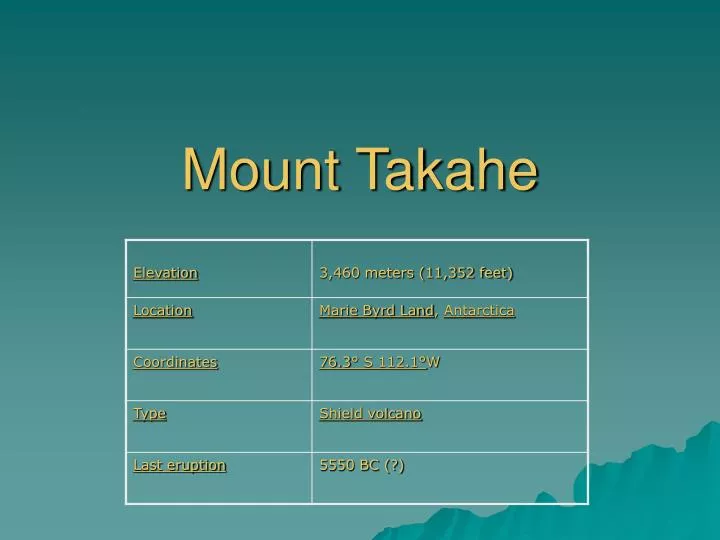
We know that Mount Takahe is an isolated shield volcano in eastern Marie Byrd Land with an 8-km-wide summit caldera. The massive 780 cu km volcano displays a conical, youthful morphology, and the oldest dated rocks are only 0.31 million years old. Three samples were too young to date by Potassium-Argon, and some tephra layers younger than 30,000 years in the Byrd Station ice core are thought to have originated from Mount Takahe. Two early Holocene phreatomagmatic tephra layers in the Antarctic ice core were attributed to Mount Takahe (Palais et al., 1988). The latest stage of activity at Mount Takahe constructed cinder cones on the upper southern flanks and tuff cones and cinder cones on the lower SW and NE flanks. We also know that this volcano may have last erupted during the Holocene, and thus is probably still active, but presently dormant.
Under the volcano there can be many types of rocks, as eruptions can throw them towards the surface. The volcanic rocks can also scientifically prove the age of the region and the existing iced water at the surface can be relevant in the research of micro-organisms that had existed there before the ice formed. • After we done some researches on this topic we found out that the ice feature was created by the interaction of molten rock and meltwater from the surrounding glacier and the encapsulation of the volcanic activity by the glacier ice. In Iceland, where landforms formed from subglacial volcanic activity abound, two distinct types can be recognized: (1) landforms resulting from central eruptions of basaltic lava, and (2) landforms resulting from linear eruptions of basaltic lava (Williams et al., 1983b). Volcanic landforms formed in this way are composed of hyaloclastite breccias and pillow lavas, characteristic of the so-called Móberg Formation in Icelandic. The linear landforms are called subglacial or móberg ridges, especially well depicted on Plate G-15 in the region between the southwestern part of Vatnajökull and the northeastern part of Myrdalsjökull. The subglacial landform that results from a subglacial eruption is called a table mountain ("stapi" in Icelandic).
We really enjoyed working together at this project and we are looking forward to find out more about it