Download
1 / 13
130 likes | 190 Views
Paulo Leitão, Henrique Coelho. Towards an Operational Model for the Tagus Estuary. Rodrigo Fernandes, Ramiro Neves, Frank Braunschweig, João Silva, Susana Nunes, Madalena Santos, Ângela Canas e João Nogueira. Overview. Tagus estuary Motivation System Design End user results

E N D
Paulo Leitão, Henrique Coelho Towards an Operational Model for the Tagus Estuary Rodrigo Fernandes, Ramiro Neves, Frank Braunschweig, João Silva, Susana Nunes, Madalena Santos, Ângela Canas e João Nogueira
Overview • Tagus estuary • Motivation • System Design • End user results • Present situation • Conclusions/Future Work
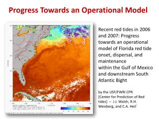
2 million people Tagus estuary M2 - 1 m Area = 320 km2 Average river flow = 300 m3/s Catchment area = 80.500 km2
Motivation • Monitoring programs (supported by SANEST, SIMTEJO – 2 private companies responsible for management of waste water from 1.5 million people); • The Water Framework Directive; • Validation in continuum of our numerical modeling system (http://www.mohid.com)
System Design Real-time modelling Atmospheric + Hydrodynamics Real-time field data Field Campaigns Validation Databases Results Publication (depending on target public)
MOHID System Structure MOHID Land MOHID Soil Executable Library Mohid Base 3 Soil modules Basin Delineator Digital Terrain Creator MOHID Water Interprocess Communication Soil, Soil Properties,... Triangulator River Network Mohid Base 2 Grid and Atmosphere modules 0D Main Horizontal Grid,Vertical Grid, Atmosphere, Advection Diffusion, ... Mohid Base 1 Process, IO and Function modules Global Data, Water Quality, Sediment Quality, EnterData, HDF, Functions, Time, LUD, Triangulation, Time Series, ...
Discharges from rivers / WWTP’s Atmospheric forcing (MM5) Global tide solution FES95.2 Tagus estuary (dx = 300 m) Portuguese Coast (dx = 2 km) WWTP Discharge Cascais (dx = 50 m) Atmospheric model –> http://meteo.ist.utl.pt Modelling Methodology (Nested Models)
Automatic stations network Acoustic Doppler Current Meter Profiler Automatic atmospheric station • Buoys – automatic acquisition stations: • Velocities and pressure • Temperature, salinity • Clorofile, turbidity, oxygen, pH Cascais Carcavelos
Conclusions/Future Work • The system started producing modeling results on a daily basis in March of 2003; • The links between models, data acquisition systems, data bases and web applications are implemented;
Conclusions/Future Work • The system is working • In the future it needs: • Implementation of data assimilation modules • Daily statistical analysis of the model accuracy • To find other end users (ex: harbor)