Download
1 / 43
450 likes | 597 Views
Atmospheric Moisture and Stability. Lecture 7 October 21, 2009. Homework #2 Comments. Winds are nearly geostrophic in the upper levels of the atmosphere because there is less friction. . Homework #2 Comments.

E N D
Atmospheric Moisture and Stability Lecture 7 October 21, 2009
Homework #2 Comments • Winds are nearly geostrophic in the upper levels of the atmosphere because there is less friction.
Homework #2 Comments Fastest wind at point b because PGF is largest (isobars closely spaced together) • Friction in the opposite direction of wind • CF always at 90° perpendicular to wind • Wind flows across isobars in lower levels (not in geostrophic balance) Fr CF PGF Wind
Review from last week • Energy is the ability or capacity to do work on some form of matter • Kinetic energy – the energy an object possesses as a result of its motion KE = ½ mv2 • 1stLaw of Thermodynamics– Energy cannot be created or destroyed. • Energy lost during one process must equal the energy gained during another
Review • Therefore the 1st law states that heat is really energy in the process of being transferred from a high temperature object to a lower temperature object. • Heat can be transferred by: • Conduction: transfer of heat from molecule to molecule within a substance by direct contact • Convection: the transfer of heat by the mass movement of a fluid in the vertical direction (up and down) • Advection: the transfer of heat in the horizontal direction • Radiation: the transfer of heat through electromagnetic wave energy
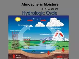
Water is responsible for many of Earth’s natural processes http://www.srh.weather.gov/jetstream/atmos/hydro.htm
Water can exist in all three phases in our atmosphere • What atmospheric variable do we use to quantify the amount of water in any given volume of air at one time? • Answer: Moisture
Ways to measure the moisture content of the atmosphere • Absolute Humidity- The ratio of the mass of water vapor to the volume occupied by a mixture of water vapor and dry air. • Specific Humidity- The mass of water vapor / unit mass of air, including the water vapor. • Mixing Ratio- ratio of the mass of water vapor per kg of dry air • Saturation Mixing Ratio- mass of water vapor when a parcel is saturated / mass of dry air in the parcel. • Vapor Pressure- Pressure of water vapor constituent of the atmosphere. • Saturation Vapor Pressure- The pressure of water vapor constituent when the atmosphere is saturated.
The variables we will refer to most • Mixing Ratio- ratio of the mass of water vapor per kg of dry air (does not change with temperature) • Relative Humidity- Vapor Pressure/ Saturation vapor pressure • Dew Point Temperature- The temperature to which a given air parcel must be cooled at constant pressure and constant water vapor content in order for saturation to occur.
There are only TWO ways to saturate the air (or increase the relative humidity) 1. Add more water vapor to the air 2. Cool the air until its temperature is closer to the dew point temperature Remember the water vapor molecules are moving faster in warm air and less likely to stick together and condense. If air cools to the dew point temperature, there is saturation.
Moisture • An air parcel with a large moisture content has the potential for that parcel to produce a great amount of precipitation. - Air with a mixing ratio of 13 g/kg will likely rain a greater amount of water than air with a mixing ratio of 6 g/kg.
Two parcels of air: PARCEL 1:Temperature = 31 oF, Dew point = 28 oF PARCEL 2:Temperature = 89 oF, Dew point = 43 oF Parcel 2contains more water vapor than Parcel 1, because its dew point is higher. Parcel 1has a higher relative humidity, because it wouldn’t take much cooling for the temperature to equal the dew point! Thus,Parcel 1is more likely to become saturated. But if it happened that both parcels became saturated then Parcel 2 would have the potential for more precipitation. RH is not simply equal to the dew point divided by the temperature but is a good representation.
Moisture and the Diurnal Temperature Cycle • Review: Water has a high heat capacity (it takes lots of energy to change its temperature) • As a result, a city with a dry climate (like Sacramento, CA) will have a very large diurnal (daily) temperature cycle • A city with high water vapor concentration (like Key West, FL) will have a small diurnal cycle Late July averages: Sacramento:~94/60 Key West:~90/79
The other key component to the hydrologic cycle- Stability • What is stability? • Stability refers to a condition of equilibrium • If we apply some perturbation to a system, how will that system be affected? • Stable: System returns to original state • Unstable: System continues to move away from original state • Neutral: System remains steady after perturbed
Stability Example Stable: Marble returns to its original position Unstable: Marble rapidly moves away from initial position
Stability How does a bowl and marble relate to the atmosphere?? • When the atmosphere is stable, a parcel of air that is lifted will want to return back to its original position: http://www.chitambo.com/clouds/cloudshtml/humilis.html
Stability Cont. • When the atmosphere is unstable (with respect to a lifted parcel of air), a parcel will want to continue to rise if lifted: http://www.physicalgeography.net/fundamentals/images/cumulonimbus.jpg
What do we mean by an air parcel? • Imaginary small body of air a few meters wide • Can expand and contract freely • Does not break apart • Only considered with adiabatic processes - External air and heat cannot mix with the air inside the parcel • Space occupied by air molecules inside parcel defines the air density • Average speed of molecules directly related to air temperature • Molecules colliding against parcel walls define the air pressure inside
Buoyancy and Stability • Imagine a parcel at some pressure level that is held constant, density remains the same so the only other variable that is changing is temperature. (REMEMBER: the Ideal Gas Law) • So if ρparcel < ρenv. Parcel is positively buoyant • In terms of temperature that would mean: T of parcel > T of environment – buoyant! (unstable) T of parcel < T of environment – sink! (stable) T of parcel = T of environment – stays put (neutral)
Atmospheric Stability This is all well and good but what about day to day applications?
Review: Atmospheric Soundings • Vertical “profiles” of the atmosphere are taken at 0000 UTC (7 AM CDT) and 1200 UTC (7 PM CDT) at ~80 stations across the country, and many more around the world. Sometimes also launched at other times when there is weather of interest in the area. • Weather balloons rise to over 50,000 feet and take measurements of several meteorological variables using a “radiosonde.” • Temperature • Dew point temperature • Wind • - Direction and Speed • Pressure http://www2.ljworld.com/photos/2006/may/24/98598/
Vertical Profile of Atmospheric Temperature allows us to assess stability of the atmosphere
Lapse Rates • Lapse Rate: The rate at which temperature decreases with height (Remember the inherent negative wording to it) • Environmental Lapse Rate: Lapse rates associated with an observed atmospheric sounding (negative for an inversion layer) • Parcel Lapse Rate: Lapse rate of a parcel of air as it rises or falls (either saturated or not) • Moist Adiabatic Lapse Rate (MALR): Saturated air parcel • Dry Adiabatic Lapse Rate (DALR): Dry air parcel
DALR • Air in parcel must be unsaturated (Relative Humidity < 100%) • Rate of adiabatic heating or cooling = ~10°C for every 1000 meter (1 kilometer) change in elevation • Parcel temperature decreases by about 10° if parcel is raised by 1km, and increases about 10° if it is lowered by 1km
MALR • As rising air cools, its RH increases because the temperature approaches the dew point temperature, Td • If T = Td at some elevation, the air in the parcel will be saturated (RH = 100%) • If parcel is raised further, condensation will occur and the temperature of the parcel will cool at the rate of about 6.5°C per 1km in the mid-latitudes
DALR vs. MALR • The MALR is less than the DALR because of latent heating • As water vapor condenses into liquid water for a saturated parcel, LH is released, lessening the adiabatic cooling Remember no heat exchanged with environment
Absolute Stability • The atmosphere is absolutely stablewhen the environmental lapse rate (ELR) is less than the MALR ELR < MALR <DALR • A saturated OR unsaturated parcel will be cooler than the surrounding environment and will sink, if raised
Absolute Stability • Inversion layers are always absolutely stable • Temperature increases with height • Warm air above cold air = very stable
Absolute Instability • The atmosphere is absolutely unstablewhen the ELR is greater than the DALR ELR > DALR > MALR • An unsaturated OR saturated parcel will always be warmer than the surrounding environment and will continue to ascend, if raised
Conditional Instability • The atmosphere is conditionally unstablewhen the ELR is greater than the MALR but less than the DALR MALR < ELR < DALR • An unsaturated parcel will be cooler and will sink, if raised • A saturated parcel will be warmer and will continue to ascend, if raised
Conditional Instability • Example: parcel at surface • T(p) = 30°C, Td(p) = 14°C (unsaturated) • ELR = 8°C/km for first 8km • Parcel is forced upward, following DALR • Parcel saturated at 2km, begins to rise at MALR • At 4km, T(p) = T(e)…this is the level of free convection (LFC)
Conditional Instability • Example continued… • Now, parcel will rise on its own because T(p) > T(e) after 4km • The parcel will freely rise until T(p) = T(e), again • This is the equilibrium level (EL) • In this case, this point is reached at 9km • Thus, parcel is stable from 0 – 4km and unstable from 4 – 9km EL LCL
Rising Air • Consider an air parcel rising through the atmosphere • The parcel expands as it rises • The expansion, or work done on the parcel causes the temperature to decrease • As the parcel rises, humidity increases and reaches 100%, leading to the formation of cloud droplets by condensation
Rising Air • If the cloud is sufficiently deep or long lived, precipitation develops. • The upward motions generating clouds and precipitation can be produced by: • Convection in unstable air • Convergence of air near a cloud base • Lifting of air by fronts • Lifting over elevated topography
Lifting by Convection • As the earth is heated by the sun, thermals (bubbles of hot air) rise upward from the surface • The thermal cools as it rises, losing some of its buoyancy (its ability to rise) • The vertical extent of the cloud is largely determined by the stability of the environment
Lifting by Convection • A deep stable layer restricts continued vertical growth • A deep unstable layer will likely lead to development of rain-producing clouds • These clouds are more vertically developed than clouds developed by convergence lifting
Lifting by Convergence • Convergence exists when there is a horizontal net inflow into a region • When air converges along the surface, it is forced to rise
Lifting by Convergence • Large scale convergence can lift air hundreds of kilometers across • Vertical motions associated with convergence are generally much weaker than ones due to convection • Generally, clouds developed by convergence are less vertically developed
Lifting due to Topography • This type of lifting occurs when air is confronted by a sudden increase in the vertical topography of the Earth • When air comes across a mountain, it is lifted up and over, cooling as it is rising • The type of cloud formed is dependent upon the moisture content and stability of the air
Lifting Along Frontal Boundaries • Will discuss origin more in detail next week as we begin to discuss cyclones and fronts