Download

1 / 22
230 likes | 351 Views
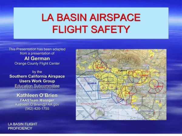
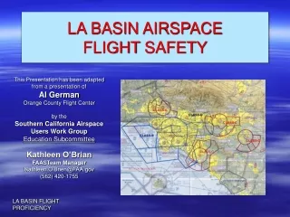
LA BASIN AIRSPACE FLIGHT SAFETY. This Presentation has been adapted from a presentation of Al German Orange County Flight Center by the Southern California Airspace Users Work Group Education Subcommittee Kathleen O’Brian FAASTeam Manager Kathleen.O’Brien@FAA.gov (562) 420-1755.

E N D
LA BASIN AIRSPACEFLIGHTSAFETY This Presentation has been adapted from a presentation of Al GermanOrange County Flight Centerby the Southern California Airspace Users Work GroupEducation SubcommitteeKathleen O’Brian FAASTeam Manager Kathleen.O’Brien@FAA.gov(562) 420-1755
LA BASIN – FLIGHT SAFETY • FAA AIRSPACE CLASSIFICATION • TERMINAL CHART CONTENTS • AIR CARRIER TRAFFIC • VFR AIRSPACE RESTRICTIONS • VFR AIRSPACE • LA CLASS-B ROUTES • PRACTICE AREAS • CONFLICTS – VFR & AIR CARRIER TRAFFIC
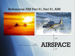
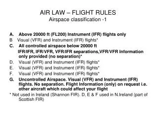
CONTROLLED AIRSPACE • Class A • 18,000 Feet to FL600 • IFR Required • Class B • Surface to 10,000 Feet (or as charted) • Contains all IFR Approaches • ATC Clearance Required for VFR • Transponder Mode C VEIL (30 NM – 10,000 Feet) • Class C • Surface to 4,000 Feet (or as charted) • 5 NM Core – 10NM Shelf • Required by Number of IFR Operations • Two-Way Radio Communication Required • Class D • Surface to 2,500 Feet (or as charted) • Operational Control Tower • Two-Way Radio Communications Required • Class E • Controlled Airspace not Class A, B, C, D • Class E Charted to contain IFR procedures • UNCONTROLLED AIRSPACE • Class G -- Airspace not Class A, B, C, D, E
FAA AIRSPACE CLASSIFICATIONS Altitude Flight Visibility Distance From Clouds Class A Not Applicable Not Applicable Class B 3 Statute Miles Clear of Clouds Class C 3 Statute Miles 500’ Below - 1000’ Above 2000’ Horizontal Class D 3 Statute Miles 500’ Below - 1000’ Above 2000’ HorizontalClass E - Less than 10,000 Feet 3 Statute Miles 500’ Below - 1000’ Above 2000’ Horizontal At/Above 10,000 Feet 5 Statute Miles 1000’ Below – 1000’ Above 1 Statute Mile HorizontalClass G – 1200’ or less above the surface Day * 1 Statute Mile Clear of Clouds Night* 3 Statue Miles 500’ Below – 1000’ Above * Except as provided in 91.155(b) 2000 Horizontal More that 1200’ – Less than 10,000’ MSL Day 1 Statute Mile 500’ Below – 1000’ Above Night 3 Statute Miles 2000’ Horizontal More than 1200 ‘ AGL and 5 Statute Miles 1000’ Below – 1000’ Above more than 10,000’ MSL 1 Statute Mile Horizontal
Special Use Type Airspace Prohibited Area Established for Security or National Welfare No Entry Restricted Area Unusual Hazards to Aircraft Artillery Firing, Aerial Gunnery, Guide Missals Active – No Entry Not Active – ATC will Coordinate IFR Warning Area Restricted Areas in International Airspace Beyond the 3 Mile Limit Military Operations Area Air Combat Tactics, Air InterceptsMilitary Training Routes Formation Training & Low Altitude Tactics Authorization NOT Required but Recommended IFR – ATC Will Coordinate Alert Area High Volume Pilot Training – Aerobatics Airport Advisory Area 10 Statute Mile Radius – Flight Service Provides Advisories Temporary Flight Restrictions Authorization Required – Designated by NOTAM Parachute Jump Areas Caution Published VFR Route Typically VFR Routes through Class B Airspace
FDC 3/1862 FDC SPECIAL NOTICE This notice modifies flight restrictions previously issued in FDC NOTAM 2/1099. To comply with statutory mandates detailed in Section 352 of Public Law 018-7 effective 0303061100 UTC (0600 Local 3-6-03) until further notice. Pursuant to 14 CFR Section 99.7, special security instructions, commencing one hour before the time of event until one hour after the end of the event, all aircraft and parachute operations are prohibited at and below 3000 feet AGL within a three nautical mile radius of any stadium having a seating capacity of 30,000 or more people in which a major league baseball, national football league, NAA Division One Football, or Major League Speedway event is occurring. All previously issued wavers to FDC 2/1099 are rescinded. *Flight Data Center NOTAM : Underline emphasis added FDC* 3/1862 SPECIAL NOTICE
DISNEYLAND FDC 3/2123 2LA CA. FLIGHT RESTRICTIONS ANAHEIM, CA. EFFECTIVE 0303182000 UTC [MARCH 18 AT 1200 LOCAL] UNTIL FURTHER NOTICE. PURSUANT TO RESTRICTIONS DETAILED IN SECTION 352 OF PUBLIC LAW 108-7, AND 14 CFR SECTION 99.7. SPECIAL SECURITY INSTRUCTIONS. AIRCRAFT FLIGHT OPERATIONS ARE PROHIBITED AT AND BELOW 3,000 FEET AGL WITHIN A 3 NAUTICAL MILE RADIUS OF THE DISNEYLAND THEME PARK (334805N/1175517W OR THE SEAL BEACH /SLI/ 067 DEGREE RADIAL AT 6.7 MILES. THIS RESTRICTION DOES NOT APPLY TO (A) THOSE AIRCRAFT AUTHORIZED BY ATC FOR OPERATIONAL OR SAFETY PURPOSES, INCLUDING AIRCRAFT ARRIVING OR DEPARTING FROM AN AIRPORT USING STARDARD AIR TRAFFIC PROCEDURES*.* Emphasis added for purposes of instruction
TERRAIN 1548
HOT SPOTS NUMBER & NAME • 1. Magic Mountain area • 2. EMT arrival area • 3. Corona airport arrival conflicts with Santa Ana Canyon traffic • 4. KAHYO intersection area with air carriers descending for SNA/LGB • 5. EVA and EMMY oil platforms • 6. ALBAS intersection instrument practice with air carrier on TANDY arrival • 7. San Pedro practice area with air carrier on LGB departure • 8. Area north of LGB with multiple operations including helicopters (police,traffic watch, commercial) • 9. Santa Monica area with departures/arrivals, transitions to LAX crossings • 10. Semi Valley with complex air carrier departures/arrivals in a narrow area for VFR traffic
HOT SPOT DESCRIPTIONS • #1 Semi Valley VFR and Air Carrier Transitions : The area over Semi Valley that is another hotspot is where the Fernando 5 Arrival to Burbank brings jet traffic down to 5,000 ft. over the Semi Valley practice area; which is getting more and more popular. There is also a long ILS to Oxnard that starts feeding just west of this practice area. Finally, ATC is vectoring airplanes for the VOR A approach to VNY in the area. Anytime there is instrument training, airliners, and pilot training in general there is a hotspot. • #2 El Monte Arrival : The hotspot northeast of El Monte lies along the 210 FWY. It is centered over a popular helicopter and fixed wing practice area, the Santa Fe Dam. It is near a common VFR reporting point for EMT. It is an area squeezed by the mountains to the North and the Class B airspace to the South. It is located near the intersections of the 605 FWY and both the 210 and 10 Freeways hosting a lot of traffic watch aircraft as well as banner towers over the Toyota Irwindale Speedway at the intersection of the 10 and 210 freeways. • #3 Corona Airport Conflict w/ Santa Ana Canyon : The hotspot located near the Corona airport if it could be drawn would be elongated reflecting the traffic along the 91 FWY in a pass just east of Corona, squeezed by mountains, airspace, and often weather forcing compression along a popular navigation route. Finally, there are numerous small general aviation airplanes from both Corona and Chino airports. If they get high they are mixed with traffic form Ontario departing to the South and eventually East toward TRM, John Wayne headed to Las Vegas, and lots of airplanes leaving the Southern airports of LA and Orange County east to Palm Springs, and out of the area.
HOT SPOT DESCRIPTIONS • #4 KAHYO Intersection : This hot spot is a high altitude hotspot on near the KAHYO intersection which is a focal point for Jet aircraft arriving from both over Twenty-nine Palms and Hector en route to John Wayne and Long Beach. The altitude of concern is between 7,000 ft. and 10,000 ft. There is a mix of airplanes without Mode C transponders from Corona, Chino and Hemet, Airliners with pilot’s heads down programming boxes for landing, and skydivers. There is a lot of ATC confusion because the arrival terminates to radar vectors most of the time after KAHYO to the airports the KAHYO Arrival supports. • #5 EVA and EMMY Oil Platforms : The hotspot off shore near the Eva and Emmy oil platforms is created by the volume and mix of traffic arriving to Long Beach and John Wayne. The Huntington Beach pier is a popular reporting point to SNA, the practice area noted on the chart, and the fact that LGB is one of the most popular airports for practice instrument approaches and the area and the normal downwind to the ILS 30 approach to LGB runs right through this area all contribute to this hotspot. Mix these issues with … • #6 ALBAS Intersection TANDY Arrival : … the jet arrivals from over Catalina on the TANDY 3 arrival to LGB, SNA, and Torrance and these two designated hotspots can get you out of the frying pan into the fire very quickly. The ALBAS intersection sits 5 miles off the Huntington Beach pier; far enough off the shore line to be out of most coastal VFR traffic but close enough to LGB and SNA for good holding pattern training for IFR students. The combination of “head down in the cockpit” with the constant TANDY 3 Arrival traffic makes these areas hot spot issues throughout most VFR cruising altitudes.
HOT SPOT DESCRIPTIONS • #7 Queens Gate/Point Fermin/ PADDR Area : This hotspot over the water South of San Pedro is the one the airspace group has been working on for months. It involves everything from helicopters to aerobatics, small airplanes to airliners, and is crowded from 500 ft. to 5,000 ft. Airplanes, helicopters, and blimps from every airport south of LAX plus some en route from where-ever congest in this area at all hours. Many are totally unaware of the jet departure and arrival routes that serve LGB pass right through this area#8 North of LGB 91 Freeway Transition Route : The area North of LGB is due to the 91 FWY transition route popularity, the squeeze by airspace, the volume of working traffic like traffic watch, police helicopters, helicopters in general, and arrivals from the NW/ N/ NE to the LGB airport all contribute to his hotspot. Finally, we have the Compton departures eastbound and arrivals from the east, many of whom do not communicate with anyone add to the mix of traffic along this route. • #9 Santa Monica and LAX Crossings : The area near Santa Monica is complex because it is the arrival and departure point to three of the transitions over LAX. It is also near SMO with a very high traffic count. It is in an area squeezed by airspace, traffic, and procedures, not to mention SMO itself. The same thing exists on the south side of the transitions, but the airspace tends to spread out in a fan shape south of LAX and although there is still a funnel effect on the south side for north bound traffic there is a little more space and HHR tower to separate airplanes, helicopters, and blimps. • #10 Magic Mountain : Starting in the northwest area, the hotspot in the pass from Magic Mountain to Van Nuys is a primary VFR flow route from over Gorman into the Valley. An outer marker for the ILS to VNY, an arrival path for jet aircraft to Burbank and Van Nuys, the end of the LYNXX 8 arrival to Burbank also feed through this spot, and sits on the border of the Hang Glider practice area as well as a defined practice area denoted by the communications box near the Santa Clarita area, and therefore called the Santa Clarita Practice Area. There is also the Van Nuys 7 Departure routed through the same area.
Please use the forum http://www.scauwg.orgto ask questions or add relevant comments about this slide presentation.