Download
1 / 27
270 likes | 333 Views
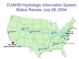
CUAHSI: Advancing Hydrologic Science through Community Engagement. Rick Hooper, President. What is hydrologic science?.

E N D
CUAHSI: Advancing Hydrologic Science through Community Engagement Rick Hooper, President
What is hydrologic science? Hydrologic science studies the occurrence, distribution, circulation and properties of water, and its interaction with a wide range of physical, chemical and biological processes, acknowledging also the added complexity of social and behavioral sciences (NRC, 1991).
Boundaries of hydrologic science • Water links atmosphere, earth, and ocean sciences • Water links living and physical world • Water is a solvent of minerals and sculptor of the landscape • Water is a key determinant of habit • Water is an economic resource and extensively engineered by humans • Hydrologic science interfaces with all these fields.
Getting the water ‘right’ • A sufficient description of the hydrologic cycle for describing water’s interaction with the physical and living world • Stores, fluxes, flowpaths, residence times • Coupling of components hydrologic cycle • Recognition of biological controls on terrestrial water cycle • Linkage to biogeochemistry, ecology, geomorphology, water resources engineering,…
Developing a Community • Disciplinary Foundations • Intellectual Basis • Rigor in Observational Science • Consensus Building • Interdisciplinary Opportunities • Enrichment from Multiple Perspectives • New Transdisciplinary Science
Community Science • Complements investigator-driven science • Articulates community goals and needs • Undertakes projects impossible for individuals • Generality of findings (cross-site comparison) • Larger scale and coherent data (top-down design) • Multidisciplinary efforts (synthesis teams) • Develops and Operates Infrastructure • Information systems • Instrumentation development and sharing
Defining the Community Agenda • Move beyond “what” hydrologists, biogeochemists, ecologists study • “How” does each discipline approach science? • How are hypotheses posed? • What constitutes “proof”? • What are valid data?
How do hydrologists work? • Hydrologic cycle as organizing principle • Quantitative approaches (e.g., budgets) • Deterministic and stochastic approaches • Both ‘bottom-up’ (fluid mechanics) and ‘top-down’ (systems) approaches • Inferential rather than empirical • Observation-limited (→ right for the wrong reason) • Multifaceted role of water (→ multiple perspectives)
Hydrologic subdisciplines • Different phenomena • Streamflow generation, contaminant transport, land surface-atmosphere interactions • …have different • Spatial scales, temporal scales, dynamics, dominant processes • …leading to disciplinary fragmentation and limited understanding among hydrologists • Bottom-up/ Top-down • Catchment, groundwater, surface water
Subdisciplines: Compound Names • Hydrometeorology, ecohydrology, geohydrology, hydropedology, biogeochemistry • Names don’t define intellectual endeavor • Names don’t define relationships among subdisciplines
Dimensions of Hydrologic Cycle • Vertical: Bedrock to Boundary Layer • Down-slope: Ridge to Stream • Down-valley: Headwater to Ocean
The Vertical Dimension • Sub-disciplines: ecohydrology, hydrometeorology, • Phenomenon: transpiration, precipitation fields, precipitation partitioning, pedogenesis • Spatial Scales: plot to continental • Temporal Scales: seconds to days
The Down-slope Dimension • Sub-disciplines: hydropedology, hillslope hydrology • Phenomenon:, streamflow generation, weathering (bioGEOchemistry), catena • Spatial Scales: 10’s to 100’s m • [Hydrologic] Temporal Scales: minutes to seasons
The Down-Valley Dimensions • Sub-disciplines: fluvial geomorphology, BIOgeochemistry • Phenomenon: flood scaling, local to regional groundwater systems, hyporheic exchange • Spatial Scales: reach/local gw systems to river basin/regional aquifer system • [Hydrologic] Temporal Scales: seconds to millennia
Towards a taxonomy • Dimensions of hydrologic cycle combine disciplines to study phenomena within a range of space and time • Encourage dialog: see where my research ‘fits’ into bigger picture • Clarify goals of subdisciplines • One approach for organizing discipline
Disciplinary Foundations • Understand epistemology of our own science • Discussed epistemology with your graduate students lately? • Explain goals to non-specialists • Achieve consensus on ‘open questions’ among subdisciplines
Observations and Observatories • The dilemma of place-based science • Extensive ‘characterization’ needed to ‘pin down’ theory • Establish generality of findings that transcend uniqueness of place • Network of Observatories with “comparable” data • Difficulty of top-down design • Emergence of CZO’s and other field sites • Virtual Network with data publication
Geomorphologist Biogeochemist Aquatic Ecologist Glaciated Valley DOC Quality? Perifluvial Oligotrophic? Carbon source? Hyporheic exchange? Backwater habitat Redox Zones? Substrate Size, Stability? Benthic Community Thalweg? Mineralogy? Chemistry? Well sorted? Abstractions in Modeling Real World “Digital Environment” DNA Sequences Water quantity and quality Meteorology Hydrologist Remote sensing Vegetation Survey Conceptual Frameworks Snowmelt Processes? Groundwater Contribution? Physical World Model Representations -Mathematical Formulae -Solution Techniques Geographically Referenced Mapping Q, Gradient, Roughness? Data Representation • Theory/Process Knowledge • Perceptions of this place • Intuition Validation Wetted Perimeter Measurements
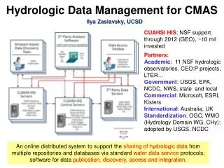
Data Integration Chesapeake Bay Program EPA USGS
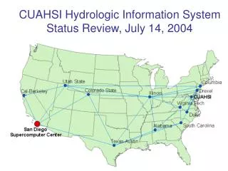
CUAHSI National Water Metadatabase • Indexes: • 20 observation networks • 1.73 million sites • 8.38 million time series NWIS STORET TCEQ
Vision: Network of “Observatories” • Access data from all sites, regardless of funding source or location • Develop larger scale context for research watersheds • Enable analysis • Across gradients • Across scale to river basin • Test generality of hypotheses in different settings • Improve predictive capacity
Realizing the Vision Global Models Regional Models Modeling Platform Dynamic Grid Data Publication Geospatial Data Publication Time Series Data Publication
Moving Forward • Data and Model Sharing • Publication of academic data • Explicit mapping of conceptual models to improve communication • Synthesis • Re-analysis of data from multiple perspectives • Pilot synthesis activities are underway
Building Communities • Pay attention to the disciplinary foundation • Need explicit definition • Taxonomy to show how subdisciplines relate • Aids in building consensus • Engage across communities • Place-based observatories as research vessels • Better communication of conceptual models • Synthesis
Summary • Collaboration to leverage existing resources • NSF investments (NEON, LTER, OOI, CZO…) • Federal Mission Agencies (USGS, USFS, ARS,…) • Partnerships • Move research scale to management scale • Limited resources, but pressing needs