Download
1 / 32
330 likes | 521 Views
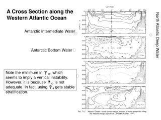
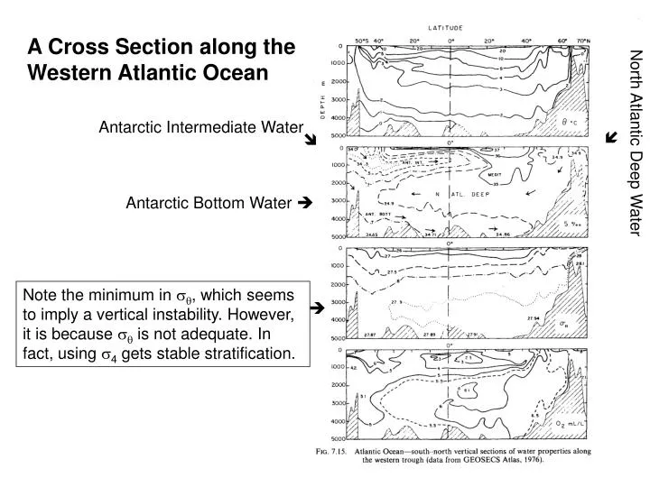
A Cross Section along the Western Atlantic Ocean. Antarctic Intermediate Water. . . North Atlantic Deep Water. Antarctic Bottom Water .

E N D
A Cross Section along the Western Atlantic Ocean Antarctic Intermediate Water North Atlantic Deep Water Antarctic Bottom Water Note the minimum in , which seems to imply a vertical instability. However, it is because is not adequate. In fact, using 4 gets stable stratification.
The Sources of the North Atlantic Deep Water The next densest water is the North Atlantic Deep Water (NADW, Temperature 2.5oC, salinity 35.03). NADW fills the depth range between 1000 m and 4000 m. In vertical sections, it is seen as a layer of relatively high salinity (>34.9) and oxygen (above 5.5ml/L) extending southward from the Labrador Sea to the Antarctic Divergence. More detailed inspection reveals two oxygen maxima within the NADW in the subtropics, at 2000-3000 m and 3500-4000 m depth, indicating the existence of two distinct Deep Water varieties. In fact, there is also a third branch. The three branches are called as the lower, middle, and higher NADW, which show slight density differences and remain vertically layered along their southward paths.
Major Parts of the North Atlantic Deep Water are formed in the Greenland and Norwegian Seas as well as the Labrador Sea.
Greenland Sea and Norwegian Sea: The lower NADW The NADW is mainly formed in the Greenland Sea and the Norwegian Sea (80%). A submarine ridge extending from Greenland to Scotland limits the water exchange between the North Atlantic Ocean and the Norwegian Sea. In the Greenland Sea, relatively light incoming water from the North Atlantic becomes denser by strong local winter cooling and sinks (the open ocean process, different from the shelf water in the Antarctic). The sinking is associated with the passage of storm systems, each event lasting less than a week. The Greenland Sea Deep Water is combined with the waters from the Arctic shelf region to form the Arctic Bottom Water. The Norwegian Sea is the mixing basin where Arctic Bottom Water obtain its final characteristics (potential temperature is close to -0.95oC and Salinity 34.9). The dense Arctic Bottom Water flows into the North Atlantic over the ridge connecting Greenland and British isles.
Open Ocean Sinking A background cyclone gyre circulation in response to winds raise a dome of isotherm (scale~100km) Density increase in the upper ocean due to surface cooling to form the preconditioning pool Mixed layer penetration into the intermediate water dome Narrow plumes with width on the order of 1km develop, with downward speed as high as 10 cm/s Vertical homogeneous fluid forms Horizontal spreading of the deep water
The Faroe Bank Channel is about 800 m, outflow roughly 1x10⁶ m3/s (1 Sv). The second channel passes over the ridge between the Faroe Islands and Iceland (sill depth 300-400 m, transport 1 Sv). The combined Iceland-Scotland overflow, after leaving the ridge is about 5 Sv (3 Sv is entrained Atlantic water). This overflow continues southward against the eastern side of the Mid-Atlantic Ridge, and passes through the Gibbs Fracture Zone near 53oN into the Labrador Basin. Its westward transport is still 5 x 10⁶ m3/s (little direct flow into low latitudes). This current then flows northward in the eastern Labrador basin, and, south of Greenland, joins the third flow from the Denmark Strait (about 600 m).
The total transport is 10x106 m3/s for the full flow south of Greenland, thereby indicating a contribution of 5x10⁶ m3/s from the Denmark Strait overflow. Part of it is Atlantic water entrained by the Denmark Strait overflow as it descends the Greenland continental slope. Even though the overflows on either side of Iceland originate from the same Norwegian Sea water, the Denmark Strait overflow is distinctly colder and fresher (=0.0-0.2oC, S=34.88-34.93) than Iceland-Scotland overflow (=1.8-3oC, S=34.98-35.03), mainly because the upper kilometer Atlantic water entrained in the east is warmer and more saline. The overflow is highly variable. Measurements show that overflow is coming in bursts 1-2 day long, with speeds up to 140 cm/s, separated by 1 to several days. It probably reflects the fact the overflow is generated by cyclonic winds from intense storm systems that lift up the bottom water by a hundred meters or so behind the sill. The lower NADW has its origin in the Greenland-Iceland-Scotland overflow region, which indicates that some Deep Water is formed before the Arctic Bottom Water reaches the Labrador Sea through mixing of the overflow water with the surrounding waters. East of the Mid-Atlantic Ridge, this is the only mechanism for the formation of Deep Water and the lower NADW is particularly prominent in the eastern basins. Therefore, it is also called as the eastern NADW.
Labrador Sea: Middle NADW For a long time, the origin of the NADW was thought to be in the Labrador and Irminger Seas off the southern tip of the Greenland where winter cooling of relatively saline water was considered to cause it to sink to considerable depths and then spread southward. Now it is generally recognized that the NADW is mainly produced in the Greenland and Norwegian Seas. However, sinking in the Labrador Sea is still a major source of the formation of NADW. In the region south of the southern tip of Greenland, the water properties in late winter are almost uniform from the surface to near bottom. The explanation for this situation was that the deep water was actually forming at the time. This Labrador Sea Water is the product of deep convection during the winter months. However, the deep convection is not an annual event. Estimates are that they occur in 6 out of 10 years. Moreover, no “event” of large-scale convective overturn was observed yet. The processes causing the convection in this region are not clear, probably through small space and time scales. The middle (or western) NADW can be traced back to the surface near 55oN, which reflects the fact that it is formed by mixing the Arctic Bottom Water with the deep water produced in the Labrador Sea. The transport is estimated to be 3.5x10⁶ m3/s.
From this column of the Labrador Sea, a tongue of 3o to 3.25oC water extended south at depths of 2000 to 2500 m. This water had a high oxygen content; even at 2000 m depth it was still 90% of that at the surface.
Mediterranean Sea: Upper NADW The rate of outflow through the Straits of Gilbratar is estimated from the overall salt budget for the Mediterranean Sea and current measurements; both agree on a mean of about 1x10⁶ m3/s. The Mediterranean Water Mass (MW) leaves the Strait of Gilbratar with T=13.5oC and S=37.8. Within 250km its T & S are reduced by mixing to 11o-12oC and 36-26.2. By the time the outflow current completes its descent and departs from the continental slope, its volume transport has increased, by entrainment of Atlantic water, to roughly 10x106 m3/s.
The Smax marking the core of the Mediterranean outflow (named as the Upper NADW by Wüst) is found at about 1200 m in the southeastern North Atlantic. (Relatively high salinities can be detected at least as deep as 3000m.) The MW spreads isopycnally across the ocean, mixing gradually with the Deep Water below. Relative to the other NADW it has higher T & S maximized at 1000m depth near the upper limit of the NADW. MW first flows northward under the influence of the Coriolis force and mixes into the subtropical gyre circulation, eventually spreading southward and westward. The T-S core sinks as the water spreads.
Eddies in the Mediterranean Water The spreading of the Mediterranean Water is not smooth. Instead, it is injected into the NADW in the form of subsurface eddies containing a high proportion of Mediterranean Water in its core, referred to as “meddies”. Meddies limit local mixing and keep the core together over large distance, as far as in the Sargasso Sea. The salinity and temperature anomalies found in the long-term average distribution have to be seen as the result of a process in which many such meddies travel through the upper NADW range at any particular moment in time, slowly releasing their load of extra salt and heat into the surrounding Deep Water.
The Track of the North Atlantic Deep Water Both are more saline at their sources than the ABW, and their salinities are increased somewhat in mid-latitudes of the North Atlantic through mixing with the outflow from the Mediterranean Sea. Although the lower and middle NADW are made dense by cooling, their temperatures are not reduced to freezing point before sinking, but remain high enough that, despite more saline, they are less dense than the Antarctic Bottom Water, and therefore override it. This high-salinity water spreads throughout the South Atlantic, is carried eastward around Antarctica in the Circumpolar Current, and its elevated salinities can be followed into low latitudes of the South Indian and South Pacific Oceans.
Other Major Water Masses Antarctic Circumpolar Water (CPW) Below the surface and extending to the bottom at depths to 4000m. Maximum temperature is 1.5-2.5oC at 300-600m and then decreases to between 0o-0.5oC near the bottom. Salinity 34.7psu. Carried around by Antarctic Circumpolar Current (ACC) and found all around the continent at about the same depth (CPW is probably a mixture of Antarctic Bottom Water and the North Atlantic Deep Water). Antarctic Intermediate Water (AIW) Formed by the sinking of the Antarctic surface water, mostly from convection east of southern Chile and west of southern Argentina. It is also suggested that the AIW formation occurs circumpolarly by cross-polar-front mixing between low-salinity surface water and subantarctic surface water. AIW is quite homogeneous (T=2o-3oC, S=34.2) and has density t=27.4 higher than the water further north. It spreads into all oceans with the Circumpolar Current and continues northward below the surface. It has a thickness of 500 m and forms a tongue of relatively low salinity water with core at 800 to 1000 m at 40oS. AIW mixes with more saline water from above and below during northward movement. (Intermediate Water may also be formed n the northern hemisphere by convection or subduction.)
A series of TS-diagrams from the Atlantic Ocean, from 40°S to 40°N, showing the erosion of the salinity minimum associated with Antarctic Intermediate Water along the path of the water mass. The red line traces the salinity minimum produced by the relatively fresh Antarctic Intermediate Water. Color indicates oxygen content. Note how the oxygen content associated with the salinity minimum decreases from south to north, indicating the aging of the Antarctic Intermediate Water. (based on OceanAtlas of J. Osborne, J. Swift and E. P. Flinchem) From M. Tomczak: Introduction to Physical Oceanography http://gaea.es.flinders.edu.au/~mattom/IntroOc/lecture07.html
Sketch of the water mass distribution in the world ocean AABW: Antarctic Bottom Water, CPW: Circumpolar Water, NADW: North Atlantic Deep Water, PDW: Pacific Deep Water, AAIW: Antarctic Intermediate Water, AIW: Arctic Intermediate Water, MedW: Mediterranean Water, RedSW: Red Sea Water, gold: Central Water, brown: surface water. From M. Tomczak: Introduction to Physical Oceanography http://gaea.es.flinders.edu.au/~mattom/IntroOc/lecture07.html
Pacific Deep Water Uniform property in 2000-3000 m Old water type (about 1000 years) A mixture of AABS and AAIW No deep water formation in the North Pacific
Great Ocean Conveyer Belt (Broecker 1991) This paradigm emphasizes the role of North Atlantic Deep Water cell as well as the Indonesian through flow in the global scale of the overturning, but completely misses the Antarctic Bottom Water cell.
Abyssal Circulation Deep ocean is below the permanent thermocline (at 1~km) with ~2o-4oC below 2 km (0o-2oC at 4 km typically). Waters of such low temperatures can only be formed by cooling in Polar Regions. In both Polar Regions the zones of sinking are quite narrow, and the convective sinking itself is difficult to observe directly. The sinking instead is largely inferred from the distribution of ocean properties such as temperature, salinity, and especially oxygen. The deep water from the major sources is between 10-20 Sv, with a considerable fraction estimated to be water entrained during the sinking as well as entrained laterally as the source water into the deep ocean. The presence at other latitudes of such cold water implies a large scale deep circulation, the abyssal circulation, which carries the cold water formed in Polar Regions to fill the rest of the deep ocean basins. The water must eventually rise to the surface and, heated to the observed surface temperatures, must then flow poleward to replace the water which has sunk to the bottom, forming an endless global cell of motion.
Dynamical Constraint of the Deep Circulation A conceptual framework of the abyssal circulation was developed by Stommel (1958) and Stommel and Arons (1960a,b), which explains dynamically the horizontal structure of the vertically averaged abyssal circulation, especially its western boundary currents. The theory is actually a straightforward application of the Sverdrup theory. • Assumptions: • In compensation for the known sinking of the near surface water in small regions, there is a general slow upward movement of deep water over most of the rest of the ocean. • The mean horizontal deep flow in the open ocean is strictly geostrophic, in the sense that the streamlines parallel isobars, and their speeds inversely proportional to their spacing and to the sine of the latitude.
From assumption (1) The slow global upward advection of cold water from abyss balances the downward diffusion of heat from the upper layer at the bottom of the main thermocline: or where is the upwelling velocity of the abyssal water at the base of thermocline is the downward heat flux. This leads to an estimate of vertical velocity at the base of the thermocline as: where d is the vertical scale of variations of the heat flux. On the other hand, since the overall area of the world oceans is toughly , to obtain a flux of 20 Sv from the abyss to the thermocline to replace the waters sinking into the abyss in the Polar Regions, an independent estimate of the upwelling is For a vertical scale d of the order of 1 km, this would suggest ~0.66 cm2/s. This is larger than direct measurement of 0.11 cm2/s (Ledwell et al., 1993). (The estimate of transport (20 Sv) may be too high)
From assumption (2) The geostrophic vorticity balance within the deep ocean then is • Integrating the vorticity equation vertically from the ocean bottom to the “top” of the deep water, we have where is the total meridional transport of the abyssal circulation. • wB is the vertical velocity at the bottom. If we take the floor of the ocean to be level in the large scale mean, wB is zero. Then we have the “Sverdrup” relation in the seep ocean Since w∞ is everywhere positive except for the very limited areas in the polar regions, V>0 in the northern hemisphere and V<0 in the southern hemisphere. The interior transport is toward the sources. A western boundary is required to close the mass balance.
Stommel, Arons and Faller Experiment
Stommel-Arons Theory: Abyssal Flow on a Sphere in spherical coordinates, considera latitudinal bounded two-layer ocean. Local sinking S0 is specified at pole from the upper to lower layer. The return flow has a vertical velocity wo, specified over the area of the ocean basin at the top of the abyssal layer. For the layer representing the abyss, the motion is geostrophic. , where R is radius of the earth and and are longitude and latitude. The continuity equator is .
Combining the geostrophic and continuity equations, we derive the Sverdrup vorticity equation with and Integrating vertically over the depth H yields: or • v is always poleward as long as wo is positive. • v must vanish at the equator. • Cross equatorial flow must be in regions where the Sverdrup balance is broken (i.e., the western boundary). From , we have and Assume wo is independent of horizontal position (constant), we have .
Consider an ocean basin from the equator to the pole. For an arbitrary latitude , the sum of the interior flux (TI) and the western boundary current’s transport (Tw) through an arbitrary latitude is balanced by the source’s contribution So and flux out of the abyss through the interface to the north of (Tout). i.e., Since . If the mass is balanced over the northern hemisphere In this case,
Discussion of the results: • The western boundary layer transport is southward for all ≥0. • The boundary transport is exactly twice the source strength at the pole since the boundary current must carry southward the fluid issuing from the source as well as all of the impinging interior flow. • The interior flow comprises a basinwide recirculation and has a northward mass flux at the apex equal to the source strength. • Half the mass flux of the boundary layer comes from the source and half from the recirculating interior flow. • The interior is fed from the western boundary current as the current flows southward, which falls to zero as it approaches the equator. During the southward movement, the western boundary current loses a total mass flux equal to 2So. • One half of this flow is recirculated in the interior and ends up at the apex to return through the western boundary current. • The other half is lost through the interface to the thermocline and is directly replaced in the western boundary layer at the apex by the source.