Download
1 / 1
10 likes | 107 Views
Philip J. Klotzbach and William M. Gray Colorado State University, Fort Collins, Colorado. United States Landfalling Hurricane Webpage Application. Abstract

E N D
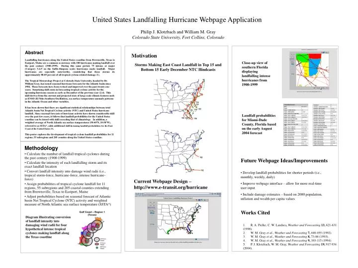
Philip J. Klotzbach and William M. Gray Colorado State University, Fort Collins, Colorado United States Landfalling Hurricane Webpage Application Abstract Landfalling hurricanes along the United States coastline from Brownsville, Texas to Eastport, Maine are a common occurrence with 188 hurricanes making landfall over the past century (1900-1999). During this same period, 73 intense or major (Category 3-4-5 on the Saffir-Simpson scale) hurricanes made landfall. Major hurricanes are especially noteworthy, considering that these storms do approximately 80-85 percent of all tropical cyclone-related damage (1). The Tropical Meteorology Project at Colorado State University, headed by Dr. William Gray, has issued seasonal hurricane forecasts for the Atlantic basin since 1984. These forecasts have been revised and improved over the past twenty-one years. Surprising skill exists in forecasting tropical cyclone activity for the upcoming hurricane season as early as December of the previous year (2-4). This skill derives from the current and projected state of large-scale climate features such as ENSO (El Niño-Southern Oscillation), sea surface temperature anomaly patterns in the Atlantic Ocean and other variables. It has been shown that there are significant statistical relationships between total Atlantic basin Net Tropical Cyclone activity (NTC) and United States hurricane landfall. Since seasonal forecasts of hurricane activity have shown considerable skill over the past few years, it follows that landfall probabilities for the United States coastline can be issued with skill exceeding that of climatology. In addition, a weighted average of North Atlantic sea surface temperatures (50-60ºN, 10-50ºW), referred to as SSTA*, adds additionalskill in issuing landfall probabilities for the East Coast of the United States (5). This poster explores the development of tropical cyclone landfall probabilities for 11 regions, 55 subregions and 205 counties along the United States coastline. Motivation Storms Making East Coast Landfall in Top 15 and Bottom 15 Early December NTC Hindcasts Close-up view of southern Florida displaying landfalling intense hurricanes from 1900-1999 Landfall probabilities for Miami-Dade County, Florida based on the early August 2004 forecast • Methodology • Calculate the number of landfall tropical cyclones during the past century (1900-1999) • Calculate the intensity of each landfalling storm and its exact landfall location • Convert landfall intensity into damage wind radii (i.e., tropical storm-force, hurricane-force, intense hurricane-force) • Assign probabilities of tropical cyclone landfall for 11 regions, 55 subregions and 205 coastal counties extending from Brownsville, Texas to Eastport, Maine • Adjust probabilities based on seasonal forecast of Atlantic basin Net Tropical Cyclone (NTC) activity and weighted measure of North Atlantic sea surface temperature (SSTA*) Future Webpage Ideas/Improvements • Develop landfall probabilities for shorter periods (i.e., monthly, weekly, daily) • Improve webpage interface – allow for more real-time user input • Include damage estimates – based on 2000 population, inflation and wealth per capita values Current Webpage Design – http://www.e-transit.org/hurricane Works Cited Diagram illustrating conversion of landfall intensity into damaging wind radii for four hypothetical intense tropical cyclones making landfall along the Texas coastline 1. R. A. Pielke, C. W. Landsea, Weather and Forecasting 13, 621-631 (1998). 2. W. M. Gray et al., Weather and Forecasting 7, 440-455 (1992). 3. W. M. Gray et al., Weather and Forecasting 8, 73-86 (1993). 4. W. M. Gray et al., Weather and Forecasting 9, 103-115 (1994). 5. P. J. Klotzbach, W. M. Gray, Weather and Forecasting 19, 917-934 (2004).