Download
1 / 21
210 likes | 338 Views
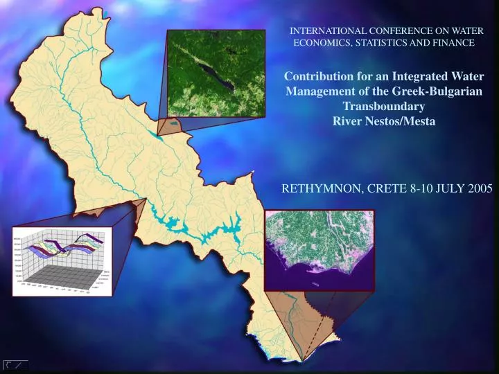
INTERNATIONAL CONFERENCE ON WATER ECONOMICS, STATISTICS AND FINANCE Contribution for an Integrated Water Management of the Greek-Bulgarian Transboundary River Nestos/Mesta RETHYMNON, CRETE 8-10 JULY 2005.

E N D
INTERNATIONAL CONFERENCE ON WATER ECONOMICS, STATISTICS AND FINANCE Contribution for an Integrated Water Management of the Greek-Bulgarian Transboundary River Nestos/Mesta RETHYMNON, CRETE 8-10 JULY 2005
INTERNATIONAL CONFERENCE ON WATER ECONOMICS, STATISTICS AND FINANCERETHYMNON, CRETE, GREECE 8-10 JULY 2005 “CONTRIBUTION FOR AN INTEGRATED WATER MANAGEMENT OF THE GREEK BULGARIAN TRANSBOUNDARY RIVER NESTOS/MESTA ” by T. MIMIDESa, N. KOTSOVINOSb, P. KARAKATSOULISa, S. RHIZOSa, C. SOULISa & D. STAVROPOULOSa a: AGRICULTURAL UNIVERSITY OF ATHENS, FACULTY OF NATURAL RESOURCES AND AGRICULTURAL ENGINEERING, LABORATORY OF AGRICULTURAL HYDRAULICS,IERA ODOS 75, VOTANIKOS KIPOS, ATHENS, 118 55, GREECE. b: DEMOCRITUS UNIVERSITY OF THRACE, SCHOOL OF ENGINEERING, DEPARTMENT OF CIVIL ENGINEERING, LABORATORY A’ HYDRAULIC AND HYDRAULIC WORKS, B. SOFIAS 12, 67 100 XANTHI, GREECE.
INTERNATIONAL CONFERENCE ON WATER ECONOMICS, STATISTICS AND FINANCERETHYMNON, CRETE, GREECE 8-10 JULY 2005 • The purposes of this study • The transboundary river Nestos/Mesta has always been the objective of many meetings between Greek and Bulgarian experts . • A critical point of these discussions was the determination of the appropriate quantity of the annual water volume that the upstream country Bulgaria , should provide to Greece for ecological purposes and for urban and agricultural exploitation. • The integrated study of the hydrological basin of Nestos/Mesta river could have solved this problem, however, such a study was not made in the past, mainly because Bulgaria’ old regime practically did not allowed information or publication of the rainfall measurements at Nestos/Mesta river.
INTERNATIONAL CONFERENCE ON WATER ECONOMICS, STATISTICS AND FINANCERETHYMNON, CRETE, GREECE 8-10 JULY 2005 • The purposes of this study • The basic purpose of this work was to present for the first time useful meteorological data from both countries and to contribute towards an integrated study of the rainfall and runoff of the whole hydrological basin, in agreement with directive EU 2000/60. This was accomplished within an INTERREG II project (Greece-Bulgaria) . • In this particular paper combined information was provided for the first time from Bulgarian authorities to calculate the natural discharge of Mesta/Nestos river at the border and the outflow discharge at Aegean Sea. • Most important, for the first time the isohyetal map for the whole hydrological basin was produced, a map which is necessary for the agricultural exploitation of the basin and for ecological purposes.
INTERNATIONAL CONFERENCE ON WATER ECONOMICS, STATISTICS AND FINANCERETHYMNON, CRETE, GREECE 8-10 JULY 2005 • Integrated rainfall analysis • In this study data from 16 precipitation gauges in the Greek territory of the Nestos/Mesta basin were analysed ( density of precipitation gauge 2525 /16=145 Κm2/station) and data from 30 precipitation gauges in the Bulgarian territory (density of precipitation gauge 3437/30=115 Κm2/station ). • The density of the precipitation stations is satisfactory for both the Greek and Bulgarian regions and permits the integrated understanding of the hydrological features of the basin. The mean annual rainfall was calculated at 36 meteorological stations of both countries, for which precipitation data are available for the years 1965-1996 . • The mean annual precipitation height varies from 1004 mm at Kechrokampos (Greece) to 545 mm at Xrysoupoli . The maximum annual precipitation was equal to 1656 mm and it was observed at Kechrokampos the year 1979 . The minimum annual precipitation was equal to 216 mm and it was observed at Xrysoupoli the Year 1989 . • The ratio of the maximum annual precipitation to minimum annual precipitation varied from 4.27 at station Prasinada to 1.7 at station Jakorouda leeve . • All the above observations can be seen in Table 1.
INTERNATIONAL CONFERENCE ON WATER ECONOMICS, STATISTICS AND FINANCERETHYMNON, CRETE, GREECE 8-10 JULY 2005 Table 1. SORTING IN DESCENDING ORDER OF MEAN ANNUAL VALUES AT 36 RAINFALL STATIONS IN GREECE AND IN BULGARIA FOR 30 YEARS (1965-1995)
INTERNATIONAL CONFERENCE ON WATER ECONOMICS, STATISTICS AND FINANCERETHYMNON, CRETE, GREECE 8-10 JULY 2005 • Correlation analyses • The correlation of the annual runoff at various stations in the whole basin was analyzed. • The results are presented in Figure 2 , from where we get an insight into the pattern of the rainfall in the basin . • In general , a good correlation of the annual precipitation of the stations in the Greek territory can be observed. • The correlation of the Greek stations with the Bulgarian stations close to the border (e.g. Balkosel , Dospat, Goze Delchev) is in general reasonable , but it is interesting to note that the correlation with Razlog is negative. Figure 2. Correlation coefficients of the annual runoff at various stations
INTERNATIONAL CONFERENCE ON WATER ECONOMICS, STATISTICS AND FINANCERETHYMNON, CRETE, GREECE 8-10 JULY 2005 • Analysis of time variation of annual precipitation • The moving average of the time series of annual precipitation indicate a systematic fluctuation of the annual precipitation with period of 5±2 years. Two Bulgarian stations (Razlog and Goze Delchev ) have reliable precipitation data from the Year 1914 up to 1995 . • There is a periodic trend of about 20 years in the appearance of wet periods ,i.e. a local maximum the years 1939, 1959 and 1979. Also, the trend in recent years is the increase of the annual precipitation at the station Goze Delchev and Osenovo (see Figure 3 and 4). • A similar trend is indicated at the annual precipitation data at the Greek stations of Volakas, Leivaditis ,Kechrokampos , Likodromio, Prasinada, Ptelea, Stegno, Axladia, and Xrysoupoli, i.e. a wet period is identified the Year 1979 , then a second wet period is around 1989 . • However it seems that after the Year 1993 the annual precipitation is increasing . Dry periods are identified the years 1950, 1970 and 1990. While portions of precipitation record may suggest an increasing or decreasing trend, there is usually a tendency to return to the mean, abnormally wet periods tend to be balanced by dry periods.
INTERNATIONAL CONFERENCE ON WATER ECONOMICS, STATISTICS AND FINANCERETHYMNON, CRETE, GREECE 8-10 JULY 2005 Figure 4. Moving average of the annual precipitationat the station Osevono (61530). We observe the periodic (about 20 years) fluctuation. Figure 3. Moving average of the annual precipitationat the station Goze Delchev (61120). We observe the periodic (about 20 years) fluctuation.
INTERNATIONAL CONFERENCE ON WATER ECONOMICS, STATISTICS AND FINANCERETHYMNON, CRETE, GREECE 8-10 JULY 2005 • Water Balance – monthly and mean annual runoff • The discharge is measured at various sites in the hydrological basin. The annual flow in Bulgaria was obtained at several gauging stations. Using the measurements of discharge at various stations in Greece and Bulgaria, an empirical relationship was found between the mean annual runoff in mm and the mean altitude of the catchments area (see Figure 5). Figure 5. Correlation of the mean annual runoff (in mm) with the mean altitude of the catchmentsarea of the station. The data labels (numbers) are the station numbers at the Bulgaria catchments area.
INTERNATIONAL CONFERENCE ON WATER ECONOMICS, STATISTICS AND FINANCERETHYMNON, CRETE, GREECE 8-10 JULY 2005 • The water budget • The water budget can be used to estimate the runoff from a watershed. Difficulty with the method is the usual lack of satisfactory data to quantify the various components properly. A hydrologic budget equation for the earth’ s surface runoff (WS) can be written: WS=P-(WE+WG) Where: • WS= surface runoff • P= precipitation • WG= infiltration (groundwater runoff ) •WE= evapotranspiration
INTERNATIONAL CONFERENCE ON WATER ECONOMICS, STATISTICS AND FINANCERETHYMNON, CRETE, GREECE 8-10 JULY 2005 • Measurements and results • The mean precipitation for the basin between Papades (close to Greek border) and Temenos (for hydrological years 65-66 to 95-96 ) is 790 mm. The annual runoff from the basin between Papades and Temenos (area 1115 km2) is about 387 x106 m3, with an annual runoff depth of 347 mm . Therefore the average annual runoff coefficient for the basin Papades-Temenos is 347/790=0.44. • The mean precipitation for the whole basin (based on data from 1965 to 1995) is about 807 mm and the uncorrected mean precipitation for the basin up to Temenos is 830 mm. The natural average runoff at Temenos is 1868 x106 m3 and the area of the basin up to Temenos (including Dospat ) is 4921 km2. The average runoff for the whole basin up to Temenos 379.6 mm. Therefore the annual, average runoff coefficient for the whole basin up to Temenos is 379.6/830=0.46. • This value is larger than the runoff coefficient 0.438 calculated in the Bulgarian territory and from the runoff coefficient 0.44 calculated for the sub basin Papades -Temenos. • The average physical runoff from the Rila mountain up to the Nestos estuary was found 2092 x106 m3 and the average discharge about 66.4 m3/s , based on data from the Hydrological years 1965-1966 to 1989-1990.
INTERNATIONAL CONFERENCE ON WATER ECONOMICS, STATISTICS AND FINANCERETHYMNON, CRETE, GREECE 8-10 JULY 2005 • Observations • The difference between the natural river flow at Temenos and the actual runoff which has been measured is about 505 x106 m3. The Bulgarian partner estimates that 350 x106 m3 are retained for various uses in Bulgaria. Therefore there is a mean annual loss of water of 150 x106 m3 of undermined origin . The water balance is presented in Figures 6, 7 and 8 . • The measured annual values of the runoff at various downstream stations is given in Fig. 9, from where the fluctuation between humid and dry years is observed.
INTERNATIONAL CONFERENCE ON WATER ECONOMICS, STATISTICS AND FINANCERETHYMNON, CRETE, GREECE 8-10 JULY 2005 Figure 6, The natural annual runoff that enters Greece from Mesta and Dospat Figure 7. Natural annual runoff of Nestos/Mesta river in the Greek territory for the period 1965-1995 (natural runoff from Bulgaria for this period = 1324 million m3.
INTERNATIONAL CONFERENCE ON WATER ECONOMICS, STATISTICS AND FINANCERETHYMNON, CRETE, GREECE 8-10 JULY 2005 Figure 8. Natural mean annual runoff Mesta/Nestos river in the Greek territory for the period 1965-1995 compared to measured runoff (mean annual natural runoff from Bulgariafor this period is taken equal to 1324 million cubic meters).
Figure 9. Measured annual runoff of Mesta/Nestos river in the Greek territory of the period 1965 – 1995.
INTERNATIONAL CONFERENCE ON WATER ECONOMICS, STATISTICS AND FINANCERETHYMNON, CRETE, GREECE 8-10 JULY 2005 • Conclusions • For the first time the isohyetal map for the whole hydrological basin , a map which is necessary for the agricultural exploitation of the basin and for ecological purposes was produced. • Also, an analysis of the moving average of the time series of annual precipitation at various stations indicates a systematic fluctuation of the annual precipitation with period of 5±2 years. A periodic trend of about 20 years in the appearance of wet periods was found and the trend in recent years (after 1993) in the increase of the annual precipitation was observed. • Dry periods were identified the years 1950, 1970 and 1990. • While portions of precipitation record may suggest an increasing or decreasing trend, there is usually a tendency to return to the mean, abnormally wet periods tend to be balanced by dry periods. • Besides, a study of the annual flow discharges indicate that the annual average runoff coefficient for the whole basin was about 0.438 .
INTERNATIONAL CONFERENCE ON WATER ECONOMICS, STATISTICS AND FINANCERETHYMNON, CRETE, GREECE 8-10 JULY 2005 • Conclusions • Finally, a number of useful thematic maps anddiagrams was produced ( e.g., isohyetal map, runoff coefficients, natural runoff etc), whichsubsequently will help the integrated management of the river for improving the planning ofenergy production from large or small dams ( e.g. Bulgaria has a few small hydro plants and Greecehas two large dams at Thisavros-Platanovrysi), for planning new agricultural developments that will not disturb the ecological balance of the river by providing the appropriate ecological discharge,for leisure activities along the river (e.g. kayak) . • All these activities require a good knowledge ofthe integrated hydrology of the river, and this paper contributes in advancing this pool ofinformations.