Download
1 / 36
360 likes | 561 Views
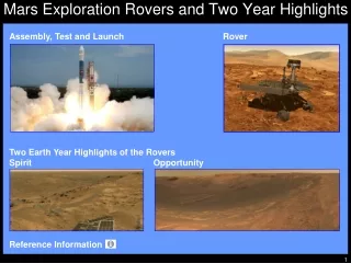
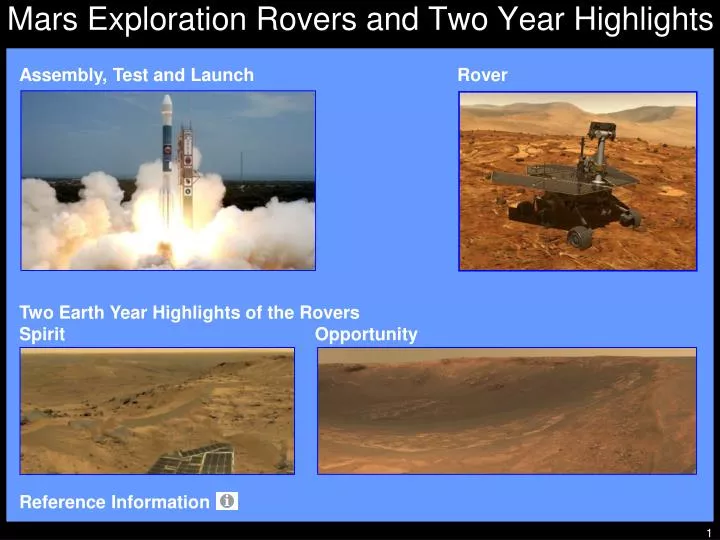
http://mars.jpl.nasa.gov/mer/gallery/artwork/rover2browse.html. Mars Exploration Rovers and Two Year Highlights. Assembly, Test and Launch. Rover . Two Earth Year Highlights of the Rovers Spirit Opportunity . Reference Information .

E N D
http://mars.jpl.nasa.gov/mer/gallery/artwork/rover2browse.htmlhttp://mars.jpl.nasa.gov/mer/gallery/artwork/rover2browse.html Mars Exploration Rovers and Two Year Highlights Assembly, Test and Launch Rover Two Earth Year Highlights of the Rovers Spirit Opportunity Reference Information http://marsrovers.jpl.nasa.gov/gallery/press/opportunity/20040506a/01-SS-01-Endurance-B101R1_br2.jpg
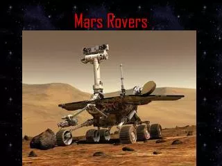
MER and Mars Pathfinder Rovers at JPL Spirit and Opportunity during assembly and test at the Jet Propulsion Laboratory shown with the Mars Pathfinder engineering model rover (first to operate on Mars in July 1997). Mars Pathfinder Sojourner Engineering Rover Model Opportunity Spirit
MER-A spacecraft atop the Delta II launch vehicle at Space Launch Complex 17-A, Cape Canaveral, FL. MER-A Spacecraft/Spirit Rover Stack-up Payload Fairing Half MER-A Spacecraft with Spirit Rover in Aeroshell Stage III Stage II
MER-A/Spirit Rover Launch MER-A spacecraft launched by the Delta II 7925 at Pad 17-A, Cape Canaveral, FL on June 10, 2003.
MER-B/Opportunity Rover Launch MER-B spacecraft launched by the Delta II 7925H at Pad 17-B, Cape Canaveral, FL on July 7, 2003.
First Look from Spirit on Mars January 3, 2004 -Spirit lands on Mars January 4, 2004 - This mosaic image taken by the navigation camera on Spirit shows a panoramic view of the rover on the surface of Mars in Gusev Crater. The crater is about 93 miles in diameter. A surface depression nicknamed “Sleepy Hollow” can be seen to the left of center. It is an impact crater 30 feet across and located about 40 feet north of Spirit. The airbags, shown on the far right and left, failed to fully deflate postponing Spirit’s egress off the landing craft. The rover turns on the lander and drives down one of the other lander ramps onto the Martian surface on January 15. http://marsrovers.jpl.nasa.gov/gallery/press/spirit/20040104a/PIA04980.jpg
Spirit Observes Bonneville Crater and Columbia Hills March 12 and 13, 2004 - This mosaic is an approximate true color image from Spirit’s panoramic camera showing “Bonneville” Crater andthe rover's next destination named the “Columbia Hills,” seen in the upper right. The crater is about 650 feet in diameter and about 90 feet deep.After two months of travel to Bonneville, the impact crater was a big disappointment. There are no layered rocks, it is shallow, filled with sand and dust, the walls are lined with the same shattered basalt seen previously in Gusev Crater and no evidence of sediment below the basalt. http://marsrovers.jpl.nasa.gov/gallery/press/spirit/20040318a/07-JG-01-pan-A074R1_br2.jpg
Spirit Observes Earth NASA/JPL-Caltech/Cornell/TexasA&M March 13, 2004 - This is the first image ever taken of Earth from the surface of a planet beyond the Moon. Spirit took the image one hour before sunrise on the 63rd Martian day of its mission. The image is a mosaic of images taken by the rover's navigation camera showing a broad view of the sky, and an image taken by the rover's panoramic camera of Earth. http://www.space.com/bestimg/index.php?guid=41dd96ca88256&cat=rover
http://www-b.jpl.nasa.gov/images/mer/2004-06-15/04-LS-01-Pot-med.jpghttp://www-b.jpl.nasa.gov/images/mer/2004-06-15/04-LS-01-Pot-med.jpg Spirit Finds First Evidence of Water at Gusev June 13, 2004 - This false-color image taken by the Spirit panoramic camera shows the rock dubbed “Pot of Gold” (upper center), located near the base of the “Columbia Hills” in Gusev Crater. The rock is about the size of a softball. The insides of the rocks appear to have been eroded, while their outer rinds remain in tact. These outer rinds are reminiscent of those found on rocks at Meridiani Planum's “Eagle Crater” by Opportunity. June 25, 2004 - This 1.2 inches by 1.2 inches close-up image taken by Spirit highlights the nodular nuggets that cover the rock “Pot of Gold.” These features appear to stand on the end of stalk-like projections. Data from the rover's scientific instruments has shown the “Pot of Gold” contains the mineral hematite. Hematite, found on Earth, can be formed in three different ways: in standing water; in small amounts of hot fluids (hydrothermal processes); and in volcanic rock. http://marsrovers.jpl.nasa.gov/gallery/press/spirit/20040625a/03-SS-03-MI3-A170R1_br.jpg
Spirit Perched Above Gusev Crater Gusev Crater Rim August 5, 2004 - This approximate true-color image taken by Spirit shows a rock outcrop dubbed “Longhorn,” and behind it, the sweeping plains of Gusev Crater. On the horizon, the rim of Gusev Crater is clearly visible. The view is to the south of the rover. The Longhorn outcrop measures about 18 feet wide and 5 feet high. http://marsrovers.jpl.nasa.gov/gallery/press/spirit/20040818a/01-SSS-01-Mosaic-A223R1.jpg
Spirit Finds Evidence Water Flowed Through Rock August 13, 2004 - This approximate true-color image taken by the Spirit panoramic camera shows the rock outcrop dubbed “Clovis” about 30 feet above the plains of Gusev Crater. The rock was softer than other rocks studied so far at Gusev. The rover easily ground a hole into Clovis with its rock abrasion tool. Analysis of the interior of the hole with the rover's scientific instruments found higher concentrations of sulfur, bromine and chlorine compared to basaltic (volcanic) rocks at Gusev. This might indicate that Clovis was chemically altered, and that fluids once flowed through the rock depositing these elements. This suggests that water may once have been active at Gusev. http://marsrovers.jpl.nasa.gov/gallery/press/spirit/20040818a/03-DM-02-Clovis2-A223R1.jpg
Spirit Views Husband Hill Summit Destination February 27 to March 2, 2005 – Spirit’s panoramic camera acquired this view from a position known as “Larry's Lookout” along the drive up “Husband Hill.” The summit of Husband Hill is the far peak near the center, and it is about 656 feet from the rover and about 148 feet higher in elevation. The bright rocky outcrop near the center of the panorama is part of the “Cumberland Ridge.” Beyond to the left is the “Tennessee Valley.” Spirit's tracks leading back from the “West Spur” region can be seen on the right side of the panorama. The region just beyond the area where the tracks made their “zig-zag” is the area known as “Paso Robles,” where Spirit discovered rock and soil deposits with very high sulfur abundances. After obtaining this mosaic, Spirit drove around the Cumberland Ridge rocks and drove up the flank of Husband Hill heading toward its summit. http://marsrovers.jpl.nasa.gov/gallery/press/spirit/20050429a/Spirit_Lookout_L256t-A413R1_br2.jpg
Spirit Reaches the Summit of Husband Hill August 23, 2005 - This image was taken by Spirit just as the rover completed its climb up “Husband Hill” inside Gusev Crater. The summit is about the height of the Statue of Liberty (305 feet). It appears to be a windswept plateau of scattered rocks, little sand dunes and small exposures of outcrop. The view is looking toward the north, down into the drifts and outcrops of the “Tennessee Valley,” a region that Spirit was not able to reach during its climb to the top of the hill. The approximate true-color view consists of images obtained by the rover's panoramic camera. http://marsrovers.jpl.nasa.gov/gallery/press/spirit/20050901a/Sol582A_P2299_L456-A590R1_br2.jpg
Spirit Investigates Husband Hill Summit August 24 to 27, 2005 - The image is an approximate true-color rendering. The panoramic camera on Spirit took the hundreds of images that combined into this view from the “Husband Hill Summit.” The panorama provided the first view of the “Inner Basin” region (center of the image), including the feature “Home Plate,” its next destination. After investigating the summit area, Spirit drove downhill to get to the Inner Basin region. Spirit arrived at the summit from the west, along the direction of the rover tracks seen in the middle right. The peaks of “McCool Hill” and “Ramon Hill” can be seen on the horizon near the center of the panorama. Spirit spent more than a month exploring the summit region, measuring the chemistry and mineralogy of soils and rocky outcrops at the peak of Husband Hill for comparison with similar measurements obtained during the ascent. http://marsrovers.jpl.nasa.gov/gallery/press/spirit/20051205a/Summit_360_L2456atc-A586R1_br2.jpg
Spirit Views Rippled Sand Deposits December 30, 2005 and January 1, 2006 - Spirit welcomed the beginning of 2006 by taking this panorama of intricately rippled sand deposits in Gusev Crater. This is an approximate true-color rendering of the “El Dorado” ripple field. The view consists of images acquired by the Spirit panoramic camera. The seams between individual frames in the sky portion of the mosaic have been eliminated to better simulate the vista a person standing on Mars would see. Spirit spent several days acquiring images, spectral data, and compositional and mineralogical information about these large sand deposits before continuing downhill toward “Home Plate.” http://marsrovers.jpl.nasa.gov/gallery/press/spirit/20060104a/Sol708A_El_Dorado_L257atc-A712R1_br2.jpg
Opportunity Captures Eagle Crater Panorama January 24, 2004 -Opportunity lands halfway around Mars from Spirit April 14, 2004 - Opportunity surveys the dusty plain of Meridiani. This image is an approximate true-color panorama mosaic showing “Eagle Crater” and some of the surrounding plains of Meridiani Planum. This panorama depicts a story of exploration including the rover's landing craft, a thorough examination of the outcrop, a study of the soils at the near-side of the lander, and a successful exit from Eagle Crater. The impact crater is about 72 feet in diameter and about 6 feet deep. http://marsrovers.jpl.nasa.gov/gallery/press/opportunity/20040414a/03-JS-01-LionKingPan-B079R1.jpg
http://marsrovers.jpl.nasa.gov/gallery/press/opportunity/20040325a/_xpe_pubeng_approved_032304_color_berry_bowl-B060R1.jpghttp://marsrovers.jpl.nasa.gov/gallery/press/opportunity/20040325a/_xpe_pubeng_approved_032304_color_berry_bowl-B060R1.jpg Opportunity Finds Evidence of Martian Water March 8, 2004 - The first outcrop rock Opportunity examined with the microscopic imager was finely-layered, buff-colored and in the process of being eroded by windblown sand. Embedded and on top of the rock, like “blueberries” in a muffin, were small spherical grains about 0.06 inches in size. The image shows the gray spheres that have weathered out of the rock and are resting in the darker soil. Through intense investigations with the spectrometers, scientists determined the blueberries are rich in the mineral hematite. On Earth, hematite often forms in the presence of liquid water. These blueberries helped scientists determine that the rocks at Eagle Crater had been soaked in water. March 26, 2004 - This image from Opportunity's panoramic camera is an approximate true-color rendering of the rock called the “Berry Bowl” in the Eagle Crater outcrop. The study of this “blueberry-strewn” area and the identification of hematite as the major iron-bearing element within these sphere-like grains helped scientists confirm their hypothesis that the hematite in these Martian spherules was deposited in water. http://marsrovers.jpl.nasa.gov/gallery/all/1/m/014/1M129426904EFF0300P2932M1M1.JPG
Opportunity Finds More Evidence of Martian Water March, 2004 - This image taken by the Opportunity panoramic camera shows the rock called “El Capitan,” just right of center, in the upper portion of the outcrop in “Eagle Crater.” El Capitan was a significant find because it provided clues to lead scientists to believe the entire outcrop in Eagle Crater was once covered in water. This image shows fine, parallel lamination in the upper area of the rock, that also contains scattered sphere-shaped objects ranging from 0.04 to 0.24 inches in size. There are also more abundant, scattered vugs, or small cavities, that are shaped like discs. These are about 0.4 inches long. The rover's Miniature Thermal Emission Spectrometer uses infrared detectors to determine the mineral composition of rocks and soil. The spectrometer showed that “El Capitan” contains a considerable amount of sulfate. The Mössbauer Spectrometer identified the mineral jarosite, which contains water in the form of hydroxyl. http://nssdc.gsfc.nasa.gov/planetary/image/merb_pan_elcapitan.jpg
Opportunity Finds Evidence of a Martian Sea March 23, 2004 - A magnified view of the rock “Upper Dells”provides evidence that Opportunity sits on the shoreline of what was once a salty sea on Mars. Rippled patterns in the rocks at Meridiani Planum suggest the land was once a salt flat, sometimes covered by shallow water and sometimes dry. Telltale patterns called crossbedding and festooning, in which some layers within a rock lie at angles to the main layers, led scientists to the conclusion that the rippled shapes formed under a current of water and not wind. http://www.nasa.gov/images/content/57144main_MM_image_feature_149_jwfull.jpg
Opportunity’s First Look at Endurance Crater May 6, 2004 - This approximate true-color mosaic taken by the Opportunity panoramic camera shows the impact crater “Endurance.” The crater is about 430 feet in diameter and more than 66 feet deep.Scientists were eager to explore Endurance for clues to Mar's geological history. The crater's exposed walls provided a window to what lies beneath the surface and what geologic processes occurred in the past. The challenge was getting to the scientific targets; most of the crater's rocks are embedded in vertical cliffs. The rover spent six months studying Endurance including descending into the crater and successfully climbing out. http://marsrovers.jpl.nasa.gov/gallery/press/opportunity/20040506a/01-SS-01-Endurance-B101R1_br2.jpg
Opportunity Views “RAT” Hole Trail July 19, 2004 -This view from the rover’s panoramic camera is a false-color composite rendering of the first seven holes that the Rock Abrasion Tool (RAT) drilled on the inner slope of “Endurance Crater.” The rover was about 39 feet down into the crater when it acquired the images combined into this mosaic. The view is looking back toward the rim of the crater, with the rover's tracks visible. The tailings around the 1.8 inch diameter holes drilled by the RAT show evidence of fine-grained red hematite similar to what was observed months earlier in “Eagle Crater” outcrop holes. Viewers find it far easier to see the seven holes in this exaggerated color image than in true color; the same is true for scientists who are studying the holes on Earth. Starting from the uppermost pictured (closest to the crater rim) to the lowest, the rock abrasion tool hole targets are called “Tennessee,” “Cobblehill,” “Virginia,” “London,” “Grindstone,” “Kettlestone,” and “Drammensfjorden.” http://photojournal.jpl.nasa.gov/jpeg/PIA06727.jpg
Opportunity Views Burns Cliff in Endurance Crater November 13 to 20, 2004 - Opportunity views “Burns Cliff” after driving to the base of this southeastern portion of the inner wall of “Endurance Crater.” The wide-angle view makes the cliff walls appear to bulge out toward the camera. In reality the walls form a gently curving, continuous surface. Scientists analyzed data from stacked sedimentary rock layers 23 feet thick that were exposed inside Endurance Crater, identifying three divisions within the stack. The lowest, oldest portion had the signature of dry sand dunes. The middle portion had an environment of windblown sheets of sand with all the particles produced in part by previous evaporation of liquid water. The upper portion corresponded to layers Opportunity had found inside a smaller crater near its landing site. Scientists found that the materials in all three divisions were wet both before and after the layers were deposited by either wind or water. http://marsrovers.jpl.nasa.gov/gallery/press/opportunity/20041213a/Burns_Cliff_L257T-B313R1_br2.jpg
Opportunity Investigates its Heatshield Impact Site December 28, 2004 - This mosaic was acquired shortly after Opportunity arrived at the site where its heatshield hit the ground south of “Endurance Crater” on January 24, 2004. The heatshield was part of the aeroshell supplied by Lockheed Martin in Denver, CO. The mosaic of images taken by the panoramic cameraare approximate true-color. On the left, the main heatshield piece is inverted and reveals its metallic insulation layer, glinting in the sunlight. The main piece stands about 3.3 feet high and lies about 43 feet from the rover. The other large, flat piece of debris near the center of the image is about 46 feet away. The circular feature on the right side of the image is the crater made by the heatshield's impact. It is about 9.2 feet in diameter but only 2 to 4 inches deep. The crater is about 20 feet from Opportunity in this view. Smaller fragments and debris can be seen all around the impact site. http://marsrovers.jpl.nasa.gov/gallery/press/opportunity/20050203a/Sol330B_HeatShield_L257-B367R1_br2.jpg
Opportunity Stuck at Meridiani in Sand Dune May 6 to May 14, 2005 - This panoramic image was acquired by Opportunity on the plains of Meridiani about 1.2 miles south of “Endurance Crater.” The rover was stuck in the dune's deep fine sand for more than a month at a place known informally as “Purgatory Dune.” Opportunity's tracks leading back to the north (center of the panorama) are a reminder of the rover's long trek from Endurance Crater. The deep ruts dug by Opportunity’s wheels as it became stuck in the sand appear in the foreground. The crest and trough of the last ripple the rover crossed before getting stuck is visible in the center. These wind-formed sand features are about 4 to 6 inches tall. The crest of the actual ripple where the rover got stuck can be seen just to the right of center. The tracks and a few other places on and near ripple crests are dustier than the undisturbed or “normal” plains soils in Meridiani. Since the time these ruts were made, some of the dust has been blown away by the wind, reaffirming the dynamic nature of the Martian environment, even in this barren, ocean-like desert of sand. http://marsrovers.jpl.nasa.gov/gallery/press/opportunity/20050728a/Opp_Rub_al_Khali_L256atc-B464R1_br2.jpg
Opportunity on the Rim of Erebus Nov. 23 to Dec. 5, 2005 - This is the “Erebus Rim” panorama, acquired by the Opportunity panoramic camera while exploring sand dunes and outcrop rocks in Meridiani Planum. Since the time this panorama was acquired, engineers diagnosed and tested Opportunity's robotic arm, and the panorama has been expanded to include more images of this terrain. The panorama is an approximate true-color rendering, and the largest acquired by either rover during the mission.This image provides the highest resolution view yet of the finely-layered outcrop rocks, wind ripples, and small cobbles and grains along the rim of the 984 feet wide but shallow “Erebus” crater. Once the arm diagnostics and testing were completed, Opportunity started to explore other layered outcrop rocks at Erebus and eventually continued southward toward the large crater known as “Victoria.” http://marsrovers.jpl.nasa.gov/gallery/press/opportunity/20060104a/Erebus_360_L257atc-B652R1_br2.jpg
Reference Information End Images: Courtesy of NASA/JPL-Caltech, Cornell University and noted Text: Roving Mars, Steven W. Squyres, Hyperion, New York, NY, 2005 http://mars.jpl.nasa.gov/ http://marsrovers.jpl.nasa.gov/home/index.html http://en.wikipedia.org/wiki/Mars_Exploration_Rover_Mission http://www.space.com/bestimg/ http://www-b.jpl.nasa.gov/ http://nssdc.gsfc.nasa.gov/planetary/ http://www.nasa.gov/ http://photojournal.jpl.nasa.gov/ http://www.spaceflightnow.com/delta/d307/040728slc17.html
MER-A Stack-up • Boeing Delta II was selected for the MER missions because it had the right liftoff capability for the weight requirements and it is extremely reliable. • MER-A with the Spirit rover used a standard Delta II 7925. • MER-B with the Opportunity rover used a Delta II 7925H (H for “Heavy”) because it needed more energy since Earth was further from Mars when it was launched. • Delta II family of launch vehicles had been in service for over 10 years and had successfully launched 90 projects including the last five NASA missions to Mars: • Mars Global Surveyor in 1996 • Mars Pathfinder in 1996 • Mars Climate Orbiter in 1998 • Mars Polar Lander in 1999 • Mars Odyssey in 2001 • Launch Vehicle elements: • Stage I - fuel and oxygen tanks that feed an engine for ascent. • Solid Rocket Motors - six strap-on, solid-fuel boosters are ignited at liftoff to increase thrust and three boosters are used after a minute into the flight. MER-B was launched using a Delta II 7925H with larger solid rocket motors than the MER-A. • Payload Fairing - thin metal shroud or nose cone to protect the spacecraft during the ascent through Earth's atmosphere. • Stage II - fuel and oxidizer and the vehicle's “brains” fire twice, once to insert the vehicle-spacecraft stack into low Earth orbit and then again to orient the third stage prior to it firing. • Stage III - solid rocket motor provides the majority of the velocity change needed to leave Earth orbit and inject the spacecraft on a trajectory to Mars; connected to the spacecraft until done firing, then separates.
MER-A Stack-up (Continued) • Launch Vehicle Complex 17 (SLC-17) • MER spacecrafts launched from SLC-17 (pronounced “slick”) pads A and B at Cape Canaveral Air Force Station, FL. • Initial construction of SLC-17 began in April 1956 and supported its first launch in January 1957. • SLC-17 was modified to support the first Delta II launch on February 14, 1989. • MER spacecraft is separate from the launch vehicle. It is the protective “spaceship” that enables the precise cargo (the rover) to travel between Earth and Mars once the launch vehicle has projected it outside of Earth´s atmosphere and gravity pull. • Spacecraft includes the mechanical units that safely carry and maneuver the rover as it enters the Martian atmosphere and lands on Mars. • Once on the surface, it lowers a ramp to let the rover drive off. • The MER spacecraft consists of: • Cruise Stage - configuration for travel between Earth & Mars. • Entry, Descent, & Landing System - configuration for entry into the Martian atmosphere. Includes the aeroshell (the heatshield and backshell), the parachute, the airbags, and a lander structure. • Rover - six wheeled vehicle, the size of a golf cart, with science instruments for discoveries on the Martian surface.
MER Rover • MER spacecraft surface operations: • After the MER spacecraft entered and descended through the Martian atmosphere, the airbag-protected lander settled onto the surface and opened. • The rover drove off the landing craft. • Images were taken to give scientists information to select promising geological targets. • Primary rover science instruments: • Panoramic Camera (Pancam) - determines the mineralogy, texture, and structure of the local terrain. • Miniature Thermal Emission Spectrometer (Mini-TES) - identifies promising rocks and soils for closer examination and for determining the processes that formed Martian rocks. The instrument will also look skyward to provide temperature profiles of the Martian atmosphere. • Alpha Particle X-Ray Spectrometer (APXS) - used for close-up analysis of the abundances of elements that make up rocks and soils. • Mössbauer Spectrometer (MB) - used for close-up investigations of the mineralogy of iron-bearing rocks and soils. • Microscopic Imager (MI) - obtains close-up, high-resolution images of rocks and soils. • Rock Abrasion Tool (RAT) - removes dusty and weathered rock surfaces and exposes fresh material for examination by instruments onboard. • Magnets - collects magnetic dust particles. The MB and the AXPS analyze the particles collected and help determine the ratio of magnetic particles to non-magnetic particles. They also analyze the composition of magnetic minerals in airborne dust and rocks that have been ground by the RAT. • Instrument Deployment Device (IDD) - robotic arm with the APXS, MB, MI and RAT located on the end.
Spirit Two Earth Year Timeline • June 10, 2003 - MER-A with Spirit launched from Cape Canaveral, FL. • January 3, 2004 - Spirit lands in Gusev Crater. • The landing site is located at a possible former lake in a giant impact crater. • In the week following Spirit's landing, NASA's website recorded 1.7 billion hits and 34.6 terabytes of data transferred eclipsing records set by previous NASA missions. • January 21, 2004 - Deep Space Network loses contact with Spirit. • Spirit was unable to perform science operations for 10 days while engineers updated its software and ran tests. The problem was corrected by reformatting Spirit's flash memory and upgrading the software to avoid memory overload. Spirit returned to full scientific operations by February 5. • March 5, 2004 - NASA announced Spirit had found hints of water history on Mars in a rock dubbed “Humphrey.” • March 11, 2004 - Spirit reaches Bonneville crater after a 400 yard journey. • September 22, 2004 - NASA announced Spirit would attempt to climb to the top of the Columbia Hills. • Columbia Hills are older than the plains and may provide better insight into the past environment of Gustev Crater. • December 13, 2004 - Scientists identified a water-signature mineral called goethite in bedrock that Spirit examined in the Columbia Hills. • One of the mission's surest indicators yet for a wet history on Spirit's side of Mars. • December 20, 2004 – Spirit logs 2.5 miles on Mars.
Spirit Two Earth Year Timeline (Continued) • January 3, 2005 - Spirit celebrates 1 Earth year on Mars. • March 15, 2005 - High winds remove dust from Spirit’s solar panels. • Solar panels improved performance causes the rover’s power supply to double. • April 6, 2005 - NASA announces Spirit will climb a rocky slope toward the top of Husband Hill in the Columbia Hills. • June 11, 2005 - Spirit arrives at the base of Columbia Hills after 2 month drive. • August 21, 2005 - Spirit reaches the summit of Husband Hill after a drive of 3 miles from landing site. • October 16, 2005 - Spirit starts descent from Husband Hill Summit to “Home Plate.” • November 20, 2005 - Spirit marks one Martian year (687 Earth days) on Mars. • Spirit has returned over 70,000 images and traveled over three miles. • Scientists have studied the composition and texture of six different rock types encountered by Spirit. The rocks indicate Spirit is in an area that was once a hot, violent place with volcanic explosions and impacts. • January 3, 2006 - Spirit celebrates 2 Earth years on Mars.
Opportunity Two Earth Year Timeline • July 7, 2003 - MER-B with Opportunity launched from Cape Canaveral, FL. • January 25, 2004 - Opportunity landed in Eagle Crater at Meridiani Planum. • Meridiani Planum, located on the opposite side of Mars from Spirit, is where mineral deposits (hematite) suggest Mars had a wet past. • March 23, 2004 - NASA news conference announced “major discoveries” in the search for hints of past liquid water on the Martian surface. • A delegation of the MER science team showed pictures and data revealing a stratification pattern and cross bedding within the rocks in the outcrop inside Eagle Crater suggesting a history of flowing water in the region. The irregular distribution of chlorine and bromine also suggests the rover sat in a place that once had been the shoreline of a salty sea, now evaporated. • April 30, 2004 - Opportunity arrived at Endurance Crater. • June 4, 2004 – NASA announced Opportunity will descend into Endurance Crater. • Potential science value gained by sending the rover into the crater outweighed the risk of not being able to get the rover back. • June 8, 2004 - Opportunity drives into Endurance Crater. • Opportunity moves forward enough to just get all six wheels into the crater. • Rover enters crater in search of clues to an earlier history of water than those found at Eagle Crater where rover landed. • During the final rock investigation inside the crater, scientists conclude that Endurance was most likely a salt flat, alternately wet and dry, rather than a deep-water environment.
Opportunity Two Earth Year Timeline (Continued) • September 22, 2004 - NASA announced Opportunity would leave Endurance Crater, visit its discarded heat shield, and proceed to Victoria Crater. • Opportunity examines bedrock along the route between Endurance and Victoria craters. The texture of the bedrock on the way to Victoria is similar to the bottom layer of Endurance Crater suggesting a cyclical change in the environment. • November 11, 2004 - Opportunity starts to leave Endurance Crater by retracing its entry path. • January 19, 2005 - Opportunity finds meteorite near its heat shield. • First meteorite identified on another solar system body - none were found on the Moon. • Composed of iron and nickel, the pitted, basketball-sized rock landed on Mars. • Meteorite that blasted Meteor Crater near Winslow, Arizona is similar in composition. • January 25, 2005 - Opportunity celebrates 1 Earth year on Mars. • April 6, 2005 - NASA announced Opportunity would visit the “Etched Terrain.” • June 4, 2005 - Opportunity escapes from a sand dune where it had been stuck since April 26. • December 12, 2005 - Opportunity marks one Martian year (687 Earth days) on Mars. • Opportunity has returned over 58,000 images and traveled over four miles. • Both rovers have lasted over seven times their original life expectancy. Spirit and Opportunity were not expected to survive much longer than ninety days. • January 25, 2006 - Opportunity celebrates 2 Earth years on Mars.