Download
1 / 37
370 likes | 477 Views
Leaders 2006 Module 6 ICT in Disaster Management. Teknethix Inc. George M Richards gmrichards@rogers.com (416) 282-8964 September 2006. AGENDA. VIDEO – Hazard Management Case Study Assignment Group Activity -Identify Requirements Group Presentation & Discussion BREAK

E N D
Leaders 2006Module 6ICT in Disaster Management • Teknethix Inc. George M Richards • gmrichards@rogers.com • (416) 282-8964 • September 2006
AGENDA • VIDEO – Hazard Management • Case Study Assignment • Group Activity -Identify Requirements • Group Presentation & Discussion BREAK • Presentation – ICTs applied to Disaster Management • Assignment – Design a Hazard management System • Incorporating appropriate ICTs • Discussion – Issues relating to Implementation & Operation • Topic Review and Evaluation
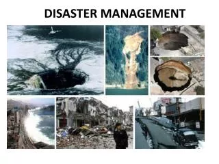
OVERVIEW • WIDELY APPLICABLE to many Users (Local & Remote), Inter & Extra Institutional • ADAPTABLE to many Disaster Scenarios (Storm,Flood, Quake) AND Health, Environmental, Mass • SUPPORTS many phase of disasters (Preparedness, Mitigation, Response, Recovery)
CASE STUDYIdentify the Information requirements of a Hazard Management System (HMS) for a national disaster Stakeholder
GROUP ASSIGNMENT - Stakeholders • Town & Country Planning • Public Utilities & Infrastructure • Environment & Health • Police, Emergency Services, SAR • Community & Local Government • Private Sector, (Commerce, Industry Agriculture)
Assignment Deliverables 1 - Information Needs What, When, Why, How • Example – Works Department needs – Risk report for roads, bridges, embankments, etc. 2 - Data Inputs (Source, format..) • Example - Digitized Topology Maps, Population Demographics, etc.i
Selected Regional Initiatives • CAREC / CARISURV • ODPEM / Jamaica DM • BVI – GIS System • UWI - CARDIN • CDERA – Hazard Mapping, Shelter Management, Community Outreach CDMP • CIMH – Modelling / Simulations/ Research / Training
HMS Components • INPUT/ACQUIRE DATA • ANALYZE / LNTEGRATE • DISTRUBUTE / REPORT
Data Sources • Remote Sensing – Satellite Imagery, Aerial Photographs • Geo-Spatial Representations- Hazard Maps, Topologic Features, Surveys, Demographics, Infrastructure • Asset Inventoty- Housing, Crops, Environment, Community Assets • Disaster Information – Sensor data , Field reporting
Models, Formulae, Parameters • Flood Plain Discharge - Intake • Effects of water on community, property, crops, infrastructure, infrastructure • Direct / Indirect costs, etc. by type of asset • How best to representation Hazard - Maps, Tables, Graphs, Reports, E-Broadcasts , “What-If” simulations • Historical; Data
Handhelds, PDAs & Portables Windows PC Software Easy-to-Program Creates database Multiple data formats Stylus, touch screen GPS-enabled Uploading to central database
Size – 10” x 10” Weighht - < 1.5 Kg Quick PC setup Low Power Indoor & Outdoor Mobile, Marine Use ~ 450 kbps TCP/IP & Voice Portable Satellite Terminals
Information Integration & Analysis • GIS – Mapping, Layers, supporting numerical information (e.g. HAZUS) • Databases – Multimedia digitized data, graphic / video, voice • Document Management – Real-time, Historical, Forecast, Simulation • Information Analysis – Simulations, Statistical Analysis,
ICTs at the NEOCs • Application Servers – GIS, Database • Networks / Connectivity • Internet Communications • Website, Portals, E-Mail, E-Newsletters, Group Lists • Telephony (landlines, Cell, SMS), VoIP, HAM, SatPhones
Dissemination / Reporting • Website & Portal Access • Map-based Hazard representation • Map-based Situation Management • Voice communications E-Mail, RSS, Text messaging • Reports, Documents & Analyses (summary & detail)
Assignment Select appropriate ICTs for use in the Hazard Management System (HMS)
Application Components • Input and Acquisition of Data • Analysis and Integration of Information • Reporting and Distribution of Information
HMS Success Criteria .. • High-value, sustainable application • Effective Field-NDM communications • Timely, Relevant, Accurate Information flows • Rugged, Affordable, Easy-to-Use ICT • Standards-based hardware, software & communications
Discussion of Issues • Implementation • Operations and Support • Organizational • Extension / Expansion of HMS
Wrap-Up • Review of Topic • Resources • Evaluation
Examples of Technology - Input • MS Visual Studio • PDAs & Handheld PCs – HP, Toshiba, Dell • Portable Satellite Terminals – Hughes, Thrane & Thrane, Nera • Satellite Service – INMARSAT (BGAN) (Region-wide Footprint) • ITU / Thuraya; Iridium/Raytheon
Examples of Technology - Integration • ESRI ArcGIS • SAS / GIS Statistical Software • LAMP (Linux, Apache, MySQL, PHP) • RealNetworks Helix Streaming Suite
Examples of Technology - Reporting • Crystal Report Generator • ArcExplorer (ESRI) • RSS Server • Constant Contact – E-Newsletters • Open ACS -Website Content Manager
Review • ICTs in Disaster Management • References • Evaluation
Partial List of Web Sites • http://training.esri.com/campus/home/workshoplist.cfm?id=3&CFID=5144395&CFTOKEN=85096683 • http://www.cto.int • http://www.cdera.org • http://www.carec.org/ • http://www.cimh.edu.bb/
Partial List of Web Sites • http://msdn.microsoft.com/vstudio/ • http://www.hp.com/country/us/en/prodserv/handheld.html • http://broadband.inmarsat.com/about/explorer_700.aspx?language=EN&textonly=False • http://broadband.inmarsat.com/default.aspx?language=EN&textonly=False
Web Sites (Continued) • http://www.esri.com/ • http://www.realnetworks.com/index.html • http://www.sas.com/products/gis/ • http://www.crystalreports.co.uk/ • http://search.constantcontact.com/index.jsp