Download
1 / 39
390 likes | 571 Views
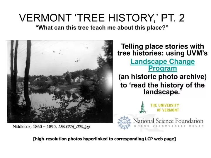
VERMONT ‘TREE HISTORY,’ PT. 2 “What can this tree teach me about this place?”. Telling place stories with tree histories: using UVM’s Landscape Change Program (an historic photo archive) to ‘read the history of the landscape.’ . Middlesex, 1860 – 1890, LS03976_000.jpg

E N D
VERMONT ‘TREE HISTORY,’ PT. 2 “What can this tree teach me about this place?” Telling place stories with tree histories: using UVM’s Landscape Change Program (an historic photo archive) to ‘read the history of the landscape.’ Middlesex, 1860 – 1890, LS03976_000.jpg [high-resolution photos hyperlinked to corresponding LCP web page]
Trees & photographs can each be visual ‘record-keepers,’ full of historic information.What history does this photo of a tree stump represent?(probably wind erosion of delta sand) “Pine stump near Georgia Station” between 1860-1890.LS00413_000.jpg
Tree stories are place stories. “Men planting scotch pine” Plainfield, May, 1911. LS08105_000.jpg “People in field.” Plainfield, June, 1911. Inspecting the surviving scotch pine after spring storm. LS06445_000.jpg These two photos beg the question: why would so many people care about a field of scotch pine saplings?
Erosion impacts whole communities …and even entire watersheds. The White River, Sharon, 1927. LS01450_000.jpg The same spot, 2004. LS01450_001.jpg Trees and other vegetation retain the soil on riverbanks and sloping hillsides by slowing down the flow of water as well as by ‘holding it down’ with their roots.
Tree places & ‘treescape’ history • Dooryards • Street trees • Parks • Riverbank (riparian zone) • Farms • Forests • Ecosystem Services • Tree enemies & events Rudyard Kipling pines. Dummerston, 2003 LS11425_000.jpg
The Dooryard Tree East Calais, July 1926. LS06904_000.jpg According to some foresters, the maples growing in front of most old farmhouses were usually planted or intentionally spared when the building site was cleared because of the exceptional shade they cast, as well as their beautiful fall color. Lilac bushes are also a traditional dooryard variety. Although many yard & garden fashions have changed over time, dooryard lilacs & sugar maples are still very common in Vermont ‘dooryards.’
Apple trees in the dooryard LS04740_000.jpg Stereoscope of David Horton’s dooryard. 1877, Montpelier. Q: Although this image is in rough condition, it would appear that Mr. Horton’s apple tree was in even worse condition than that… what had recently happened that might account for things looking so neglected… ? A: Much of Vermont’s able-bodied male population had gone to fight for the Union in the Civil War, and many never returned. Some hung their sickle from a tree in the front yard as a symbol that their families were without them. Widows of the fallen would often leave the sickle in the tree as a memorial. Sawmill operators will occasionally find one grown into an old “sickle tree” that’s been brought down.
Summer homes & inns Tourism has been an important industry to Vermont for more than 100 years. This has meant that, among other reasons, there have long been economic incentives to preserve ‘scenic beauty.’ Franklin, after 1910… 1918? “Camp Patten, Lake Carmi.” LS01653_000.jpg
In choosing a yard tree… Between 1907-1915, Washington. LS01988_000.jpg …one must consider many factors. Some trees grow fast, others slow; some very big, others not. As you can see, the willows growing close to this house grow to be quite large. Because they have ‘thirsty’ roots that can damage pipes, and are also known to have brittle branches, the homeowners here may have later wished the trees were further from the house. The young maples in the forefront were commonly chosen as ‘yard trees.’
Roadside and Street Trees Somewhere in Vermont, 1914.LS06477_000.jpg Washington County, 1913?LS06063_000.jpg Roadside trees have frequently been victims of progress. For example: the need to widen streets, install utility lines and dig channels for underground for water, sewer and/or gas pipes meant removing them or fatally damaging their roots. American elms were once a common sight along streets and roads. In photos taken after the 1960s, however, it is rare to find more than one or two elms in any picture. Dutch elm disease, introduced by overseas trade, is still killing elm trees today.
The “Good Roads” movement 100 years ago (and earlier in Europe), pleasure rides in carriages-- and later, by bicycle or automobile-- were a popular leisure activity among the wealthy. In earlier days, scenic carriage and bridle paths were only on private estates. When bicycles and then the automobile brought leisure riders to the countryside, they found highways and roads to be far less enjoyable than their well-tended lanes and ‘allees.’ In the early 1900s, they rallied the federal government to organize and fund the improvement of public roads, making a convincing case that good roads would benefit rural (often low-income) people…not just those desiring a smooth ride through pretty scenery. Eventually, laws would be established regarding vegetation along roads. At first, road crews were required to cut all vegetation away for visibility safety, but later the law was declared for shrubbery only, to protect and encourage planting of shade trees. Eventually, Vermont towns were required to appoint a tree warden to oversee the management of trees along public roadways. A diseased or dead tree is a threat to travelers, so someone should be keeping an eye on potential tree hazards and removing trees in danger of falling onto the road. Shelburne Farms, 1903. LS11594_000.jpg Built by wealthy New Yorkers who came to Vermont to build a ‘model farm,’ these carriage roads are open to the fee-paying public today and maintained by a non-profit foundation.
The changing roadside Rutland 1935 (?) and 2000, LS00023_000.jpg and LS00023_001.jpg When American elms grew in abundance along our roadside, the older image was a common sight. Besides the loss of elms to disease, the countryside has reverted to forest from pasture. The covered bridge helps to convince us that these photos show the same place. How might this road look today if the elms had not died?
The elm Route 2, St. Johnsbury No date. LS07805_000.jpg • Elm stumps, Burlington, 1965 LS11965_000.jpg • Dutch Elm Disease (DED, worst from 1940s to 1970s) devastated the urban landscape. College Street, Burlington Before 1922. LS11542_000.jpg American elms were native, and many communities were built around them. Later, the beloved tree was planted along roads & in parks across the continent. Their popularity was their doom: a beetle carrying a fungus that kills the tree could easily move across great distances by migrating on the wind from tree to tree.
Parks and public spaces Ethan Allen City Park, Burlington, 1937 and 2000. LS00092_000.jpg and LS00092_001.jpg The popularity of city parks in the United States blossomed with New York City’s Central Park in the 1870s. It became a fashion and then a cause for the urban elite to help create green spaces for the growing city populations. Ethan Allen City Park opened in 1905. It was once a popular place for music and dancing. Today cyclists, dog walkers and children enjoy themselves there. Many of the original trees remain.
Hubbard Park and the State House 1874. LS00410_000.jpg 2004. LS00410_001.jpg While we are not seeing late autumn in the early picture (because hardwood trees lose their leaves in autumn), and even with some trees already bare in the recent picture, the visual opposite of these two views of the State House mirrors Vermont’s famous transformation from a heavily cut-over countryside to forested landscape.
The UVM Green before & after DED 1986 LS10069_000.jpg Before 1951 LS10066_000.jpg Ira Allen designated the space we call the UVM green when he founded the college, and it has had many ‘faces.’ By the 1950s, American Elms completely defined the setting, creating a shaded oasis that both sheltered and inspired generations of students there. Consider the green 1980s students experienced, when (because Dutch elm disease took the elms) the trees were neither older nor taller than them.
Town Greens Before August, 1912.LS02567_000.jpg 1930 - 1940, St. Johnsbury.LS07346_000.jpg Town greens are a great place to look for tree history. While the Weston Common may not be round any more, it is probably still dominated by maples. The St. Johnsbury town green, however, is home to different trees than we see here– evergreen, crab apple, sugar maple and others. The town didn’t replace these elms with a single species, since monocultures are more vulnerable to epidemics.
Riverbank (riparian zone) LS07427_000.jpg Third Branch of the White River, Stockbridge. May 14, 1897 When trees are removed from the riverside, the banks become less stable and the water temperature can be affected. While the tree in the foreground is not positively identified, it is most likely a box elder. Box elder thrive alongside rivers and can survive floods and scraping ice. On the far bank, elms line the roadside. American elms prefer swampy sites, but can thrive in a variety of conditions.
Floodplain species A very old (probably black) willow– on Otter Creek. Between 1900 - 1950. LS08873_000.jpg Trees with roots that can go without oxygen longer have an advantage where flooding is the norm. Willows, which have distinctive, deeply furrowed bark when they are big, are so adapted. Willows don’t often reach 200 years, so its unlikely that the willow in this image is still alive. More likely, another willow has grown in its place: they grow fast enough that the same spot could look quite similar today!
Farms and Flooding Richmond, 1964 LS06451_000.jpg The economic circumstances of Vermont– an agricultural boom and then bust, the development of the railroads, a generation of men lost to the Civil War, and a lack of major industry were all factors in the clearing and subsequent re-growth of forestlands. Where trees were kept at bay for farming, the fertile farm soil was vulnerable to being washed into the rivers during heavy rains.
Agricultural history Where–and when was this farm? Do you think it looks like this now? (LS08865_000.jpg) Hill farms once dotted the mountains, but most have since reverted to forest. Imagine the fields of farms since past, the next time you peer through the stems of a young upland forest. Stone walls still show former fence and property lines, standing as testimony that the land was once cleared and tilled for food crops and animal husbandry. The use of this field by the sheep shown above probably influenced what vegetation would re-grow there, and likely impacted soil quality over time.
Hard work, sweet rewards Greensboro, no date. LS02684_000.jpg New Haven, turn of the century. Picking Strawberries LS00537_000.jpg Apples, berries and maple syrup are still important crops in today’s Vermont agriculture. In the 1940s, to apply science in the improvement of maple syrup production, a maple research farm was built and named for then-Governor Mortimer Proctor in Underhill. Mazza Farm and Adam’s Berry Farm are two among many that grow delicious berries for pick-your-own or market.
Vermont Forests Stamford - Readsboro, late summer, 1963. LS09460_000.jpg Before 1922. LS01712_000.jpg More than 100 years ago (in 1882), a state commission was appointed to investigate and make recommendations for the future management of Vermont’s forest resources. Arbor Day was first observed here in 1885.
78% forested, once 60% farmed Ascutney Mountain, Weathersfield. Before 1969. LS05967_000.jpg August, 2005. LS05967_001.jpg Did you know that from 1907 into the 1940s, more than 28 million trees were raised at the State Tree Farm in Essex and planted on private and municipal land as well as in state forests under the Agricultural Conservation program? Red, white and scotch pine; Norway, red and white spruce; balsam fir, European Larch, Arbor Vitae, Black Locust and White Ash were cultivated.
LS02113_000.jpg Cutting in the woods, planting in town: by the 1880s, townspeople were encouraged by state government to start planting shade trees along their village streets. At the same time, forest timber harvests were ever-increasing.
Succession “Beautiful reproduction of sugar maples, Downer State Forest, Sharon.”LS05735_000.jpg “Second Growth White Pine.” UVM Forest, no date. LS05765_000.jpg The UVM Jericho Research Forest began experimenting with reforestation and replenishment of soil nutrients beginning in 1941, but earlier reforestation research was initiated by the state at the Downer Tree Nursery and state forest and saplings were propagated for farmland restoration at the Essex State Tree Farm as early as 1907.
Still a managed, working landscape LS00256_001.jpg LS00256_000.jpg “View from hill” showing village center Jericho, between 1860-1897. Schillhammer Road area, May 1, 2000. While some of the open spaces we treasure in Vermont are protected by land trusts and conservation easements, many hayfields and pastures are kept open by their continued use by dairy farmers. Other open spaces have reverted to managed forests. Timber production has been an important part of Vermont’s economy since at least 1899, that year estimated to be the second biggest ‘crop’ in the state.
Natural and human-caused occurrences 1924, Waterford. LS06738_000.jpg& LS08119_000.jpg Planting monocultures resulted in concentrations of disease and insect infestations that would lead foresters to the realization that species diversity is important to forest health. Fungus such as Pine Blister rust and bugs like gypsy & brown tail moths and San Jose Scale killed many of Vermont’s planted and self-regenerated trees in the early part of the 20th century. Later, Dutch Elm disease devastated the elm population and now a fungal ‘blight’ attacks beech and butternut, hemlock wooly adelgid and emerald ash borer are serious threats to the future diversity of species in Vermont forests.
“Events happen” ‘Man-made’ or a ‘natural’ disaster? LS06042_000.jpg UVM Green, 1950 hurricane. LS10226_000.jpg While storms wreck havoc on managed and wild landscapes alike, the land use and land-altering decisions humans make can often be equally implicated, such as the removal of vegetation along roadsides or the placement of trees in a landscape that may or may not be best-suited for the species chosen.
Nature’s course Damage from the Hurricane of ’38 LS05616_000.jpg Before 1968, satin moth. LS06173_000.jpg Blow-downs are an important element in the evolution of forests. Open patches create new habitat by changing the amount of light and rain in the disturbed setting. Infestations by damaging insects such as the satin moth also help define changes in species composition by giving under story plants a competitive edge; notice how the other trees in the photo on the right all have leaves while the maples are bald.
Time- and place-keepers 2005, UVM. LS10825_001.jpg 1970, UVM. LS10825_000.jpg While the low-hanging limb has since been pruned away, it’s easy to see from the buildings that this 2005 image is of the same tree in photographed in 1970. The placement is confirmed by the buildings in the background, and if there was doubt, the age of the tree in the ’05 photo is definitely more than 25 years!
Ecosystem Services LS02112_000.jpg What were these trees doing in the woods? Literally: creating oxygen, creating debris that would become soil, feeding microorganisms, providing habitat and/or food for birds, bats, mammals and insects, regulating the sunlight (& therefore plants growing) beneath them, retaining moisture and evaporating water. When they became lumber, these services were in short supply and the landscape changed in many more ways than the eye can see. These trees were floated down the river to become buildings, furniture, paper, and fuel for factories, steamboats, trains, and warmth.
Trees provide shelter…and a whole lot more • Habitat: in forests and streams (even dead trees are useful!) • Water purification (evaporation) • Soil nutrients (decomposing wood, leaves, fruit/nut/seed) • River/stream water temperature (shade!) • CO2 storage, oxygen generation (trees breath in what we breath out and breath out what we breath in) • Connection with non-human life (humans sometimes need reminders that we aren’t the only living beings who shape the landscape) LS05762_000.jpg
Tree and forest history is intertwined with human history. LS06457_000.jpg This is an American Chestnut, once one of the dominant and most important trees in Northeastern North America. Very few are still alive today after a blight killed vast numbers of them in the early 20th century. Would the Chestnut blight have been transported to North America from Asia if Europeans had not migrated here and then imported foreign plants and pests through international trade? Taking a couple of steps back, would the Europeans have had seaworthy ships to cross the Atlantic without their (once vast) oak and pine forests?
Which tree is that? review State House, Montpelier. Before 1885. LS05726_000.jpg The classic fountain shape, the great shade it cast and the relative durability of the American Elm were among the traits that made it the tree that symbolized American culture in its heyday. The species became an icon during the American Revolution, after a rowdy protest of taxation without representation near an elm-shaded pub in Boston. An effigy of the British tax collector was hung from a low branch, and the sign nailed to its trunk declaring it “The Liberty Tree” was soon copied on American Elms in rebel strongholds across New England.
What is the history of this landscape? August, 1907. Probably an ash tree. Saint Albans pasture.LS07397_000.jpg The geologic history of a site originally determined the minerals there, and then later human land use may change the nutrient content of the soil, which in turn would determine what plants (and animals) would thrive there.
How can you interpret landscape history by looking at historic photos of trees? Before 1916, UVM Green. LS10360_000.jpg August, 2005. LS10360_001.jpg Compare an historic photo with a more recent image of the same location. Note which of the original trees appear to still exist. Pay attention to changes in species composition– what may account for that? Compare the size of the trees from the past with the recently photographed ones: are the trees older and bigger, or are they replacing the earlier trees? What may account for any damage you see? Ask yourself: based on the way it is managed and used today, what will this landscape look like many years into the future?
Be your own tree detective Benson, 1966. LS08806_000.jpg Leaves & buds are not the only identifying characteristic of trees. The growth form or shape, the bark (but careful: young tree bark looks different than mature tree bark), characteristics such as what kind of habitat they’re found in and what kinds of other vegetation are found growing nearby can also help in identifying a tree.
Trees are ‘history-keepers’ LS12007_000.jpg LS04065_000.jpg After 1940, Burlington. Taking down a poplar. Burke, 1939. Are they replacing hurricane-downed trees? If you use historic photo collections to explore your landscape’s past, you may realize how some of the ways you live will shape it for future generations. Lesson 2 of 2, created in 2007 by Loona Brogan for the University of Vermont’s Landscape Change Program with funding from The National Science Foundation.