Download
1 / 36
360 likes | 370 Views
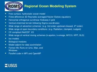
2003 Terrain-Following Ocean Models Users Workshop. Regional Ocean / Atmosphere Coupled Modeling System for the Southeastern Brazilian Coast. Maurício da Rocha Fragoso LAMMA – Universidade do Brasil. 2003 Terrain-Following Ocean Models Users Workshop. Presentation Topics. 1 LAMMA

E N D
2003 Terrain-Following Ocean Models Users Workshop Regional Ocean / Atmosphere Coupled Modeling System for the Southeastern Brazilian Coast Maurício da Rocha Fragoso LAMMA – Universidade do Brasil
2003 Terrain-Following Ocean Models Users Workshop Presentation Topics 1LAMMA 2THE SOUTHEASTERN BRAZILIAN COAST 3MODEL COUPLING 4THE MOREA SYSTEM 5NEXT STEPS > LAMMA \ UFRJ www.lamma.ufrj.br
2003 Terrain-Following Ocean Models Users Workshop 1. LAMMA 1.1. Location Marine and Atmospheric Processes Modelling Laboratory Universidade do Brasil - Rio de Janeiro Meteorology Department > LAMMA \ UFRJ www.lamma.ufrj.br
2003 Terrain-Following Ocean Models Users Workshop 1. LAMMA 1.2. Staff Oceanographers, Meteorologists and Environmental Engineers Graduate and Undergraduate students and researchers Associated Researchers (Brazilian and foreign institutions) > LAMMA \ UFRJ www.lamma.ufrj.br
2003 Terrain-Following Ocean Models Users Workshop 1. LAMMA 1.3. Research Areas Agrometeorology Ocean/Atmosphere Processes Chief Sc.: Audalio Torres Jr. Atmospheric Pollution Remote Sensing Coastal and Oceanic Circulation Pollutant Transport Surface Waves Atmospheric Modeling > LAMMA \ UFRJ www.lamma.ufrj.br
2003 Terrain-Following Ocean Models Users Workshop 1. LAMMA 1.4. Ocean/Atmosphere Processes Research Forecasting Systems development Marine Currents Surface Waves Atmosphere Model Coupling Global -> Regional Wave/Current /Atmosphere Transport Models Development Oil Sewage Particles Atmosphere > LAMMA \ UFRJ www.lamma.ufrj.br
2003 Terrain-Following Ocean Models Users Workshop 1. LAMMA 1.5. POM in LAMMA Since 1996 we’ve been applying POM in the Brazilian coast, from basin to small scales POM implementations by LAMMA > LAMMA \ UFRJ www.lamma.ufrj.br
2003 Terrain-Following Ocean Models Users Workshop 1. LAMMA 1.5. POM in LAMMA South Atlantic Ocean (5000 X 9500 Km) > LAMMA \ UFRJ www.lamma.ufrj.br
2003 Terrain-Following Ocean Models Users Workshop 1. LAMMA 1.5. POM in LAMMA Ilha Grande Bay Rio de Janeiro, Brasil (100 X 200 Km) > LAMMA \ UFRJ www.lamma.ufrj.br
2003 Terrain-Following Ocean Models Users Workshop 1. LAMMA 1.5. POM in LAMMA Ilha Grande Bay Rio de Janeiro, Brasil Ballast Water Dispersion Program GloBallast -IMO > LAMMA \ UFRJ www.lamma.ufrj.br
2003 Terrain-Following Ocean Models Users Workshop 1. LAMMA 1.5. POM in LAMMA Todos os Santos Bay Bahia, Brasil (55 X 32 Km) > LAMMA \ UFRJ www.lamma.ufrj.br
2003 Terrain-Following Ocean Models Users Workshop 1. LAMMA 1.5. POM in LAMMA Guanabara Bay Rio de Janeiro, Brasil (25 X 32 Km) > LAMMA \ UFRJ www.lamma.ufrj.br
2003 Terrain-Following Ocean Models Users Workshop 1. LAMMA 1.5. POM in LAMMA Amazon River Amazonia, Brasil (~3 X 60 Km) > LAMMA \ UFRJ www.lamma.ufrj.br
2003 Terrain-Following Ocean Models Users Workshop 2. The Southeastern Brazilian Coast 2.1. Location > LAMMA \ UFRJ www.lamma.ufrj.br
2003 Terrain-Following Ocean Models Users Workshop 2. The Southeastern Brazilian Coast 2.2. Importance Major Brazilian Cities Major Ports of Brazil 70% of Brazilian Oil Production > LAMMA \ UFRJ www.lamma.ufrj.br
2003 Terrain-Following Ocean Models Users Workshop 2. The Southeastern Brazilian Coast 2.3. Center For Oil Spill Monitoring at Sea - CeMOM In 2001 the Center for Oil Spil Monitoring at Sea (CeMOM) of the Brazilian Petroleum Agency was created The mission of CeMOM is to monitor natural and accidental oil spills in Brazilian coast > LAMMA \ UFRJ www.lamma.ufrj.br
2003 Terrain-Following Ocean Models Users Workshop 2. The Southeastern Brazilian Coast 2.3. Center For Oil Spill Monitoring at Sea - CeMOM The detection of oil is made through SAR images Once detected an oil spill trajectory forecast is performed > LAMMA \ UFRJ www.lamma.ufrj.br
2003 Terrain-Following Ocean Models Users Workshop 2. The Southeastern Brazilian Coast 2.3. Center For Oil Spill Monitoring at Sea - CeMOM Hydrodynamics is provided by POM applied operationally to this region Boundary and initial conditions prescribed by values found in literature > LAMMA \ UFRJ www.lamma.ufrj.br
2003 Terrain-Following Ocean Models Users Workshop 2. The Southeastern Brazilian Coast 2.3. Center For Oil Spill Monitoring at Sea - CeMOM > LAMMA \ UFRJ www.lamma.ufrj.br
2003 Terrain-Following Ocean Models Users Workshop 2. The Southeast Coast of Brazil 2.3. Meteoceanography Highlights Brazil Current – Meanders and Eddies Vitória-Trindade Ridge Upwelling Sea Breeze > LAMMA \ UFRJ www.lamma.ufrj.br
2003 Terrain-Following Ocean Models Users Workshop 2. The Southeastern Brazilian Coast 2.3. Meteoceanography Highlights > LAMMA \ UFRJ www.lamma.ufrj.br
2003 Terrain-Following Ocean Models Users Workshop 2. The Southeast Coast of Brazil 2.3. Meteoceanography Highlights > LAMMA \ UFRJ www.lamma.ufrj.br
2003 Terrain-Following Ocean Models Users Workshop 3. MODEL COUPLING 3.1. Why Ocean/Atmosphere Coupled Model ? SST has strong influence in ocean/atmosphere processes of region Sea Breeze intensification by upwelling Upwelling intensification by sea breeze In order to try to capture most part of the ocean/atmosphere dynamics of the regionwe chose to apply a coupled model > LAMMA \ UFRJ www.lamma.ufrj.br
2003 Terrain-Following Ocean Models Users Workshop 3. MODEL COUPLING 3.2. First Attempt -RAMS/POM How to match software engineering ? POM as a subroutine of RAMS Performace of the coupled system very similar to RAMS alone > LAMMA \ UFRJ www.lamma.ufrj.br
2003 Terrain-Following Ocean Models Users Workshop 4. THE MOREA SYSTEM Coupling the GFDL Princeton Ocean Model (POM) with PSU/NCAR Mesoscale Modeling System (MMS) Intends to be a diagnostic and prognostic system of ocean and atmosphere, in regional scale, of the southeastern Brazilian coast > LAMMA \ UFRJ www.lamma.ufrj.br
2003 Terrain-Following Ocean Models Users Workshop 4. THE MOREA SYSTEM 4.1. POM Grid: 10o S – 27o S / 50o W – 30o W Spatial Resolution: 5’ (~9Km) Grid Size: 205X240X15 Boundary and Initial Conditions provided by MOM data SST Boundary Conditions provided by GOES/INPE > LAMMA \ UFRJ www.lamma.ufrj.br
2003 Terrain-Following Ocean Models Users Workshop 4. THE MOREA SYSTEM 4.1. POM POM for SE Braz. coast with inital and boundary conditions provided by MOM data > LAMMA \ UFRJ www.lamma.ufrj.br
2003 Terrain-Following Ocean Models Users Workshop 4. THE MOREA SYSTEM 4.2.MM5 Grid: 10o S – 27o S / 50o W – 30o W Spatial Resolution: 5’ (~9Km) Grid Size: 205X240X23 Atmospheric Boundary and Initial Conditions provided by NCEP model data > LAMMA \ UFRJ www.lamma.ufrj.br
2003 Terrain-Following Ocean Models Users Workshop 4. THE MOREA SYSTEM 4.2.MM5 MM5 for SE Brazil with inital and boundary conditions provided by NCEP model data > LAMMA \ UFRJ www.lamma.ufrj.br
2003 Terrain-Following Ocean Models Users Workshop 4. THE MOREA SYSTEM 4.3. SST DATA Simple SST images treatment for removal of cloud contaminations 48 GOES images per day Finds pixels with clouds and go backwards in time untill free pixel is found Gaussian interpolation for smoothing of image > LAMMA \ UFRJ www.lamma.ufrj.br
2003 Terrain-Following Ocean Models Users Workshop 4. THE MOREA SYSTEM 4.3. SST DATA > LAMMA \ UFRJ www.lamma.ufrj.br
2003 Terrain-Following Ocean Models Users Workshop 4. THE MOREA SYSTEM 4.3. SST DATA > LAMMA \ UFRJ www.lamma.ufrj.br
2003 Terrain-Following Ocean Models Users Workshop 4. THE MOREA SYSTEM 4.4.COUPLING STRATEGY POM as a subroutine of MM5 Interpolation of fields to match grids Variables are exchanged with frequency depending on time scales POM to MM5: SST MM5 to POM: 10 m wind, atmospheric pressure, radiation > LAMMA \ UFRJ www.lamma.ufrj.br
2003 Terrain-Following Ocean Models Users Workshop 5. NEXT STEPS Implementation of Modular Ocean Model MOM/CCM coupling MM5 to WRF > LAMMA \ UFRJ www.lamma.ufrj.br
2003 Terrain-Following Ocean Models Users Workshop Acknowledgments Organizing Committee Brazilian Petroleum Agency - ANP LAMMA / LAMCE Staff > LAMMA \ UFRJ www.lamma.ufrj.br
2003 Terrain-Following Ocean Models Users Workshop Visit our Website www.lamma.ufrj.br > LAMMA \ UFRJ www.lamma.ufrj.br