Download
1 / 42
430 likes | 584 Views
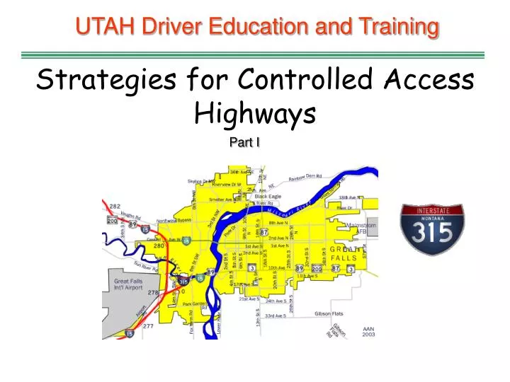
UTAH Driver Education and Training. Strategies for Controlled Access Highways. Part I. Standards and Benchmarks. 1. Laws and Highway System a. know the laws outlined in the Utah Driver's manual b. understand the laws outlined in the Utah Driver's manual

E N D
UTAH Driver Education and Training Strategies for Controlled Access Highways Part I
Standards and Benchmarks • 1. Laws and Highway System • a. know the laws outlined in the Utah Driver's manual • b. understand the laws outlined in the Utah Driver's manual • c. consistently demonstrate knowledge and understanding by responsible adherence to highway transportation system traffic laws and control devices • 2. Responsibility • b. demonstrate the ability to make appropriate decisions while operating a motor vehicle • c. consistently display respect for other users of the highway transportation system • d. develop habits and attitudes with regard to responsible driving • 3. Visual Skills • a. know proper visual skills for operating a motor vehicle • b. communicate and explain proper visual skills for operating a motor vehicle • c. demonstrate the use of proper visual skills for operating a motor vehicle • d. develop habits and attitudes with regard to proper visual skills • 4. Vehicle Control • a. demonstrate smooth, safe and efficient operation of a motor vehicle • b. develop habits and attitudes relative to safe, efficient and smooth vehicle operation.
Standards and Benchmarks 5. Communication a. consistently communicate their driving intentions (i.e., use of lights, vehicle and personal signals) b. adjust their driver behavior based on observation of highway transportation system and other users c. adjust communication (i.e., use of lights, vehicle and personal signals) based on observation of highway transportation system and other users d. develop habits and attitudes relative to effective communication 6. Risk Management a. understand driver risk-management principles b. demonstrate driver risk-management strategies c. develop driver risk-management habits and attitudes 7. Lifelong Learning a. understand past, present and future vehicle and roadway design, and driving cultures c. understand benefits of a lifelong learning approach to driving e. identify opportunities for lifelong education in driving 8. Driving Experience a. acquire at least the minimum number of BTW hours over at least the minimum number of days, as required by law, with a Utah approved driver education instructor b. be encouraged to acquire additional BTW driving experience with their parent or guardian's assistance in a variety of driving situations (i.e., night, adverse weather, gravel road, etc.).
Introduction to Controlled Access Highways • Plans for the “Interstate System," began in the late 1930s • The system was created in 1956 and named for President Dwight Eisenhower • Without a system of interstate highways, life in America would be far different • It would be more risky, less prosperous, and lacking in the efficiency and comfort that Americans now enjoy and take for granted Source: The US Interstate Highway System: 40 Year Report American Highway Users Alliance., June 1996
KEY FACTS ABOUT UTAH’S INTERSTATE HIGHWAY SYSTEM • The Dwight D. Eisenhower National System of Interstate and Defense Highways, which has • been called the most ambitious public works project built since the Roman Empire, is the most • critical link in Utah’s transportation system. • • Utah has 940 miles of Interstate routes running the length of the state and connecting the • state’s major urban areas. • • Utah’s Interstate system, which includes five percent of all roadway lane miles in the state, • carries 36 percent of all vehicle travel in the state. • • Since funding of the Interstate system was approved in 1956, vehicle miles of travel in • Utah have increased by 645 percent, the state’s population has nearly tripled, increasing by • 195 percent, from 810,000 to approximately 2.4 million and the number of vehicles in • Utah has increased by 489 percent. • The state’s Interstate Highway System saves the average Utah resident $2,941 per year -- $7 • billion statewide -- in reduced accident costs such as medical expenses and lost productivity, the • value of saved time and fuel, and reduced apparel, food, housing and transportation costs. • • By reducing travel times, the Interstate system saves each Utah resident 104 hours of travel • time annually – 248 million hours statewide. • • Utah’s Interstate system annually reduces statewide motor fuel consumption by 118 • million gallons. • • Consumer costs have been significantly lowered by the Interstate Highway System. The • cost of transporting goods has been reduced because the time it takes to make trips has • been decreased. • • The following chart indicates the total annual savings per person and statewide of the • Interstate system. • Per Person Statewide (millions) • Safety $132 $316 • Time and Fuel $1,667 $3,982 • Reduced Consumer Costs $1,142 $2,728 • Total $2,941 $7,026
Characteristics • The words “limited” and “controlled” access highways are interchangeable with “freeways” and “expressways” • Travel on these highways is limited to motor vehicles • Drivers are limited as to where they can enter and exit • Drivers have minimum and maximum speed limits • Opposing traffic has some type of barrier (median grass strip, guardrail, concrete wall, etc.) • There are multiple lanes in both directions • They are designed to carry lots of traffic quickly and efficiently • Distance between entrance and exit locations may only be a mile apart or many miles apart
Characteristics • The U.S. Interstate Highway System has enriched the quality of life for every American • It provides virtually all Americans with the ability to move quickly to any destination within their communities and to travel throughout the nation, inexpensively, and at whatever time or date they desire Photo courtesy of http://americanhistory.si.edu/onthemove/exhibition/exhibition_16_7.html
Characteristics • There is a high injury severity rate when a collision occurs because of the higher speeds • On UTAH interstates, 2,460 collisions occurred during 2004 causing 38 fatalities Photo courtesy of AAA Foundation
Did you know in 2007: • • 61,245 motor vehicle crashes occurred in Utah which resulted in 27,420 injured persons and 299 • deaths. • • 2007 had the highest number of crashes ever on public roadways in Utah. • • A motor vehicle crash occurred in Utah every 8 minutes, a person was injured in a crash every 19 • minutes, and a person died in a crash every 29 hours.
Emergency Crossovers • Emergency crossovers on limited access roadways are restricted to emergency or law enforcement vehicles only • Driving in these restricted areas can result in a large fine Photo courtesy of http://www.photodiary.org/kw_freeway.shtml
Interstate Highway System Fascinating Facts • Interstate By the Numbers • Official Name: Dwight D. Eisenhower National System of Interstate and Defense Highways Total Miles: 46,837 (2004) • Longest Interstate Routes:I-90, Seattle, Washington to Boston, Massachusetts, 3,020.54 milesI-80, San Francisco, California to Teaneck, New Jersey, 2,899.54 milesI-40, Barstow, California to Wilmington, North Carolina, 2,555.40 milesI-10, Los Angeles, California to Jacksonville, Florida, 2,460.34 milesI-70, Cove Fort, Utah to Baltimore, Maryland, 2,153.13 milesShortest Two-Digit Interstate Routes:I-73, Emery to Greensboro, North Carolina, 12.27 milesI-97, Annapolis to Baltimore, Maryland, 17.62 milesI-99, Bedford to Bald Eagle, Pennsylvania, 53.00I-19, Nogales to Tucson, Arizona, 63.35 milesI-66, Strasburg, Virginia to Washington, D.C., 74.80 milesShortest Three-Digit Interstate Routes:I-878, 0.70 miles, New YorkI-395, 0.72 miles, MarylandI-980, 0.80 miles, CaliforniaI-315, 0.82 miles, MontanaI-110, 0.94 miles, TexasNorth-South Transcontinental Routes:I-5 San Diego, California to Blaine, Washington, 1,381.29 milesI-15, San Diego, California to Sweetgrass, Montana, 1,433.52 milesI-35 Laredo, Texas to Duluth, Minnesota, 1,568.38 milesI-55, New Orleans, Louisiana to Chicago, Illinois, 964.25 milesI-65, Mobile, Alabama to Gary, Indiana, 887.30 milesI-75, Miami, Florida to Sault Ste. Marie, Michigan, 1,786.47 milesI-95, Miami, Florida to Houlton, Maine, 1,919.74 milesStates with Most Interstate Miles:Texas, 17 routes, totaling 3,233.45 milesCalifornia, 25 routes, totaling 2,455.74 milesIllinois, 23 routes, totaling 2,169.53 milesPennsylvania, 22 routes, totaling 1,759.34 milesNew York, 29 routes, totaling 1,674.73 milesStates with Most Interstate Routes:New York, 1,674.73 miles, 29 routesCalifornia, 2,455.74 miles, 25 routesIllinois, 2,169.53 miles, 23 routesPennsylvania, 1,759.34 miles, 22 routesOhio, 1,572.35 miles, 21 routesRoutes Traversing the Most States:I-95, 16 states (including Washington D.C.): Florida, Georgia, South Carolina, North Carolina, Virginia, Washington D.C., Maryland, Delaware, Pennsylvania, New Jersey, New York, Connecticut, Rhode Island, Massachusetts, New Hampshire, and Maine • I-90, 13 states: Washington, Idaho, Montana, Wyoming, South Dakota, Minnesota, Wisconsin, Illinois, Indiana, Ohio, Pennsylvania, New York, and Massachusetts • I-80, 11 states: California, Nevada, Utah, Wyoming, Nebraska, Iowa, Illinois, Indiana, Ohio, Pennsylvania, and New Jersey • I-70, 10 states: Utah, Colorado, Kansas, Missouri, Illinois, Indiana, Ohio, West Virginia, Pennsylvania, and Maryland • I-10, eight states: California, Arizona, New Mexico, Texas, Louisiana, Mississippi, Alabama, and Florida • All but five state capitals are directly served by the Interstate System. Those that aren’t are Juneau, Alaska; Dover, Delaware; Jefferson City, Missouri; Carson City, Nevada; and Pierre, South Dakota. • Oldest Segments: A portion of the Grand Central Parkway in Queens, New York, opened in 1936 and was later incorporated into the Interstate System as I-278; The Pennsylvania Turnpike between Irwin southwest of Pittsburgh and Carlisle west of Harrisburg opened in October, 1940, and is now I-76 and I-70. Interchanges: 14,750 (approximate) • Bridges: 55,512 (as of December 2004) • Tunnels: 82 (104 bores) • Highest Elevation: Eisenhower Memorial Tunnel, Clear Creek/Summit counties, Colorado 11,012 feet (east) and 11,158 (west) • Lowest Elevation: Interstate 8, El Centro, California, 52 feet below sea level
Tollbooths There are three types of tollbooths: 1. Automatic ─ the driver deposits coins into a machine, requiring the exact change before entering this tollbooth 2. Attendant Operated ─ for driver’s without exact change or large/oversized vehicles • Electronic ─ an electronic device is placed in the drivers vehicle, as the driver approaches the tollbooth, the device communicates with a computer that subtracts the amount electronically from a pre-paid account Photo courtesy of AAA Foundation
Toll Roads and Bridges Roads and bridges are generally paid for with fuel taxes They are talking about a toll road and bridge over utah lake going east and west. There were so many toll roads and bridges, the Legislature received complaints that tolls were seriously eating into business profits The system was abolished in 1872 Photo courtesy of the American Bridge Company The Snowden Bridge over the Missouri River charged tolls until 1956
High Occupancy Vehicle (HOV) Lanes • High-Occupancy Vehicle (HOV) lanes allow vehicles with two or more people to use diamond and express lanes • The goal of HOV lanes is to use the current freeway system more efficiently and to provide a quicker, more reliable trip to those who car pool
Collision and fatality rates are lower Cross traffic is not present Opposing traffic is separated by a barrier There are no stops Signs are large and placed well in advance Higher speed limits allow for fast, efficient travel ADVANTAGES OF LIMITED ACCESS ROADS
DISADVANTAGES OF CONTROLLED ACCESS HIGHWAYS • Lane selection is critical • Increased stopping distance • Small driving errors can be disastrous • Different size and weight of vehicles adds additional challenges • Rush hour congestion Photo courtesy of http://members.cox.net/mkpl/interchange/interchange.html
WORLD'S MOST COMPLEX INTER-CHANGE... HOUSTON , TEXAS
Highway Hypnosis • A dull or drowsy condition that can occur because of the concentration needed while driving long distances • It becomes worse when the driver’s eyes focus on the yellow line • Plan breaks and rest stops to combat highway hypnosis • Pull to a safe area for rest and sleep when tired
Velocitation • Unknowingly accelerating to a higher speed while driving is known as velocitation • When driving at faster speeds for a period of time the body adjusts and causes the driver to think the vehicle is going slower than it actually is Photo courtesy of AAA Foundation
TYPES OF CONTROLLED ACCESS ROADS Expressway • High-speed divided highway with more than one lane running in each direction Freeway/ Superhighway • Same as an expressway, but usually refers to highways without tolls Turnpike/ Tollroad/Tollway • Usually an expressway that drivers pay to use Beltway • A limited access highway that goes around a city/urban area Parkway • Wide landscaped divided highway, possibly limited to non-commercial vehicles • Generally there are few if any commercial businesses or offices on parkways
CLOVERLEAF INTERCHANGE Allows for interchange of two expressways or major roadways Allows minimal disruption of speed or movement
DIAMOND INTERCHANGE Allows for interchange of a major roadway with a secondary dual or multiple lane roadway Little room available for left turns onto freeway Traffic can build up on the ramps creating congestion
TRUMPET INTERCHANGE Allows for interchange of secondary two-way streets to a multiple lane roadway with minimal traffic mix
FRONTAGE ROAD INTERCHANGE Allows for interchange of vehicles using parallel secondary two-way or one-way roadways and a major multiple-lane roadway Allows drivers to exit a multiple-lane roadway and use the opposing frontage road to enter the multi-lane roadway in the opposite direction
SAFETY DESIGNS • Pedestrians, animals, non-motorized vehicles, and slow moving vehicles are prohibited • Fences restrict pedestrian and animal traffic • Wide shoulders and underpasses • Curves are banked • Sharp curves and steep grades are reduced or eliminated
Rumble Strips are corrugated road sections used to alert the driver through the noise tires make when driven over them Warn of approaching hazards Alert the driver that they are leaving the lane Breakaway support on signs and light poles are designed to break when struck by a vehicle Lessening the damage to the vehicle and injury to the occupants Photo courtesy of http://www.aaroads.com SAFETY DESIGNS
Guardrails prevent vehicles that leave the roadway from impact with retaining walls, fences, or other vehicles Crash barrels lessen the impact if a vehicle collides with a bridge or overpass support SAFETY DESIGNS
SAFETY DESIGNS • Changeable message signs warn drivers of traffic accidents, stalled vehicles, or other traffic problems
SAFETY DESIGNS • Runaway truck ramps are on downhill grades for use by large, semi-tractor trailers that have lost brake power and are unable to stop
INTERSTATE SIGNS Guide sign Interstate sign Speed limit Warning sign
INTERSTATE HIGHWAY NUMBERS • Even numbers go east-west (I-90, I-94) • Odd numbers go north-south (I-15) • Numbers begin in the west and get larger as they move east • Alternate routes are usually three-digit
INTERSTATE HIGHWAY NUMBERS • If the first digit is even, the alternate route goes around the city • If it is odd, it leads into the city (I-115, I-315)
Montana’s I-315 in Great Falls is 0.82 miles and is the second shortest highway in the nation
Red Yellow Green X X TRAFFIC SIGNALS • Traffic signals on expressways are rare • The most common use is to identify traffic lanes Open for travel Lane about to change or close Closed Prohibited
Lane Markings • Lane markings on expressways mean the same as on any other roadway • The HOV marking is unique to high occupant vehicles
SPEED LIMITS • The speed limit on limited access highways in UTAH is 75 mph outside urban areas of 50,000 population and 65 mph within urban areas of 50,000 population • These fixed speed limits are based on optimal road/weather conditions Source: Drivers Manual
MILE MARKERS • Usually green or white and have the word MILE along with a number - some just have the number • Mile markers show the number of miles from where the Interstate route entered a state • The counting always begins at the state line in the south (for north-south routes) and in the west (for east-west routes) • Mile marker numbers always get larger as drivers travel east or north
MILE MARKERS • Knowing how to read mile markers can help drivers know exactly where they are in their destination • Watching these numbers will be useful if a driver needs to call for assistance by giving an exact location • Exit numbers will be the same number as the mile marker as shown in the two pictures • Mile markers on roads off the Interstate system exist, however, the numbering system may be different from state to state—or even county to county