Download
1 / 24
240 likes | 356 Views
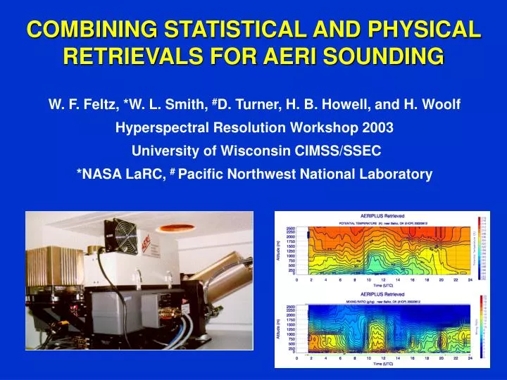
COMBINING STATISTICAL AND PHYSICAL RETRIEVALS FOR AERI SOUNDING. W. F. Feltz, *W. L. Smith, # D. Turner, H. B. Howell, and H. Woolf Hyperspectral Resolution Workshop 2003 University of Wisconsin CIMSS/SSEC *NASA LaRC, # Pacific Northwest National Laboratory. OVERVIEW.

E N D
COMBINING STATISTICAL AND PHYSICAL RETRIEVALS FOR AERI SOUNDING W. F. Feltz, *W. L. Smith, #D. Turner, H. B. Howell, and H. Woolf Hyperspectral Resolution Workshop 2003 University of Wisconsin CIMSS/SSEC *NASA LaRC, # Pacific Northwest National Laboratory
OVERVIEW • Instrument Overview (Description and Locations) • Retrieval Improvements • Hybrid First Guess Retrieval • Vertical resolution and fast model update • Temperature and Moisture Retrieval Statistics • Conclusions
AERI SPECIFICATIONS • Spectral Resolution better than 1 cm-1 wavenumber from 520-3000 cm-1 (3 - 20 um) • Calibrated to 1% ambient radiance (better than 1 K ambient temperature) • Automated and environmentally hardened • Time resolution: 6 - 10 minutes (adjustable) • Ground-based and portable
AERI SYSTEMS AROUND THE WORLD UW AERI - 2 (AERIBAGO, SSEC) DOE AERI - 8 (Kansas/Oklahoma, Alaska, S. Pacific) U-Miami M-AERI - 3 (Florida) Bomem AERI - 6 (Italy, California, Maryland, Canada) U Idaho P-AERI - 1 (Antarctica)
AERI Retrieval Flow Chart Radiosonde Climatology Regression Data Base T,Q Surface to 3 Km AERI Radiance Cloud Base Height (if present) Hybrid First Guess Physical Retrieval NWP Model/Satellite T,Q Profile 2 Km - Tropopause Temperature/ Moisture Profile Surface Moisture
AERIplus Retrieval Description • Two step retrieval, construct optimal first guess than conduct physical retrieval • Statistical retrieval is a combined regression and NWP profile • Physical retrieval used is iterative onion peel technique • Temperature and water vapor mixing ratio profiles retrieved from high resolution AERI spectra up to 3 km • Temporal resolution ~ ten minutes (increasing to < 1 minute) • Vertical resolution improved in lowest kilometer from 100 m to 50 m • Fast model update based on LBLRTM with HITRAN 2000 trans. coeffs • Constraints: AERI retrieval only possible in clear sky or below cloud base to 3 kilometers
Statistical Retrieval Description • Synthetic EOF Regression • ~1100 clear radiosondes from DOE ARM central facility near Lamont, Oklahoma for 1994-1996 • Forward calculations using 60-level fast model based on AER LBLRTM • EOF regression conducted relating each radiosonde – spectrum (562 channels) pair • Regression data set is very robust since a wide variety of weather is experiences in northern Oklahoma throughout the year
Hybrid First Guess • Statistical retrieval achieved during clear sky conditions (no update until a clear scene is present) • Statistical retrieval errors grow rapidly with altitude above one kilometer • Satellite profiles and NWP can be used to constrain the first guess through a simple linear interpolation between 1-2 km • This improved first guess constrains the physical retrieval and improves PBL retrieval profile • Currently combination of hourly RUC analysis/AERI statistical retrieval used over United States used to optimize the retrievals
Physical Retrieval Description • “Onion peel” retrieval methodology • Physical iterative recursive retrieval solution of the infrared radiative transfer equation • During each iteration the temperature and water vapor mixing ratio profile adjustments are made to minimize the difference between observed and calculated spectra • To correctly account for forward model spectroscopy and regression errors a static bias is used for water vapor (not needed for temperature retrieval spectral regions), currently bias is static but dynamic bias ties to water vapor is being considered with goal to be bias free
A Combined Statistical and Satellite First Guess RMS Temperature Differences RMS Water Vapor Mixing Ratio Differences
LBLRTM FAST MODEL New model now uses HITRAN 2000 and vertical resolution doubled in first kilometer from 100 m to 50 m resolution resulting in improved water line residuals and improved temperature structure retrieval 15 m differences due to undersampling vertical levels in fast model Improved agreement to AERI obs
Examples of the updated AERIplus temperature retrieval improvement during the IHOP field experiment. The red profile was calculated with old algorithm while the green profile uses the new LBLRTM based fast model with improved vertical resolution and spectroscopy as compared to radiosonde (thick black line) Double inversion resolved with new algorithm
AERIplus and Radiosonde Comparisons Hillsboro 3 June 0230 UTC Vici Lamont Morris Purcell
AERI West – East AERI water vapor cross sections for IHOP
AERI Retrieved IHOP water vapor time height cross sections from 12 June 2002 indicating rapid water vapor oscillations also indicated by GPS retrieved integrated water vapor Total Precipitable Water RUC-2 Stan Benjamin ?
Real-time Retrievals Six AERI systems (including MSN) are currently processing PBL retrievals in near real-time, allowing “on the fly” validation:
Future Research Plans • High temporal resolution (< 1 minute) AERI radiance measurements were collected at Crystal and Texas 2002 to test improvement in gathering cloud property information • Rapid sampling, resulting in the ability to “see” the upper level cloud through holes in the lower cloud deck • Implement AER OSS fast model based on LBLRTM into AERI retrieval algorithm • Test new physical retrieval methodology will be tested to allow error bars and error covariance matrixes to be calculated for mesoscale model assimilation • A combined AIRS/IASI/CrIS retrieval with AERI system? • New research in determination of cloud properties (starting with cloud phase) using emissivity observations derived from AERI data (D. Turner).
AERI Information: • References: • Feltz, W. F., W. L. Smith, R. O. Knuteson, H. E. Revercomb, H. M. Woolf, and H. B. Howell, 1998: Meteorological Applications of Temperature and Water Vapor Retrievals from the Ground-Based Atmospheric Emitted Radiance Interferometer (AERI). J. Appl. Meteor., 37, 857-875. • Feltz, W. F., J. R. Mecikalski, 2002: Monitoring High Temporal Resolution Convective Stability Indices Using the Ground-based Atmospheric Emitted Radiance Interferometer (AERI) During the 3 May 1999 Oklahoma/Kansas Tornado Outbreak. Wea. Forecasting, 17, 445-455. • Feltz, W. F., H. B. Howell, R. O. Knuteson, H. M. Woolf, and H E. Revercomb, 2003: Near Continuous Profiling of Temperature, Moisture, and Atmospheric Stability using the Atmospheric Emitted Radiance Interferometer (AERI). J. Appl. Meteor., 42, 584-597. • Smith, W. L., W. F. Feltz, R. O. Knuteson, H. E. Revercomb, H. B. Howell, and H. M. Woolf, 1999: The Retrieval of Planetary Boundary Layer Structure using Ground-based infrared spectral radiance measurements. J. Atmos. Oceanic Technol., 16, 323-333. • Turner, D. D., W. F. Feltz, R. Ferrare, 2000: Continuous Water Vapor Profiles from Operational Ground-based Active and Passive Sensors. Bull. Amer. Soc., 81, 1301-1317. • Turner D. D., S. A. Ackerman, B. A. Baum, H. E. Revercomb, and P. Yang, 2003: Cloud phase determination using ground-based AERI observations at SHEBA. Journal of Applied Meteorology, 42, 701-715. • AERI HOMEPAGE: http://cimss.ssec.wisc.edu/aeriwww/aeri • REAL-TIME AERIplus: http://zonda.ssec.wisc.edu/~waynef/ • EMAIL: wayne.feltz@ssec.wisc.edu