Download
1 / 25
250 likes | 354 Views
Conclusions. Semantic Geospatial Systems : Research Prototypes Commercial Systems Next topic: Applications of Linked Geospatial Data. 1. Extended Semantic Web Conference 2012. Applications of Linked Geospatial Data. Presenter: Manos Karpathiotakis.

E N D
Conclusions • Semantic Geospatial Systems: • Research Prototypes • Commercial Systems • Next topic: Applications of Linked Geospatial Data 1
Extended Semantic Web Conference 2012 Applications of Linked Geospatial Data Presenter: Manos Karpathiotakis
Existing applications of linked geospatial data (1/2) • Linked Sensor Middleware • Utilizing Virtuoso as backend • Available at http://lsm.deri.ie • Ordnance Survey • Utilizing an RDF store provided by Talis as backend • Available at http://bis.clients.talis.com/ • SemsorGrid4Env • Utilizing Strabon as backend • Demo available at http://webgis1.geodata.soton.ac.uk/flood.html • TELEIOS • Fire monitoring service performed by the National Observatory of Athens • Utilizing Strabon as backend • Demo available at http://test.strabon.di.uoa.gr/NOA/ • …
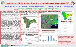
Fire Monitoring Service - Objective • Design, implement, and validate a fully automatic fire monitoring processing chain, for real time fire monitoring and rapid mapping, that combines in real-time: • Volumes of Earth Observation image acquisitions. • Volumes of fire monitoring products. • Models/Algorithms for data exchange and processing. • Auxiliary geo-information. • Human evidence, in order to draw reliable decisions and generate highly accurate fire products. 4
Fire Monitoring Service Front End: GUI Eumetsat @ 9.5°East Map Element Back End: MonetDB / Strabon • CorineLandcover • Admin Boundaries • POIs External Sources Geospatial Ontology Cataloguing Service & Metadata Creation Data Vault Web access based on Semantics • Search for raw and processed data • Refinement (Post-Processing) • Real-time fire monitoring using Linked Data Raw Data HotSpots Linked Geospatial Data Semantic technologies Processing Chain (SciQL based)
Requirements of the Fire Monitoring Service • Need for modeling of • Geospatial information • Temporal information • Product metadata • Product content • Need to link to other data sources • GIS data • Other information on the Web
Linked Data used in the Fire Monitoring Service • Hotspots detected by the National Observatory of Athens (NOA) and other authorities • Administrative Regions of Greece • Corine Land Use / Land Cover Nomenclature • LinkedGeoData • GeoNames
Linked Open Data (1/4) • Hotspots
Hotspots noa:Hotspot_15145 rdf:typenoa:Hotspot; noa:isDerivedFromSatellite "METEOSAT9"^^xsd:string; noa:isDerivedFromSensor "MSG2"^^xsd:string; noa:hasAcquisitionTime "2007-08-24T14:45:00” ^^xsd:dateTime; noa:producedFromProcessingChain "StaticThresholds“ ^^xsd:string; noa:hasConfirmationnoa:unknown; noa:hasConfidence "0.5"^^xsd:double; noa:hasGeometry "POLYGON((393801.42 4198827.92, ..., 393801.42 4198827.92)); <http://www.opengis.net/def/crs/EPSG/0/2100>“ ^^strdf:WKT.
Linked Open Data (2/4) • Greek Administrative Geography 05/11/12
Greek Administrative Geography gag:gag003000009002 rdf:typeowl:NamedIndividual ; rdf:typegag:Dhmos; rdfs:label "ΔΗΜΟΣ ΧΕΡΣΟΝΗΣΟΥ"@el; rdfs:label "Hersonissos"; noa:hasYpesCode "9309"^^xsd:integer; strdf:hasGeometry "MULTIPOLYGON (((25.37 35.34,...,25.21 35.47)))"^^strdf:WKT; gag:isPartOf gag:gag003000000101.
Linked Open Data (3/4) • Corine Land Use / Land Cover 05/11/12
Corine Land Use / Land Cover noa:Area_24015134 rdf:typenoa:Area ; noa:hasCode "312"^^xsd:decimal; noa:hasID "EU-203497"^^xsd:string; noa:hasArea_ha "255.580790497"^^xsd:double; noa:hasGeometry "POLYGON((15.53 62.54, ..., 15.53 62.54))"^^strdf:WKT; noa:hasLandUsenoa:coniferousForest. 14
Linked Open Data (4/4) • LinkedGeoData
LinkedGeoData • lgd:node741703450 rdf:typelgdo:Node; • rdf:typelgdo:Place; • rdf:typelgdo:Town; • rdfs:label"Зофори"@ru; • rdfs:label"Ζωφόροι"@el; • rdfs:label"Zofori"@en; • lgdo:directType lgdo:Town; • wgs84:geometry "POINT(25.270435.2061)"^^virtrdf:Geometry; • wgs84:lat "35.2060912"^^xsd:double; • wgs84:long "25.2703858"^^xsd:double; • lgdo:contributorlgd:user153221 .
Discovering raw data and products • Retrieve shapefiles that contain acquisitions taken between 12:00 and 12:30 of August 26, 2007 and acquired by sensor MSG2 SELECT ?filename WHERE { ?file rdf:typenoa:ShpFile . ?file noa:hasFilename ?filename . ?file noa:hasAcquisitionTime ?sensingTime . FILTER( str(?sensingTime) >= "2007-08-26T12:00:00" ) . FILTER( str(?sensingTime) <= "2007-08-26T12:30:00" ) . ?file noa:isDerivedFromSensor ?sensor . FILTER( str(?sensor) = "MSG2" ) . ?file noa:producedFromProcessingChain ?chain . FILTER( str(?chain) = "StaticThresholds" ) . }
Discovering raw data and products • Retrieve shapefiles that contain acquisitions taken between 12:00 and 12:30 of August 26, 2007 and acquired by sensor MSG2
Creating a map (1/4) • Get all hotspots detected in Peloponnese at 24/08/2007. SELECT ?h ?hConfidence ?hConfirmation ?hProvider ?hSensor ?hSatellite (strdf:transform(?hGeo, <http://www.opengis.net/def/crs/EPSG/0/4326>) as ?geo) WHERE { ?h rdf:type noa:Hotspot; noa:hasGeometry ?hGeo; noa:hasAcquisitionTime ?hAcqTime; noa:hasConfidence ?hConfidence; noa:isProducedBy ?hProvider; noa:hasConfirmation ?hConfirmation; noa:isDerivedFromSensor ?hSensor; noa:isDerivedFromSatellite ?hSatellite ; noa:producedFromProcessingChain ?hChain . FILTER(str(?hChain) = "StaticThresholds"). FILTER(?hAcqTime = "2007-08-24T14:45:00"^^xsd:dateTime) . FILTER(strdf:contains("POLYGON((21.027 38.36, 23.77 38.36, 23.77 36.05, 21.027 36.05, 21.027 38.36))"^^strdf:WKT, ?hGeo)) .
Improve product accuracy • Delete the parts of each hotspot that lie in the sea. DELETE {?h noa:hasGeometry ?hGeo} INSERT {?h noa:hasGeometry ?dif} WHERE { SELECT DISTINCT ?h ?hGeo (strdf:intersection(?hGeo, strdf:union(?cGeo)) AS ?dif) WHERE { ?h rdf:type noa:Hotspot. ?h strdf:hasGeometry ?hGeo. ?c rdf:type coast:Coastline. ?c strdf:hasGeometry ?cGeo. FILTER( strdf:intersects(?hGeo, ?cGeo)} GROUP BY ?h ?hGeo HAVING strdf:overlap(?hGeo, strdf:union(?cGeo))}
Creating a map (2/4) • Get all coniferous forests in Peloponnese SELECT ?a ?aGeo WHERE{ ?a rdf:type clc:Area; clc:hasLandUse ?aLandUse; noa:hasGeometry ?aGeo. ?aLandUse rdf:type ?aLandUseType. FILTER(?aLandUseType = clc:ConiferousForest). FILTER(strdf:contains("POLYGON((21.027 38.36, 23.77 38.36, 23.77 36.05, 21.027 36.05, 21.027 38.36))" ^^strdf:WKT,?aGeo)). }
Creating a map (3/4) • Get all municipalities of Peloponnese SELECT ?d ?dGeo WHERE { ?d rdf:type gag:Dhmos; strdf:hasGeometry ?dGeo; rdfs:label ?dLabel. FILTER(strdf:contains("POLYGON((21.027 38.36, 23.77 38.36, 23.77 36.05, 21.027 36.05, 21.027 38.36))"^^ strdf:WKT, ?dGeo)). }
Creating a map (4/4) • Get all primary roads in Pelloponnese SELECT ?r ?rGeo WHERE{ ?r a ?rType ; noa:hasGeometry ?rGeo . FILTER(?rType = lgdo:Primary) . FILTER(strdf:contains("POLYGON(( 21.027 38.36, 23.77 38.36, 23.77 36.05, 21.027 36.05, 21.027 38.36))"^^strdf:WKT, ?rGeo) ). }
Final map 05/11/12
Conclusions • Applications using Linked Geospatial Data • Examples of applications • NOA Hotspot Detection and Fire Monitoring Service • Datasets used • Queries leading to final map creation 25